
Mount Arashima
荒島岳
Ōno-shi, Fukui · Elevation 1,524 m
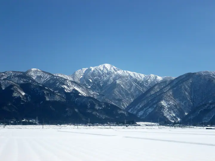
Mount Arashima is a 1,524 m isolated peak in Ōno City, Fukui Prefecture, whose symmetrical cone has earned it the nickname Ōno-Fuji. It is the only summit in Fukui listed in Fukada Kyūya's Hyakumeizan and is also counted among the Ittō-Sankakuten Hyakumeizan. From the summit the Hakusan range and Mount Nōgō-Hakusan are visible, while the surrounding ridges carry mature primary beech forest. The principal routes are the Katsuhara trail on the north face and the Nakande trail on the west, with additional approaches from Sabiraki and Shin-Shimoyama; rhododendrons in early summer and autumn foliage are highlights of the climb.
Mount Arashima at a glance
- Weather: The most settled day in the next 7 days is Wed, November 4: clear, gusts up to 6 m/s. Fri, Nov 6, Sat, Nov 7: strong wind (gusts up to 16 m/s).
- Route: The shortest is Mount Arashima Return via the Nakande Route and Ko-Arashimadake: about 7 h 24 min, 12.0 km, about 1,310 m of climbing.
Mount Arashima weather (hourly, 14 days)
Sunrise today 06:17, sunset 16:57
| Tue, 11/3 | Wed, 11/4 | Thu, 11/5 | Fri, 11/6 | Sat, 11/7 | Sun, 11/8 | Mon, 11/9 | Tue, 11/10 | Wed, 11/11 | Thu, 11/12 | Fri, 11/13 | Sat, 11/14 | Sun, 11/15 | Mon, 11/16 | Tue, 11/17 | |||||||||||||||||||||||||||||||||||||||||||||||||||||||||||||||||||||||
|---|---|---|---|---|---|---|---|---|---|---|---|---|---|---|---|---|---|---|---|---|---|---|---|---|---|---|---|---|---|---|---|---|---|---|---|---|---|---|---|---|---|---|---|---|---|---|---|---|---|---|---|---|---|---|---|---|---|---|---|---|---|---|---|---|---|---|---|---|---|---|---|---|---|---|---|---|---|---|---|---|---|---|---|---|---|
| Japan time | 15 | 17 | 19 | 21 | 23 | 1 | 3 | 5 | 7 | 9 | 11 | 13 | 15 | 18 | 21 | 0 | 3 | 6 | 9 | 12 | 15 | 18 | 21 | 0 | 3 | 6 | 9 | 12 | 15 | 18 | 21 | 0 | 3 | 6 | 9 | 12 | 15 | 18 | 21 | 0 | 3 | 6 | 9 | 12 | 15 | 18 | 21 | 0 | 3 | 6 | 9 | 15 | 21 | 3 | 9 | 15 | 21 | 3 | 9 | 15 | 21 | 3 | 9 | 15 | 21 | 3 | 9 | 15 | 21 | 3 | 9 | 15 | 21 | 3 | 9 | 15 | 21 | 3 | 9 | 15 | 21 | 3 | 9 | 15 | |
  |  | |   | | | | | | |  | | |   | |   | | |   | |   |   | | | | | |   |   | | | | | | | | |   | | | | | | | | | | | | | | | | | | | |   | | | |  | | | | | | | | | | | | | | | | | | | | | | | ||
| Temperature | °C | 9° | 4° | 1° | -1° | -2° | -1° | -2° | -3° | -3° | 6° | 11° | 12° | 11° | 7° | 6° | 6° | 6° | 5° | 7° | 11° | 12° | 8° | 7° | 7° | 7° | 6° | 7° | 9° | 6° | 4° | 2° | 1° | 0° | -1° | 0° | 2° | 2° | -1° | -1° | -2° | -2° | -2° | 2° | 5° | 5° | 1° | 1° | 1° | 1° | 1° | 5° | 5° | -2° | -2° | 4° | 5° | 1° | -3° | 0° | 1° | -3° | -7° | 1° | 4° | -3° | 0° | 2° | 3° | -4° | -6° | 4° | 8° | 2° | 3° | 5° | 6° | 5° | 6° | 7° | 6° | 0° | -3° | 1° | 5° |
| Precipitation | mm | 1.2 | 7 | 3.6 | 3.1 | 0.3 | 0.7 | 0.8 | 10 | 1.8 | 1.9 | 1.1 | 1.0 | 0.7 | 0.3 | 0.5 | 0.6 | 0.9 | 1.0 | 0.8 | 0.1 | 0.4 | 0.2 | 0.3 | 7 | 4.5 | 0.2 | 0.3 | 1.7 | 0.3 | 0.1 | 0.2 | 6 | 9 | 4.3 | 0.6 | 0.2 | ||||||||||||||||||||||||||||||||||||||||||||||||
| New snow | cm | 0.1 | |||||||||||||||||||||||||||||||||||||||||||||||||||||||||||||||||||||||||||||||||||
| Snow depth | cm | 0 | 0 | 0 | 0 | 0 | 0 | 0 | 0 | 0 | 0 | 0 | 0 | 0 | 0 | 0 | 0 | 0 | 0 | 0 | 0 | 0 | 0 | 0 | 0 | 0 | 0 | 0 | 0 | 0 | 0 | 0 | 0 | 0 | 0 | 0 | 0 | 0 | 0 | 0 | 0 | 0 | 0 | 0 | 0 | 0 | 0 | 0 | 0 | 0 | 0 | 0 | 0 | 0 | 0 | 0 | 0 | 0 | 0 | 0 | 0 | 0 | 0 | 0 | 0 | 0 | 0 | 0 | 0 | 0 | 0 | 0 | 0 | 0 | 0 | 0 | 0 | 0 | 0 | 0 | 0 | 0 | 0 | 0 | 0 |
| Wind | m/s | 4 | 2 | 1 | 0 | 1 | 0 | 0 | 0 | 1 | 1 | 1 | 1 | 1 | 1 | 1 | 0 | 2 | 1 | 1 | 0 | 1 | 1 | 1 | 2 | 1 | 3 | 3 | 6 | 5 | 4 | 4 | 5 | 4 | 3 | 4 | 6 | 6 | 3 | 3 | 2 | 2 | 1 | 2 | 4 | 2 | 1 | 0 | 0 | 0 | 0 | 2 | 3 | 0 | 2 | 2 | 3 | 2 | 6 | 5 | 5 | 2 | 0 | 1 | 4 | 1 | 1 | 3 | 4 | 0 | 0 | 2 | 3 | 2 | 2 | 3 | 3 | 3 | 1 | 3 | 5 | 2 | 1 | 1 | 2 |
| Wind gusts | m/s | 10 | 10 | 5 | 3 | 3 | 3 | 2 | 2 | 2 | 4 | 4 | 5 | 6 | 4 | 5 | 5 | 7 | 6 | 4 | 4 | 4 | 5 | 3 | 5 | 6 | 8 | 9 | 15 | 16 | 14 | 13 | 14 | 13 | 12 | 12 | 16 | 16 | 15 | 9 | 8 | 7 | 6 | 7 | 10 | 11 | 7 | 3 | 2 | 3 | 3 | 6 | 10 | 8 | 4 | 7 | 11 | 10 | 19 | 16 | 16 | 13 | 5 | 4 | 10 | 9 | 5 | 8 | 13 | 12 | 3 | 7 | 8 | 7 | 6 | 8 | 9 | 10 | 9 | 8 | 14 | 13 | 8 | 4 | 5 |
| Wind dir. | ↓ | ↓ | ↓ | ↓ | ↓ | ↓ | ↓ | ↓ | ↓ | ↓ | ↓ | ↓ | ↓ | ↓ | ↓ | ↓ | ↓ | ↓ | ↓ | ↓ | ↓ | ↓ | ↓ | ↓ | ↓ | ↓ | ↓ | ↓ | ↓ | ↓ | ↓ | ↓ | ↓ | ↓ | ↓ | ↓ | ↓ | ↓ | ↓ | ↓ | ↓ | ↓ | ↓ | ↓ | ↓ | ↓ | ↓ | ↓ | ↓ | ↓ | ↓ | ↓ | ↓ | ↓ | ↓ | ↓ | ↓ | ↓ | ↓ | ↓ | ↓ | ↓ | ↓ | ↓ | ↓ | ↓ | ↓ | ↓ | ↓ | ↓ | ↓ | ↓ | ↓ | ↓ | ↓ | ↓ | ↓ | ↓ | ↓ | ↓ | ↓ | ↓ | ↓ | ↓ | |
Mount Arashima hiking routes
- Mount Arashima Return via the Nakande Route and Ko-Arashimadake 12.0 km · Ascent 1,310 m parking
- Mount Arashima and Mount Ko-Arashima Return via the Kadohara Route 11.1 km · Ascent 1,341 m 荒島岳勝原登山口駐車場
Hiking times are estimates calculated from the terrain.
Huts, campsites and lodging near Mount Arashima
Campsites
- 勝原園地
Lists that include Mount Arashima
100 Famous Japanese Mountains · Japan 200 Famous Mountains · Japan's 300 Famous Mountains · 100 Famous Mountains with First-order Triangulation Points · New Japan 100 Famous Mountains · 100 Fujis of Japan · 100 Mountains of Hokuriku · Elevations of 1003 Mountains of Japan · 1000 Mountains of Japan
Mount Arashima facts
- Also known as
- 大野富士
- Elevation
- 1,524 m
- Location
- Ōno-shi, Fukui
35.934349, 136.601263 - Website
- www.city.ono.fukui.jp
- Trail Map
- www.city.ono.fukui.jp
- Wikipedia
- ja.wikipedia.org