
Mount Akagi
黒檜山
Numata, Gunma / Kiryū, Gunma / Maebashi, Gunma · Elevation 1,828 m
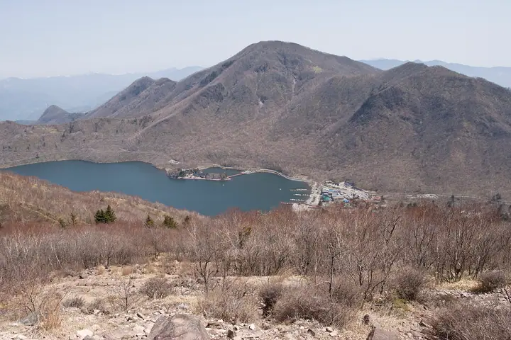
Mount Akagi is a complex volcano north of Maebashi whose highest summit, Kurobisan, reaches 1828 m. Its peaks include Komagatake, Jizodake, Arayama, Nabewariyama, Suzugatake and Choshichiroyama, alongside lakes Onuma and Konuma. An outer rim and lava domes within the caldera create varied volcanic terrain. The mountain has long been a focus of Akagi worship. Routes range from easy to intermediate, including walks around Kakumanbuchi and Konuma, a Jizodake ascent, and the Kurobisan–Komagatake traverse to the highest summit. Akagi Shrine and Akagi Park Visitor Center stand within the summit caldera.
Mount Akagi at a glance
- Weather: The most settled day in the next 7 days is Mon, November 9: clear, gusts up to 6 m/s. Sat, Nov 7, Sun, Nov 8: strong wind (gusts up to 20 m/s).
- Route: The shortest is Mount Kurobi on Mount Akagi from Kurobi Trailhead Out-and-Back: about 2 h 27 min, 3.6 km, about 490 m of climbing.
Mount Akagi weather (hourly, 14 days)
Sunrise today 06:08, sunset 16:46
| Tue, 11/3 | Wed, 11/4 | Thu, 11/5 | Fri, 11/6 | Sat, 11/7 | Sun, 11/8 | Mon, 11/9 | Tue, 11/10 | Wed, 11/11 | Thu, 11/12 | Fri, 11/13 | Sat, 11/14 | Sun, 11/15 | Mon, 11/16 | Tue, 11/17 | |||||||||||||||||||||||||||||||||||||||||||||||||||||||||||||||||||||||
|---|---|---|---|---|---|---|---|---|---|---|---|---|---|---|---|---|---|---|---|---|---|---|---|---|---|---|---|---|---|---|---|---|---|---|---|---|---|---|---|---|---|---|---|---|---|---|---|---|---|---|---|---|---|---|---|---|---|---|---|---|---|---|---|---|---|---|---|---|---|---|---|---|---|---|---|---|---|---|---|---|---|---|---|---|---|
| Japan time | 15 | 17 | 19 | 21 | 23 | 1 | 3 | 5 | 7 | 9 | 11 | 13 | 15 | 18 | 21 | 0 | 3 | 6 | 9 | 12 | 15 | 18 | 21 | 0 | 3 | 6 | 9 | 12 | 15 | 18 | 21 | 0 | 3 | 6 | 9 | 12 | 15 | 18 | 21 | 0 | 3 | 6 | 9 | 12 | 15 | 18 | 21 | 0 | 3 | 6 | 9 | 15 | 21 | 3 | 9 | 15 | 21 | 3 | 9 | 15 | 21 | 3 | 9 | 15 | 21 | 3 | 9 | 15 | 21 | 3 | 9 | 15 | 21 | 3 | 9 | 15 | 21 | 3 | 9 | 15 | 21 | 3 | 9 | 15 | |
  |   | |   | | | | |  | | | |   |   |   | | | |   | |   | | |  | | | | | | | | | | | | | | | | | | | | | | | | | | | | | | | | | | |   | |   | | | | | | | | |  | | | | | | | |   | |   | | | | | ||
| Temperature | °C | 7° | 4° | 2° | 1° | 2° | 0° | -1° | -2° | 0° | 6° | 8° | 8° | 6° | 4° | 3° | 4° | 4° | 4° | 6° | 9° | 10° | 6° | 5° | 4° | 4° | 4° | 11° | 14° | 12° | 6° | 6° | 4° | 3° | 2° | 3° | 4° | 2° | 0° | 0° | -1° | -1° | -1° | 3° | 5° | 4° | 0° | -1° | 0° | 0° | 0° | 2° | 4° | 2° | 0° | 1° | 4° | 1° | -1° | 0° | 1° | 0° | -1° | 2° | 5° | 0° | -2° | 3° | 2° | -1° | -3° | 1° | 3° | -3° | -3° | 5° | 7° | 4° | 3° | 10° | 7° | 1° | -2° | 1° | 3° |
| Precipitation | mm | 0.3 | 0.9 | 8 | 7 | 1.6 | 0.1 | 0.8 | 0.3 | 0.2 | 1.0 | 0.7 | 1.9 | 0.3 | 2.7 | 6 | 0.5 | ||||||||||||||||||||||||||||||||||||||||||||||||||||||||||||||||||||
| New snow | cm | <.1 | |||||||||||||||||||||||||||||||||||||||||||||||||||||||||||||||||||||||||||||||||||
| Snow depth | cm | 0 | 0 | 0 | 0 | 0 | 0 | 0 | 0 | 0 | 0 | 0 | 0 | 0 | 0 | 0 | 0 | 0 | 0 | 0 | 0 | 0 | 0 | 0 | 0 | 0 | 0 | 0 | 0 | 0 | 0 | 0 | 0 | 0 | 0 | 0 | 0 | 0 | 0 | 0 | 0 | 0 | 0 | 0 | 0 | 0 | 0 | 0 | 0 | 0 | 0 | 0 | 0 | 0 | 0 | 0 | 0 | 0 | 0 | 0 | 0 | 0 | 0 | 0 | 0 | 0 | 0 | 0 | 0 | 0 | 0 | 0 | 0 | 0 | 0 | 0 | 0 | 0 | 0 | 0 | 0 | 0 | 0 | 0 | 0 |
| Wind | m/s | 4 | 2 | 1 | 1 | 1 | 1 | 1 | 1 | 1 | 1 | 2 | 3 | 3 | 2 | 0 | 1 | 1 | 1 | 2 | 1 | 0 | 0 | 1 | 1 | 1 | 2 | 3 | 3 | 3 | 3 | 4 | 5 | 5 | 5 | 6 | 6 | 6 | 5 | 5 | 5 | 6 | 5 | 5 | 5 | 5 | 1 | 2 | 1 | 1 | 0 | 1 | 2 | 0 | 1 | 1 | 2 | 1 | 3 | 6 | 6 | 3 | 3 | 1 | 1 | 1 | 2 | 4 | 6 | 3 | 3 | 1 | 2 | 1 | 1 | 0 | 1 | 1 | 1 | 2 | 6 | 6 | 3 | 0 | 2 |
| Wind gusts | m/s | 13 | 12 | 6 | 4 | 4 | 3 | 4 | 4 | 4 | 4 | 7 | 9 | 9 | 8 | 6 | 4 | 4 | 5 | 6 | 7 | 4 | 4 | 3 | 4 | 4 | 6 | 10 | 10 | 12 | 10 | 14 | 16 | 17 | 17 | 18 | 19 | 20 | 19 | 15 | 16 | 18 | 18 | 16 | 16 | 15 | 13 | 5 | 4 | 3 | 4 | 5 | 6 | 5 | 4 | 5 | 7 | 8 | 11 | 22 | 25 | 23 | 12 | 10 | 6 | 6 | 7 | 14 | 19 | 18 | 13 | 10 | 7 | 5 | 3 | 3 | 6 | 4 | 5 | 7 | 21 | 23 | 20 | 10 | 7 |
| Wind dir. | ↓ | ↓ | ↓ | ↓ | ↓ | ↓ | ↓ | ↓ | ↓ | ↓ | ↓ | ↓ | ↓ | ↓ | ↓ | ↓ | ↓ | ↓ | ↓ | ↓ | ↓ | ↓ | ↓ | ↓ | ↓ | ↓ | ↓ | ↓ | ↓ | ↓ | ↓ | ↓ | ↓ | ↓ | ↓ | ↓ | ↓ | ↓ | ↓ | ↓ | ↓ | ↓ | ↓ | ↓ | ↓ | ↓ | ↓ | ↓ | ↓ | ↓ | ↓ | ↓ | ↓ | ↓ | ↓ | ↓ | ↓ | ↓ | ↓ | ↓ | ↓ | ↓ | ↓ | ↓ | ↓ | ↓ | ↓ | ↓ | ↓ | ↓ | ↓ | ↓ | ↓ | ↓ | ↓ | ↓ | ↓ | ↓ | ↓ | ↓ | ↓ | ↓ | ↓ | ↓ | |
Mount Akagi live cameras
Mount Akagi hiking routes
- Mount Kurobi on Mount Akagi from Kurobi Trailhead Out-and-Back 3.6 km · Ascent 491 m 黒檜山登山口駐車場 (parking)
- Mount Akagi: Mount Kurobi and Komagatake Loop 5.0 km · Ascent 562 m あかぎ広場前 (Bus stop), おのこ駐車場, 駒ヶ岳登山口駐車場 (parking)
Hiking times are estimates calculated from the terrain.
Huts, campsites and lodging near Mount Akagi
Mountain huts
- 上の避難小屋
Campsites
- 赤城バンガロー村 柴田テント
- 赤城バイブルキャンプ
- 赤城公園キャンプ場
- 利平茶屋森林公園キャンプ場
- Hanamigahara Forest Park Campground
Lodging
- 青木別館
- 大沼山荘
- みやま山荘
- 王鉄山荘
- 赤城少年自然の家
Lists that include Mount Akagi
100 Famous Japanese Mountains · Japan 200 Famous Mountains · Japan's 300 Famous Mountains · 100 Famous Mountains of Flowers · New 100 Famous Flower Mountains · Illustrated Collection of Japan's Famous Mountains · 100 Famous Hot Spring Mountains · Kanto 100 Famous Mountains · Gunma 100 Famous Mountains · 3 Mountains of Jomo · Elevations of 1003 Mountains of Japan · 1000 Mountains of Japan
Mount Akagi facts
- Also known as
- 黒桧山 · あかぎさん
- Elevation
- 1,828 m
- Location
- Numata, Gunma / Kiryū, Gunma / Maebashi, Gunma
36.560372, 139.193285 - Volcano
- Active volcano (赤城山)
- Website
- www.maebashi-cvb.com
- Trail Map
- www.maebashi-cvb.com
- Access Information
- www.maebashi-cvb.com
- Wikipedia
- ja.wikipedia.org