
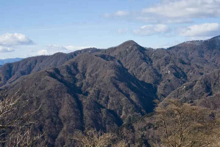
Dokaku no Atama
同角ノ頭
Yamakita, Kanagawa · Elevation 1,487 m
This peak stands on the Dokaku ridge linking Yushin, Oishiyama and Ishigoya no Atama with the Ishidana ridge. The route has repeated ascents and descents on narrow ridges with loose footing, and the start of the descent from the summit can be difficult to follow. As of October 2026, the Dokaku ridge trail from Yushin to Dokaku Junction is closed pending safety checks.
Dokaku no Atama at a glance
- Weather: The most settled day in the next 7 days is Fri, November 6: clear, gusts up to 8 m/s.
Dokaku no Atama weather (hourly, 14 days)
Sunrise today 06:06, sunset 16:48
| Tue, 11/3 | Wed, 11/4 | Thu, 11/5 | Fri, 11/6 | Sat, 11/7 | Sun, 11/8 | Mon, 11/9 | Tue, 11/10 | Wed, 11/11 | Thu, 11/12 | Fri, 11/13 | Sat, 11/14 | Sun, 11/15 | Mon, 11/16 | Tue, 11/17 | |||||||||||||||||||||||||||||||||||||||||||||||||||||||||||||||||||||||
|---|---|---|---|---|---|---|---|---|---|---|---|---|---|---|---|---|---|---|---|---|---|---|---|---|---|---|---|---|---|---|---|---|---|---|---|---|---|---|---|---|---|---|---|---|---|---|---|---|---|---|---|---|---|---|---|---|---|---|---|---|---|---|---|---|---|---|---|---|---|---|---|---|---|---|---|---|---|---|---|---|---|---|---|---|---|
| Japan time | 15 | 17 | 19 | 21 | 23 | 1 | 3 | 5 | 7 | 9 | 11 | 13 | 15 | 18 | 21 | 0 | 3 | 6 | 9 | 12 | 15 | 18 | 21 | 0 | 3 | 6 | 9 | 12 | 15 | 18 | 21 | 0 | 3 | 6 | 9 | 12 | 15 | 18 | 21 | 0 | 3 | 6 | 9 | 12 | 15 | 18 | 21 | 0 | 3 | 6 | 9 | 15 | 21 | 3 | 9 | 15 | 21 | 3 | 9 | 15 | 21 | 3 | 9 | 15 | 21 | 3 | 9 | 15 | 21 | 3 | 9 | 15 | 21 | 3 | 9 | 15 | 21 | 3 | 9 | 15 | 21 | 3 | 9 | 15 | |
  |   | |   | | | | |   | | | | | | | | | | |   | |   |   | | | |  | | |  | | | | | | | |   |   | | | |   | | | | | | | | | | | | |   | | | | |   |  | | | | | | | | | | | | | | | | |   | | | | | | ||
| Temperature | °C | 10° | 8° | 8° | 7° | 7° | 6° | 6° | 6° | 5° | 6° | 7° | 7° | 6° | 5° | 5° | 5° | 6° | 6° | 9° | 14° | 12° | 10° | 7° | 6° | 7° | 6° | 13° | 16° | 15° | 10° | 8° | 9° | 8° | 5° | 9° | 9° | 8° | 6° | 3° | 4° | 3° | 2° | 7° | 8° | 8° | 5° | 4° | 4° | 4° | 3° | 4° | 6° | 4° | 2° | 4° | 6° | 3° | 3° | 6° | 9° | -1° | -2° | 5° | 5° | 4° | 0° | 8° | 7° | 0° | 1° | 3° | 5° | 2° | 1° | 8° | 10° | 8° | 7° | 12° | 14° | 5° | 3° | 3° | 4° |
| Precipitation | mm | 0.2 | 0.3 | 0.3 | 1.0 | 2.2 | 6 | 10 | 17 | 15 | 2.5 | 1.2 | 0.2 | 1.5 | 0.4 | 0.8 | 0.5 | 0.3 | 1.0 | 0.1 | 0.2 | 0.1 | 10 | 24 | 0.7 | 0.1 | 0.2 | ||||||||||||||||||||||||||||||||||||||||||||||||||||||||||
| New snow | cm | ||||||||||||||||||||||||||||||||||||||||||||||||||||||||||||||||||||||||||||||||||||
| Snow depth | cm | 0 | 0 | 0 | 0 | 0 | 0 | 0 | 0 | 0 | 0 | 0 | 0 | 0 | 0 | 0 | 0 | 0 | 0 | 0 | 0 | 0 | 0 | 0 | 0 | 0 | 0 | 0 | 0 | 0 | 0 | 0 | 0 | 0 | 0 | 0 | 0 | 0 | 0 | 0 | 0 | 0 | 0 | 0 | 0 | 0 | 0 | 0 | 0 | 0 | 0 | 0 | 0 | 0 | 0 | 0 | 0 | 0 | 0 | 0 | 0 | 0 | 0 | 0 | 0 | 0 | 0 | 0 | 0 | 0 | 0 | 0 | 0 | 0 | 0 | 0 | 0 | 0 | 0 | 0 | 0 | 0 | 0 | 0 | 0 |
| Wind | m/s | 2 | 1 | 1 | 1 | 1 | 1 | 1 | 1 | 1 | 2 | 2 | 2 | 2 | 2 | 2 | 2 | 3 | 3 | 3 | 2 | 2 | 0 | 1 | 0 | 1 | 1 | 0 | 2 | 2 | 1 | 1 | 0 | 2 | 1 | 1 | 2 | 2 | 1 | 1 | 0 | 0 | 0 | 1 | 2 | 2 | 1 | 1 | 1 | 1 | 1 | 1 | 2 | 2 | 2 | 2 | 2 | 0 | 1 | 3 | 3 | 1 | 0 | 1 | 2 | 1 | 2 | 1 | 2 | 1 | 0 | 1 | 2 | 0 | 0 | 2 | 3 | 1 | 0 | 2 | 2 | 2 | 1 | 1 | 2 |
| Wind gusts | m/s | 5 | 5 | 3 | 2 | 3 | 4 | 4 | 5 | 5 | 6 | 6 | 7 | 7 | 7 | 7 | 8 | 8 | 10 | 11 | 11 | 8 | 5 | 4 | 4 | 5 | 5 | 5 | 7 | 8 | 6 | 5 | 4 | 8 | 7 | 5 | 6 | 6 | 6 | 4 | 4 | 4 | 3 | 4 | 8 | 7 | 5 | 4 | 4 | 5 | 5 | 5 | 7 | 7 | 6 | 6 | 7 | 7 | 6 | 14 | 15 | 9 | 6 | 5 | 9 | 7 | 6 | 6 | 7 | 6 | 4 | 4 | 6 | 6 | 3 | 8 | 13 | 11 | 10 | 7 | 8 | 7 | 7 | 5 | 6 |
| Wind dir. | ↓ | ↓ | ↓ | ↓ | ↓ | ↓ | ↓ | ↓ | ↓ | ↓ | ↓ | ↓ | ↓ | ↓ | ↓ | ↓ | ↓ | ↓ | ↓ | ↓ | ↓ | ↓ | ↓ | ↓ | ↓ | ↓ | ↓ | ↓ | ↓ | ↓ | ↓ | ↓ | ↓ | ↓ | ↓ | ↓ | ↓ | ↓ | ↓ | ↓ | ↓ | ↓ | ↓ | ↓ | ↓ | ↓ | ↓ | ↓ | ↓ | ↓ | ↓ | ↓ | ↓ | ↓ | ↓ | ↓ | ↓ | ↓ | ↓ | ↓ | ↓ | ↓ | ↓ | ↓ | ↓ | ↓ | ↓ | ↓ | ↓ | ↓ | ↓ | ↓ | ↓ | ↓ | ↓ | ↓ | ↓ | ↓ | ↓ | ↓ | ↓ | ↓ | ↓ | ||
Huts, campsites and lodging near Dokaku no Atama
Mountain huts
- 青ケ岳山荘 2026: open all year · reservation required · sleeps 35
- Yushin Lodge
- 蛭ヶ岳山荘 2026: open all year
- 犬越路避難小屋 unstaffed
- 鍋割山荘 2026: open all year
Campsites
- ユーシンロッジ
- 西丹沢マウントブリッジキャンプ場
- バウアーハウスジャパン キャンプ場
- ウェルキャンプ西丹沢
- 大石キャンプ場
Dokaku no Atama facts
- Elevation
- 1,487 m
- Location
- Yamakita, Kanagawa
35.465944, 139.104584 - Trail Map
- www.pref.kanagawa.jp
- Wikipedia
- ja.wikipedia.org