
Sannoto
三ノ塔
Hadano, Kanagawa · Elevation 1,205 m
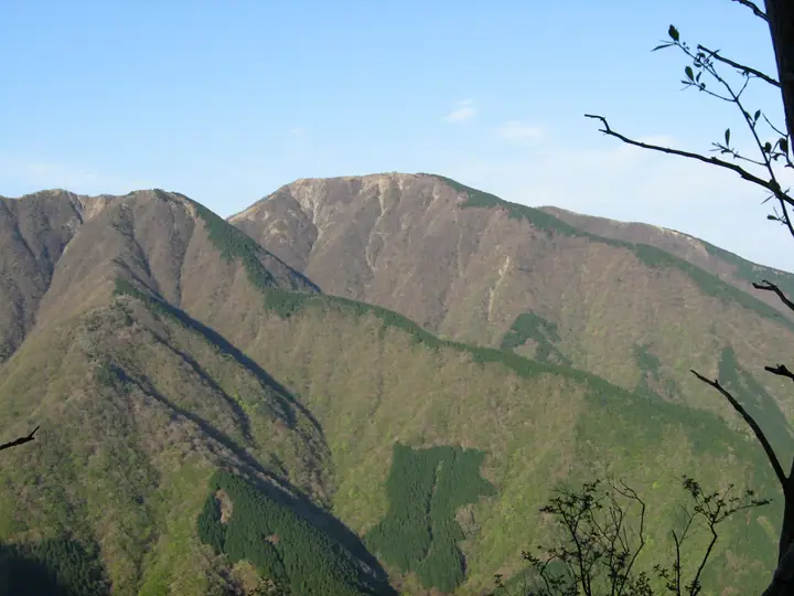
Sannoto is a 1,204.8 m peak in Hadano City, Kanagawa Prefecture, set midway between Yabitsu Pass and Mount To on the Omote-One ridge of the southeastern Tanzawa Mountains. Its open, north-south elongated summit commands views of the Tanzawa main ridge, Sagami Bay and Mount Fuji, and it holds the only unstaffed rest hut on the Omote-One together with an emergency shelter. The name derives from a legend at the foot Karako Shrine in which three sacred lights appeared on the mountain. It lies within Tanzawa-Oyama Quasi-National Park and is a popular waypoint on the ridge traverse to Mount To.
Sannoto at a glance
- Weather: The most settled day in the next 7 days is Fri, November 6: clear, gusts up to 8 m/s.
- Route: The shortest is Mount Tonodake Out-and-Back via the Omote Ridge from Bodai Pass: about 8 h 4 min, 11.8 km, about 1,330 m of climbing.
Sannoto weather (hourly, 14 days)
Sunrise today 06:06, sunset 16:48
| Tue, 11/3 | Wed, 11/4 | Thu, 11/5 | Fri, 11/6 | Sat, 11/7 | Sun, 11/8 | Mon, 11/9 | Tue, 11/10 | Wed, 11/11 | Thu, 11/12 | Fri, 11/13 | Sat, 11/14 | Sun, 11/15 | Mon, 11/16 | Tue, 11/17 | |||||||||||||||||||||||||||||||||||||||||||||||||||||||||||||||||||||||
|---|---|---|---|---|---|---|---|---|---|---|---|---|---|---|---|---|---|---|---|---|---|---|---|---|---|---|---|---|---|---|---|---|---|---|---|---|---|---|---|---|---|---|---|---|---|---|---|---|---|---|---|---|---|---|---|---|---|---|---|---|---|---|---|---|---|---|---|---|---|---|---|---|---|---|---|---|---|---|---|---|---|---|---|---|---|
| Japan time | 15 | 17 | 19 | 21 | 23 | 1 | 3 | 5 | 7 | 9 | 11 | 13 | 15 | 18 | 21 | 0 | 3 | 6 | 9 | 12 | 15 | 18 | 21 | 0 | 3 | 6 | 9 | 12 | 15 | 18 | 21 | 0 | 3 | 6 | 9 | 12 | 15 | 18 | 21 | 0 | 3 | 6 | 9 | 12 | 15 | 18 | 21 | 0 | 3 | 6 | 9 | 15 | 21 | 3 | 9 | 15 | 21 | 3 | 9 | 15 | 21 | 3 | 9 | 15 | 21 | 3 | 9 | 15 | 21 | 3 | 9 | 15 | 21 | 3 | 9 | 15 | 21 | 3 | 9 | 15 | 21 | 3 | 9 | 15 | |
  |   | |   | | | | |   | | | | | | | | | | |   | |   |   | | | |  | | |  | | | | | | | |   |   | | | |   | | | | | | | | | | | | |   | | | | |   |  | | | | | | | | | | | | | | | | |   | | | | | | ||
| Temperature | °C | 12° | 10° | 9° | 9° | 9° | 8° | 8° | 8° | 7° | 8° | 9° | 9° | 7° | 7° | 7° | 7° | 8° | 8° | 11° | 15° | 14° | 11° | 9° | 8° | 8° | 8° | 14° | 18° | 17° | 12° | 10° | 11° | 10° | 7° | 11° | 11° | 10° | 7° | 5° | 5° | 5° | 4° | 9° | 10° | 9° | 7° | 6° | 6° | 6° | 5° | 6° | 8° | 5° | 4° | 6° | 8° | 5° | 5° | 7° | 11° | 1° | 0° | 7° | 7° | 6° | 2° | 10° | 9° | 2° | 3° | 5° | 7° | 4° | 3° | 10° | 12° | 10° | 9° | 14° | 16° | 6° | 5° | 5° | 6° |
| Precipitation | mm | 0.2 | 0.3 | 0.3 | 1.0 | 2.2 | 6 | 10 | 17 | 15 | 2.5 | 1.2 | 0.2 | 1.5 | 0.4 | 0.8 | 0.5 | 0.3 | 1.0 | 0.1 | 0.2 | 0.1 | 10 | 24 | 0.7 | 0.1 | 0.2 | ||||||||||||||||||||||||||||||||||||||||||||||||||||||||||
| New snow | cm | ||||||||||||||||||||||||||||||||||||||||||||||||||||||||||||||||||||||||||||||||||||
| Snow depth | cm | 0 | 0 | 0 | 0 | 0 | 0 | 0 | 0 | 0 | 0 | 0 | 0 | 0 | 0 | 0 | 0 | 0 | 0 | 0 | 0 | 0 | 0 | 0 | 0 | 0 | 0 | 0 | 0 | 0 | 0 | 0 | 0 | 0 | 0 | 0 | 0 | 0 | 0 | 0 | 0 | 0 | 0 | 0 | 0 | 0 | 0 | 0 | 0 | 0 | 0 | 0 | 0 | 0 | 0 | 0 | 0 | 0 | 0 | 0 | 0 | 0 | 0 | 0 | 0 | 0 | 0 | 0 | 0 | 0 | 0 | 0 | 0 | 0 | 0 | 0 | 0 | 0 | 0 | 0 | 0 | 0 | 0 | 0 | 0 |
| Wind | m/s | 2 | 1 | 1 | 1 | 1 | 1 | 1 | 1 | 1 | 2 | 2 | 2 | 2 | 2 | 2 | 2 | 3 | 3 | 3 | 2 | 2 | 0 | 1 | 0 | 1 | 1 | 0 | 2 | 2 | 1 | 1 | 0 | 2 | 1 | 1 | 2 | 2 | 1 | 1 | 0 | 0 | 0 | 1 | 2 | 2 | 1 | 1 | 1 | 1 | 1 | 1 | 2 | 2 | 2 | 2 | 2 | 0 | 1 | 3 | 3 | 1 | 0 | 1 | 2 | 1 | 2 | 1 | 2 | 1 | 0 | 1 | 2 | 0 | 0 | 2 | 3 | 1 | 0 | 2 | 2 | 2 | 1 | 1 | 2 |
| Wind gusts | m/s | 5 | 5 | 3 | 2 | 3 | 4 | 4 | 5 | 5 | 6 | 6 | 7 | 7 | 7 | 7 | 8 | 8 | 10 | 11 | 11 | 8 | 5 | 4 | 4 | 5 | 5 | 5 | 7 | 8 | 6 | 5 | 4 | 8 | 7 | 5 | 6 | 6 | 6 | 4 | 4 | 4 | 3 | 4 | 8 | 7 | 5 | 4 | 4 | 5 | 5 | 5 | 7 | 7 | 6 | 6 | 7 | 7 | 6 | 14 | 15 | 9 | 6 | 5 | 9 | 7 | 6 | 6 | 7 | 6 | 4 | 4 | 6 | 6 | 3 | 8 | 13 | 11 | 10 | 7 | 8 | 7 | 7 | 5 | 6 |
| Wind dir. | ↓ | ↓ | ↓ | ↓ | ↓ | ↓ | ↓ | ↓ | ↓ | ↓ | ↓ | ↓ | ↓ | ↓ | ↓ | ↓ | ↓ | ↓ | ↓ | ↓ | ↓ | ↓ | ↓ | ↓ | ↓ | ↓ | ↓ | ↓ | ↓ | ↓ | ↓ | ↓ | ↓ | ↓ | ↓ | ↓ | ↓ | ↓ | ↓ | ↓ | ↓ | ↓ | ↓ | ↓ | ↓ | ↓ | ↓ | ↓ | ↓ | ↓ | ↓ | ↓ | ↓ | ↓ | ↓ | ↓ | ↓ | ↓ | ↓ | ↓ | ↓ | ↓ | ↓ | ↓ | ↓ | ↓ | ↓ | ↓ | ↓ | ↓ | ↓ | ↓ | ↓ | ↓ | ↓ | ↓ | ↓ | ↓ | ↓ | ↓ | ↓ | ↓ | ↓ | ||
Sannoto hiking routes
- Mount Tonodake Out-and-Back via the Omote Ridge from Bodai Pass 11.8 km · Ascent 1,335 m parking
- Yabitsu Pass to Mount Tanzawa via the Omote Ridge and Okura Ridge 19.8 km · Ascent 1,555 m Yabitsu pass (Bus stop) (parking) → Okura (Bus stop), Okura Parking
Hiking times are estimates calculated from the terrain.
Huts, campsites and lodging near Sannoto
Mountain huts
- 作治小屋 2026: open all year · sleeps 40
- 新茅山荘 2026: open all year
- 新茅荘
- Seizanso 2015: open all year · reservation required · sleeps 150
- Kinomata Hut 2026: open all year · sleeps 14
Campsites
- BOSCO Auto Camp
- BOSCOオートキャンプベース
- 表丹沢野外活動センター
- Ookurakougen tent site
- 滝沢園キャンプ場
Lodging
- 国民宿舎丹沢ホーム
Sannoto facts
- Also known as
- 水沢ノ頭・菩提山・ボディ峰・三ノ所・三ノ燈
- Elevation
- 1,205 m
- Location
- Hadano, Kanagawa
35.436569, 139.191558 - National Park
- 丹沢大山国定公園
- Website
- www.kankou-hadano.org
- Trail Map
- kankou-hadano.org
- Wikipedia
- ja.wikipedia.org