
Mount Ōyama
大山
Isehara, Kanagawa · Elevation 1,252 m
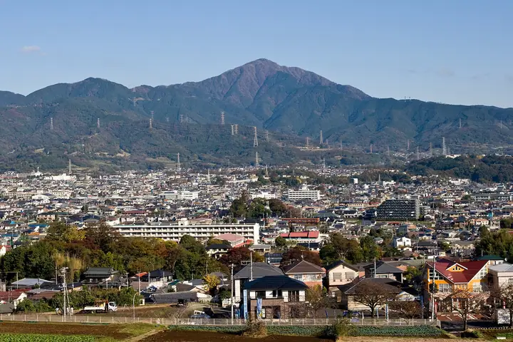
Mount Ōyama is a 1,252 m peak in Isehara, Hadano, and Atsugi cities in Kanagawa Prefecture, sitting at the southeastern end of the Tanzawa Range within Tanzawa-Ōyama Quasi-National Park. Its sharp pyramid shape has made it a focus of Kantō-region mountain worship since antiquity — it is also known as Afuri-san or Afuri-yama ("rain-bringing mountain"). The Ōyama-Afuri Shrine, with branches on the summit and at the 696 m mid-mountain shrine, is said to have been founded some 2,200 years ago. Listed in the Nihon Sanbyaku Meizan, the Hana no Hyakumeizan, the Kantō Hyakumeizan, the Kantō Hyakuzan, the Nihon Hyakuteizan, and the Nihon Hyaku Reizan among many others, it is one of the most-loved hiking peaks in greater Tōkyō. The standard ascent rides the Ōyama Cable Car (operated by Ōyama Kankō Dentetsu — Good Design Award 2016) up to the lower shrine and follows the Omote-Sandō (Honsaka) trail to the summit, a roughly three-hour round trip. The summit views span Sagami Bay, the Miura Peninsula, Mount Fuji, and the southern Akaishi Alps.
Mount Ōyama at a glance
- Weather: The most settled day in the next 7 days is Fri, November 6: clear, gusts up to 7 m/s.
- Route: The shortest is Mount Oyama Omotesando Round Trip from Afuri Shrine Lower Shrine: about 3 h 6 min, 4.2 km, about 590 m of climbing.
Mount Ōyama weather (hourly, 14 days)
Sunrise today 06:06, sunset 16:48
| Tue, 11/3 | Wed, 11/4 | Thu, 11/5 | Fri, 11/6 | Sat, 11/7 | Sun, 11/8 | Mon, 11/9 | Tue, 11/10 | Wed, 11/11 | Thu, 11/12 | Fri, 11/13 | Sat, 11/14 | Sun, 11/15 | Mon, 11/16 | Tue, 11/17 | |||||||||||||||||||||||||||||||||||||||||||||||||||||||||||||||||||||||
|---|---|---|---|---|---|---|---|---|---|---|---|---|---|---|---|---|---|---|---|---|---|---|---|---|---|---|---|---|---|---|---|---|---|---|---|---|---|---|---|---|---|---|---|---|---|---|---|---|---|---|---|---|---|---|---|---|---|---|---|---|---|---|---|---|---|---|---|---|---|---|---|---|---|---|---|---|---|---|---|---|---|---|---|---|---|
| Japan time | 15 | 17 | 19 | 21 | 23 | 1 | 3 | 5 | 7 | 9 | 11 | 13 | 15 | 18 | 21 | 0 | 3 | 6 | 9 | 12 | 15 | 18 | 21 | 0 | 3 | 6 | 9 | 12 | 15 | 18 | 21 | 0 | 3 | 6 | 9 | 12 | 15 | 18 | 21 | 0 | 3 | 6 | 9 | 12 | 15 | 18 | 21 | 0 | 3 | 6 | 9 | 15 | 21 | 3 | 9 | 15 | 21 | 3 | 9 | 15 | 21 | 3 | 9 | 15 | 21 | 3 | 9 | 15 | 21 | 3 | 9 | 15 | 21 | 3 | 9 | 15 | 21 | 3 | 9 | 15 | 21 | 3 | 9 | 15 | |
  |   |   | | | | | |   | | | | | | | | | | |   |   |   |   |   | | |  | | |  | | | | | | |   | | | | | | | | | | | | | | | | | | | | | | | |   |  | | | | | | | | | | | | | | | | |   | | |   | | | ||
| Temperature | °C | 10° | 8° | 7° | 7° | 7° | 6° | 6° | 6° | 5° | 6° | 7° | 7° | 6° | 5° | 4° | 5° | 5° | 7° | 9° | 13° | 12° | 9° | 7° | 6° | 6° | 6° | 11° | 15° | 14° | 9° | 8° | 8° | 7° | 4° | 8° | 9° | 9° | 6° | 3° | 2° | 2° | 2° | 6° | 8° | 7° | 5° | 4° | 4° | 4° | 3° | 4° | 6° | 4° | 2° | 4° | 6° | 2° | 3° | 6° | 9° | 0° | -1° | 5° | 6° | 4° | 1° | 8° | 7° | 1° | 0° | 2° | 5° | 3° | 2° | 7° | 10° | 7° | 7° | 11° | 14° | 5° | 3° | 3° | 4° |
| Precipitation | mm | 0.2 | 0.2 | 0.3 | 0.3 | 1.0 | 1.7 | 4.9 | 12 | 17 | 15 | 1.4 | 0.8 | 0.4 | 0.1 | 0.7 | 0.2 | 0.1 | 0.1 | 7 | 17 | 0.7 | 0.1 | ||||||||||||||||||||||||||||||||||||||||||||||||||||||||||||||
| New snow | cm | ||||||||||||||||||||||||||||||||||||||||||||||||||||||||||||||||||||||||||||||||||||
| Snow depth | cm | 0 | 0 | 0 | 0 | 0 | 0 | 0 | 0 | 0 | 0 | 0 | 0 | 0 | 0 | 0 | 0 | 0 | 0 | 0 | 0 | 0 | 0 | 0 | 0 | 0 | 0 | 0 | 0 | 0 | 0 | 0 | 0 | 0 | 0 | 0 | 0 | 0 | 0 | 0 | 0 | 0 | 0 | 0 | 0 | 0 | 0 | 0 | 0 | 0 | 0 | 0 | 0 | 0 | 0 | 0 | 0 | 0 | 0 | 0 | 0 | 0 | 0 | 0 | 0 | 0 | 0 | 0 | 0 | 0 | 0 | 0 | 0 | 0 | 0 | 0 | 0 | 0 | 0 | 0 | 0 | 0 | 0 | 0 | 0 |
| Wind | m/s | 2 | 1 | 1 | 1 | 2 | 2 | 2 | 2 | 2 | 2 | 2 | 2 | 2 | 3 | 3 | 3 | 4 | 4 | 4 | 3 | 1 | 1 | 1 | 1 | 1 | 1 | 0 | 2 | 2 | 1 | 1 | 1 | 1 | 1 | 1 | 2 | 2 | 2 | 1 | 1 | 1 | 1 | 1 | 1 | 2 | 1 | 0 | 1 | 2 | 2 | 2 | 2 | 2 | 2 | 2 | 2 | 1 | 0 | 1 | 2 | 2 | 1 | 1 | 2 | 1 | 2 | 1 | 2 | 1 | 1 | 1 | 2 | 1 | 0 | 1 | 3 | 1 | 0 | 1 | 2 | 2 | 2 | 2 | 2 |
| Wind gusts | m/s | 5 | 5 | 3 | 3 | 4 | 5 | 5 | 5 | 5 | 6 | 7 | 7 | 7 | 7 | 8 | 8 | 10 | 11 | 12 | 11 | 8 | 3 | 3 | 3 | 4 | 4 | 4 | 6 | 7 | 5 | 4 | 3 | 3 | 4 | 4 | 6 | 5 | 5 | 5 | 3 | 3 | 3 | 4 | 6 | 6 | 5 | 3 | 3 | 4 | 5 | 6 | 7 | 7 | 7 | 7 | 8 | 5 | 4 | 8 | 10 | 7 | 5 | 3 | 7 | 6 | 5 | 5 | 7 | 6 | 5 | 4 | 6 | 5 | 3 | 5 | 9 | 8 | 11 | 5 | 7 | 9 | 6 | 5 | 6 |
| Wind dir. | ↓ | ↓ | ↓ | ↓ | ↓ | ↓ | ↓ | ↓ | ↓ | ↓ | ↓ | ↓ | ↓ | ↓ | ↓ | ↓ | ↓ | ↓ | ↓ | ↓ | ↓ | ↓ | ↓ | ↓ | ↓ | ↓ | ↓ | ↓ | ↓ | ↓ | ↓ | ↓ | ↓ | ↓ | ↓ | ↓ | ↓ | ↓ | ↓ | ↓ | ↓ | ↓ | ↓ | ↓ | ↓ | ↓ | ↓ | ↓ | ↓ | ↓ | ↓ | ↓ | ↓ | ↓ | ↓ | ↓ | ↓ | ↓ | ↓ | ↓ | ↓ | ↓ | ↓ | ↓ | ↓ | ↓ | ↓ | ↓ | ↓ | ↓ | ↓ | ↓ | ↓ | ↓ | ↓ | ↓ | ↓ | ↓ | ↓ | ↓ | ↓ | ↓ | ↓ | ↓ | |
Mount Ōyama hiking routes
- Mount Oyama Omotesando Round Trip from Afuri Shrine Lower Shrine 4.2 km · Ascent 588 m 阿夫利神社 (Station)
- Yabitsu Pass to Oyama Cable via Mount Oyama 5.9 km · Ascent 496 m Yabitsu pass (Bus stop) (parking) → 大山ケーブル (Bus stop), 大山ケーブルバス停 (Bus stop), 良弁滝 (Bus stop), 伊勢原市営大山第2駐車場 (parking)
- Yabitsu Pass to Mount Oyama, Miharashi-dai, and Oyama Afuri Shrine Lower Shrine Traverse 7.6 km · Ascent 579 m Yabitsu pass (Bus stop) (parking) → 大山ケーブル (Bus stop), 大山ケーブルバス停 (Bus stop), 良弁滝 (Bus stop), 伊勢原市営大山第2駐車場 (parking)
- Mount Oyama Traverse from Yabitsu Pass to Koutakuji Onsen 9.7 km · Ascent 614 m Yabitsu pass (Bus stop) (parking) → 広沢寺温泉 (Bus stop) (parking)
- Oyama Cable Bus Stop, Afuri Shrine Lower Shrine, and Mount Oyama Out-and-Back 7.4 km · Ascent 952 m 伊勢原市営大山第2駐車場, 大山ケーブルバス停 (Bus stop), 大山ケーブル (Bus stop) (parking)
- Mount Ōyama Out-and-Back via Kaminari-no-mine Ridge from Hinata Campground 8.2 km · Ascent 930 m parking
- Mount Oyama Circuit from Oyama Cable via Afuri Shrine Lower Shrine and Miharashidai 8.5 km · Ascent 994 m 大山ケーブル (Bus stop), 大山ケーブルバス停 (Bus stop), 良弁滝 (Bus stop), 伊勢原市営大山第2駐車場 (parking)
- Isehara Oyama Omote-sando to the Summit and Down by Miharashidai and Tsuzura-ori to Hinata Yakushi 9.5 km · Ascent 969 m 大山ケーブル (Bus stop), 大山ケーブルバス停 (Bus stop), 良弁滝 (Bus stop), 伊勢原市営大山第2駐車場 (parking) → 日向薬師バス停 (Bus stop), Hinatayakushi (Bus stop), 日向薬師駐車場
Hiking times are estimates calculated from the terrain.
Huts, campsites and lodging near Mount Ōyama
Mountain huts
Campsites
- BOSCOオートキャンプベース
- BOSCO Auto Camp
- 表丹沢野外活動センター
Lodging
- 国民宿舎丹沢ホーム
- 大滝荘 たけだ
- Gyokusuiro
Lists that include Mount Ōyama
Japan's 300 Famous Mountains · 100 Famous Mountains of Flowers · 100 Low Mountains of Japan · Illustrated Collection of Japan's Famous Mountains · Kanto 100 Famous Mountains · Elevations of 1003 Mountains of Japan · 1000 Mountains of Japan
Mount Ōyama facts
- Also known as
- 雨降山・阿夫利山
- Elevation
- 1,252 m
- Location
- Isehara, Kanagawa
35.440830, 139.231335 - National Park
- 丹沢大山国定公園
- Website
- tanzawa-oyama.jp
- Access Information
- tanzawa-oyama.jp
- Wikipedia
- ja.wikipedia.org