
Mt. Yakuraisan
薬萊山
Kami, Miyagi · Elevation 553 m
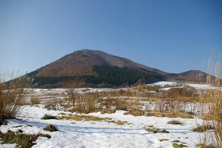
Yakurai-san (553 m) is a conical, free-standing peak rising near the center of Kami Town, Miyagi Prefecture, nicknamed 'Kami-Fuji' for its Fuji-like shape. Part of the Funagata Range Prefectural Nature Park, it offers sweeping views over the Osaki Plain from its summit. Its name is said to come from the enshrinement of Yakushi Nyorai on the peak in 735 to quell an epidemic, and the foothills hold the Yakurai highland resort with cherry-lined avenues and a ski area. It appears on many lists, including the 100 Famous Mountains of Tohoku.
Mt. Yakuraisan at a glance
- Weather: The most settled day in the next 7 days is Wed, November 4: clear, gusts up to 9 m/s. Sat, Nov 7, Sun, Nov 8: strong wind (gusts up to 23 m/s).
- Route: The shortest is Mount Yakurai, the Kami Fuji, Loop from the Yakurai Garden Side via the North Trailhead: about 2 h 9 min, 4.0 km, about 350 m of climbing.
Mt. Yakuraisan weather (hourly, 14 days)
Sunrise today 06:05, sunset 16:37
| Tue, 11/3 | Wed, 11/4 | Thu, 11/5 | Fri, 11/6 | Sat, 11/7 | Sun, 11/8 | Mon, 11/9 | Tue, 11/10 | Wed, 11/11 | Thu, 11/12 | Fri, 11/13 | Sat, 11/14 | Sun, 11/15 | Mon, 11/16 | Tue, 11/17 | |||||||||||||||||||||||||||||||||||||||||||||||||||||||||||||||||||||||
|---|---|---|---|---|---|---|---|---|---|---|---|---|---|---|---|---|---|---|---|---|---|---|---|---|---|---|---|---|---|---|---|---|---|---|---|---|---|---|---|---|---|---|---|---|---|---|---|---|---|---|---|---|---|---|---|---|---|---|---|---|---|---|---|---|---|---|---|---|---|---|---|---|---|---|---|---|---|---|---|---|---|---|---|---|---|
| Japan time | 15 | 17 | 19 | 21 | 23 | 1 | 3 | 5 | 7 | 9 | 11 | 13 | 15 | 18 | 21 | 0 | 3 | 6 | 9 | 12 | 15 | 18 | 21 | 0 | 3 | 6 | 9 | 12 | 15 | 18 | 21 | 0 | 3 | 6 | 9 | 12 | 15 | 18 | 21 | 0 | 3 | 6 | 9 | 12 | 15 | 18 | 21 | 0 | 3 | 6 | 9 | 15 | 21 | 3 | 9 | 15 | 21 | 3 | 9 | 15 | 21 | 3 | 9 | 15 | 21 | 3 | 9 | 15 | 21 | 3 | 9 | 15 | 21 | 3 | 9 | 15 | 21 | 3 | 9 | 15 | 21 | 3 | 9 | 15 | |
 |  | | | | | |   |   | | |   | | | |   |   | |   |   | | | |   | | |   | | | | | | | |   | |   |   |   | | | | |   | | | | |   | | | |   | | | | | | | | | | | | | | | | |  | | | | | | | | | | |   | | | | ||
| Temperature | °C | 9° | 6° | 5° | 4° | 4° | 2° | 2° | 2° | 5° | 10° | 12° | 12° | 12° | 7° | 6° | 6° | 7° | 7° | 8° | 9° | 10° | 10° | 11° | 9° | 9° | 7° | 13° | 15° | 15° | 9° | 7° | 4° | 3° | 2° | 2° | 3° | 3° | 1° | 1° | 1° | 1° | 1° | 4° | 5° | 5° | 4° | 3° | 2° | 3° | 2° | 5° | 6° | 1° | -1° | 4° | 6° | 3° | 3° | 3° | 7° | 2° | 2° | 6° | 6° | 3° | 4° | 5° | 5° | 2° | 0° | 4° | 8° | 0° | 0° | 6° | 10° | 6° | 6° | 9° | 7° | 2° | 1° | 4° | 6° |
| Precipitation | mm | 0.9 | 5 | 10 | 2.4 | 3.1 | 1.4 | 0.8 | 1.1 | 0.2 | 0.7 | 0.5 | 0.5 | 0.6 | 1.3 | 2.2 | 1.7 | 1.1 | 1.5 | 0.7 | 1.0 | 1.0 | 0.9 | 0.6 | 0.3 | 1.4 | 2.3 | 0.2 | 2.1 | 0.7 | 0.6 | 6 | 0.7 | 1.6 | 1.3 | ||||||||||||||||||||||||||||||||||||||||||||||||||
| New snow | cm | <.1 | <.1 | <.1 | <.1 | <.1 | <.1 | <.1 | <.1 | ||||||||||||||||||||||||||||||||||||||||||||||||||||||||||||||||||||||||||||
| Snow depth | cm | 0 | 0 | 0 | 0 | 0 | 0 | 0 | 0 | 0 | 0 | 0 | 0 | 0 | 0 | 0 | 0 | 0 | 0 | 0 | 0 | 0 | 0 | 0 | 0 | 0 | 0 | 0 | 0 | 0 | 0 | 0 | 0 | 0 | 0 | 0 | 0 | <1 | <1 | <1 | <1 | <1 | <1 | 0 | 0 | 0 | 0 | 0 | 0 | 0 | 0 | 0 | 0 | 0 | 0 | 0 | 0 | 0 | <1 | 0 | 0 | 0 | 0 | 0 | 0 | 0 | 0 | 0 | 0 | 0 | 0 | 0 | 0 | 0 | 0 | 0 | 0 | 0 | 0 | 0 | 0 | 0 | 0 | 0 | 0 |
| Wind | m/s | 6 | 4 | 3 | 4 | 3 | 2 | 3 | 3 | 3 | 3 | 4 | 3 | 1 | 2 | 2 | 2 | 1 | 1 | 1 | 1 | 1 | 1 | 0 | 2 | 2 | 2 | 2 | 6 | 6 | 8 | 8 | 8 | 8 | 8 | 6 | 6 | 6 | 6 | 6 | 6 | 7 | 7 | 8 | 10 | 9 | 6 | 3 | 3 | 3 | 2 | 4 | 4 | 3 | 3 | 2 | 5 | 1 | 5 | 6 | 6 | 4 | 3 | 3 | 3 | 1 | 1 | 6 | 7 | 5 | 2 | 1 | 3 | 1 | 1 | 1 | 2 | 0 | 0 | 3 | 5 | 7 | 6 | 5 | 4 |
| Wind gusts | m/s | 15 | 13 | 9 | 8 | 8 | 6 | 5 | 6 | 6 | 8 | 9 | 9 | 7 | 6 | 5 | 4 | 4 | 2 | 2 | 3 | 3 | 3 | 3 | 5 | 4 | 4 | 5 | 12 | 15 | 17 | 17 | 18 | 17 | 16 | 17 | 16 | 16 | 14 | 13 | 14 | 14 | 16 | 17 | 22 | 23 | 18 | 13 | 7 | 7 | 7 | 9 | 11 | 9 | 6 | 6 | 11 | 11 | 9 | 13 | 18 | 13 | 8 | 8 | 11 | 7 | 4 | 12 | 17 | 15 | 10 | 5 | 8 | 7 | 3 | 3 | 6 | 4 | 2 | 7 | 12 | 18 | 16 | 12 | 11 |
| Wind dir. | ↓ | ↓ | ↓ | ↓ | ↓ | ↓ | ↓ | ↓ | ↓ | ↓ | ↓ | ↓ | ↓ | ↓ | ↓ | ↓ | ↓ | ↓ | ↓ | ↓ | ↓ | ↓ | ↓ | ↓ | ↓ | ↓ | ↓ | ↓ | ↓ | ↓ | ↓ | ↓ | ↓ | ↓ | ↓ | ↓ | ↓ | ↓ | ↓ | ↓ | ↓ | ↓ | ↓ | ↓ | ↓ | ↓ | ↓ | ↓ | ↓ | ↓ | ↓ | ↓ | ↓ | ↓ | ↓ | ↓ | ↓ | ↓ | ↓ | ↓ | ↓ | ↓ | ↓ | ↓ | ↓ | ↓ | ↓ | ↓ | ↓ | ↓ | ↓ | ↓ | ↓ | ↓ | ↓ | ↓ | ↓ | ↓ | ↓ | ↓ | ↓ | ↓ | |||
Mt. Yakuraisan hiking routes
Hiking times are estimates calculated from the terrain.
Huts, campsites and lodging near Mt. Yakuraisan
Lodging
- Yakurai Rinsenkan
- 農家民宿 花袋天王
Lists that include Mt. Yakuraisan
Tohoku 100 Famous Mountains · Elevations of 1003 Mountains of Japan · 1000 Mountains of Japan
Mt. Yakuraisan facts
- Also known as
- 加美富士
- Elevation
- 553 m
- Location
- Kami, Miyagi
38.575561, 140.705246 - Website
- www.town.kami.miyagi.jp
- Wikipedia
- ja.wikipedia.org