
Mt. Tenjinmaru
天神丸
Mima, Tokushima / Naka-chō, Tokushima · Elevation 1,632 m
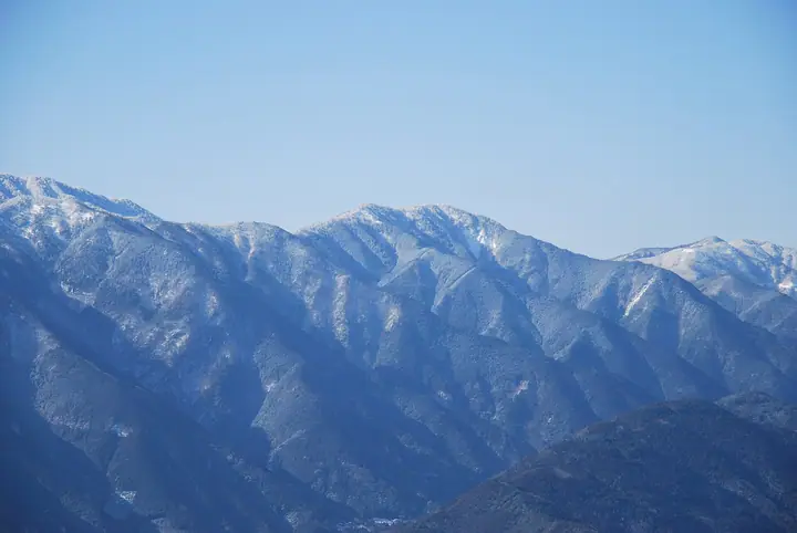
Tenjinmaru is a 1,631.5 m peak straddling the boundary between Mima City and Naka Town in Tokushima Prefecture, sitting on the main ridge of the Tsurugi Mountains roughly midway between Mount Tsurugi and Mount Takashiro. The peak lies within Tsurugisan Quasi-National Park, and is most often approached from where the Tsurugi Super Forestry Road crosses the ridge near Hinada Pass. It is listed in both the Tokushima Prefecture Mountain Guide and the Shikoku Hyakuzan.
Mt. Tenjinmaru at a glance
- Weather: The most settled day in the next 7 days is Sun, November 8: clear, gusts up to 9 m/s. Fri, Nov 6, Sat, Nov 7: strong wind (gusts up to 18 m/s).
Mt. Tenjinmaru weather (hourly, 14 days)
Sunrise today 06:24, sunset 17:10
| Tue, 11/3 | Wed, 11/4 | Thu, 11/5 | Fri, 11/6 | Sat, 11/7 | Sun, 11/8 | Mon, 11/9 | Tue, 11/10 | Wed, 11/11 | Thu, 11/12 | Fri, 11/13 | Sat, 11/14 | Sun, 11/15 | Mon, 11/16 | Tue, 11/17 | |||||||||||||||||||||||||||||||||||||||||||||||||||||||||||||||||||||||
|---|---|---|---|---|---|---|---|---|---|---|---|---|---|---|---|---|---|---|---|---|---|---|---|---|---|---|---|---|---|---|---|---|---|---|---|---|---|---|---|---|---|---|---|---|---|---|---|---|---|---|---|---|---|---|---|---|---|---|---|---|---|---|---|---|---|---|---|---|---|---|---|---|---|---|---|---|---|---|---|---|---|---|---|---|---|
| Japan time | 15 | 17 | 19 | 21 | 23 | 1 | 3 | 5 | 7 | 9 | 11 | 13 | 15 | 18 | 21 | 0 | 3 | 6 | 9 | 12 | 15 | 18 | 21 | 0 | 3 | 6 | 9 | 12 | 15 | 18 | 21 | 0 | 3 | 6 | 9 | 12 | 15 | 18 | 21 | 0 | 3 | 6 | 9 | 12 | 15 | 18 | 21 | 0 | 3 | 6 | 9 | 15 | 21 | 3 | 9 | 15 | 21 | 3 | 9 | 15 | 21 | 3 | 9 | 15 | 21 | 3 | 9 | 15 | 21 | 3 | 9 | 15 | 21 | 3 | 9 | 15 | 21 | 3 | 9 | 15 | 21 | 3 | 9 | 15 | |
 |   |   |   |   | | | |   | |   | | | |   | | | |   | | | | | | |   | | | |  | | | | | | | | | | | | | | | | | | | | | | | | | | | | |   | | | | | | | | |   | | | | | | | | | | | | | | | | | ||
| Temperature | °C | 9° | 6° | 4° | 3° | 4° | 4° | 4° | 4° | 4° | 6° | 9° | 9° | 10° | 7° | 7° | 7° | 9° | 9° | 11° | 14° | 15° | 9° | 10° | 11° | 10° | 6° | 8° | 11° | 9° | 4° | 2° | 0° | 0° | 0° | 1° | 4° | 4° | 0° | -2° | -3° | -4° | -3° | 5° | 8° | 7° | 2° | 2° | 1° | 2° | 2° | 6° | 8° | 1° | 0° | 4° | 6° | 0° | -1° | 0° | 3° | -2° | -5° | 4° | 8° | -1° | 1° | 4° | 4° | -2° | -3° | 5° | 10° | 1° | 2° | 9° | 9° | 9° | 7° | 8° | 9° | 4° | 0° | 3° | 7° |
| Precipitation | mm | 0.5 | 2.3 | 0.1 | 0.7 | 1.2 | 0.1 | 0.1 | 0.3 | 0.2 | 0.1 | 0.1 | 0.5 | 0.4 | 8 | 0.5 | 0.3 | 0.8 | 3.3 | 0.9 | |||||||||||||||||||||||||||||||||||||||||||||||||||||||||||||||||
| New snow | cm | ||||||||||||||||||||||||||||||||||||||||||||||||||||||||||||||||||||||||||||||||||||
| Snow depth | cm | 0 | 0 | 0 | 0 | 0 | 0 | 0 | 0 | 0 | 0 | 0 | 0 | 0 | 0 | 0 | 0 | 0 | 0 | 0 | 0 | 0 | 0 | 0 | 0 | 0 | 0 | 0 | 0 | 0 | 0 | 0 | 0 | 0 | 0 | 0 | 0 | 0 | 0 | 0 | 0 | 0 | 0 | 0 | 0 | 0 | 0 | 0 | 0 | 0 | 0 | 0 | 0 | 0 | 0 | 0 | 0 | 0 | 0 | 0 | 0 | 0 | 0 | 0 | 0 | 0 | 0 | 0 | 0 | 0 | 0 | 0 | 0 | 0 | 0 | 0 | 0 | 0 | 0 | 0 | 0 | 0 | 0 | 0 | 0 |
| Wind | m/s | 4 | 1 | 1 | 1 | 1 | 1 | 2 | 2 | 2 | 2 | 2 | 1 | 1 | 0 | 1 | 1 | 1 | 0 | 1 | 1 | 1 | 2 | 3 | 3 | 4 | 4 | 5 | 5 | 4 | 3 | 4 | 5 | 5 | 5 | 5 | 5 | 4 | 3 | 2 | 1 | 1 | 1 | 2 | 2 | 2 | 1 | 1 | 1 | 1 | 1 | 2 | 3 | 1 | 1 | 2 | 3 | 4 | 7 | 6 | 5 | 2 | 1 | 1 | 1 | 1 | 3 | 5 | 5 | 1 | 1 | 0 | 1 | 1 | 2 | 4 | 4 | 4 | 1 | 5 | 5 | 4 | 2 | 2 | 2 |
| Wind gusts | m/s | 11 | 11 | 7 | 7 | 6 | 6 | 6 | 6 | 6 | 6 | 6 | 6 | 5 | 5 | 5 | 7 | 9 | 5 | 5 | 6 | 7 | 9 | 12 | 12 | 13 | 16 | 16 | 17 | 15 | 14 | 16 | 18 | 18 | 18 | 18 | 17 | 16 | 14 | 11 | 9 | 8 | 8 | 9 | 9 | 8 | 8 | 4 | 6 | 6 | 6 | 9 | 10 | 10 | 6 | 7 | 11 | 15 | 21 | 23 | 20 | 16 | 7 | 5 | 6 | 6 | 12 | 15 | 15 | 14 | 6 | 4 | 5 | 6 | 8 | 13 | 16 | 18 | 15 | 16 | 17 | 15 | 12 | 9 | 9 |
| Wind dir. | ↓ | ↓ | ↓ | ↓ | ↓ | ↓ | ↓ | ↓ | ↓ | ↓ | ↓ | ↓ | ↓ | ↓ | ↓ | ↓ | ↓ | ↓ | ↓ | ↓ | ↓ | ↓ | ↓ | ↓ | ↓ | ↓ | ↓ | ↓ | ↓ | ↓ | ↓ | ↓ | ↓ | ↓ | ↓ | ↓ | ↓ | ↓ | ↓ | ↓ | ↓ | ↓ | ↓ | ↓ | ↓ | ↓ | ↓ | ↓ | ↓ | ↓ | ↓ | ↓ | ↓ | ↓ | ↓ | ↓ | ↓ | ↓ | ↓ | ↓ | ↓ | ↓ | ↓ | ↓ | ↓ | ↓ | ↓ | ↓ | ↓ | ↓ | ↓ | ↓ | ↓ | ↓ | ↓ | ↓ | ↓ | ↓ | ↓ | ↓ | ↓ | ↓ | ↓ | ↓ | |
Huts, campsites and lodging near Mt. Tenjinmaru
Lodging
- 中尾山高原平成荘
Mt. Tenjinmaru facts
- Elevation
- 1,632 m
- Location
- Mima, Tokushima / Naka-chō, Tokushima
33.868603, 134.171391 - National Park
- 剣山国定公園
- Access Information
- www.rindonavi.com
- Wikipedia
- ja.wikipedia.org