
Mt. Takashiroyama
高城山
Naka-chō, Tokushima / Mima, Tokushima · Elevation 1,628 m
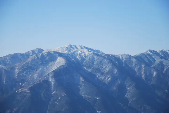
Mt. Takashiroyama (1,628 m) rises on the border between Naka Town in Naka County and Mima City in Tokushima Prefecture, along the east-north-east ridge running from Mt. Tsurugi past Mt. Ichinomori, midway between Tsurugi and Kumosō-yama. As part of Tsurugi-san Quasi-National Park, the surrounding 238-ha Forestry Agency Takashiroyama Recreational Forest is cloaked in beech wilderness up to the very summit, where a radar weather-observation station scans eastern Shikoku. The base lodge "Fagus-no-Mori" along the Tsurugi-san Super Forestry Road serves as the climbing hub.
Mt. Takashiroyama at a glance
- Weather: The most settled day in the next 7 days is Sun, November 8: clear, gusts up to 10 m/s. Fri, Nov 6, Sat, Nov 7: strong wind (gusts up to 18 m/s).
Mt. Takashiroyama weather (hourly, 14 days)
Sunrise today 06:23, sunset 17:10
| Tue, 11/3 | Wed, 11/4 | Thu, 11/5 | Fri, 11/6 | Sat, 11/7 | Sun, 11/8 | Mon, 11/9 | Tue, 11/10 | Wed, 11/11 | Thu, 11/12 | Fri, 11/13 | Sat, 11/14 | Sun, 11/15 | Mon, 11/16 | Tue, 11/17 | |||||||||||||||||||||||||||||||||||||||||||||||||||||||||||||||||||||||
|---|---|---|---|---|---|---|---|---|---|---|---|---|---|---|---|---|---|---|---|---|---|---|---|---|---|---|---|---|---|---|---|---|---|---|---|---|---|---|---|---|---|---|---|---|---|---|---|---|---|---|---|---|---|---|---|---|---|---|---|---|---|---|---|---|---|---|---|---|---|---|---|---|---|---|---|---|---|---|---|---|---|---|---|---|---|
| Japan time | 15 | 17 | 19 | 21 | 23 | 1 | 3 | 5 | 7 | 9 | 11 | 13 | 15 | 18 | 21 | 0 | 3 | 6 | 9 | 12 | 15 | 18 | 21 | 0 | 3 | 6 | 9 | 12 | 15 | 18 | 21 | 0 | 3 | 6 | 9 | 12 | 15 | 18 | 21 | 0 | 3 | 6 | 9 | 12 | 15 | 18 | 21 | 0 | 3 | 6 | 9 | 15 | 21 | 3 | 9 | 15 | 21 | 3 | 9 | 15 | 21 | 3 | 9 | 15 | 21 | 3 | 9 | 15 | 21 | 3 | 9 | 15 | 21 | 3 | 9 | 15 | 21 | 3 | 9 | 15 | 21 | 3 | 9 | 15 | |
 | |   |   | | | | |   | |   | |   | | |   | | |   | |   | |   | | |   | | | |  | | | | | | | | | | | | | | | | | | | | | | | | | | | | | | | | | | | |  | | | | | | | | | | | |   | |   | | | | | ||
| Temperature | °C | 8° | 5° | 3° | 3° | 4° | 3° | 4° | 3° | 3° | 5° | 7° | 8° | 8° | 6° | 6° | 6° | 8° | 7° | 9° | 11° | 13° | 8° | 8° | 10° | 8° | 5° | 7° | 10° | 9° | 4° | 2° | 0° | 0° | -1° | 1° | 3° | 4° | 0° | -2° | -3° | -4° | -3° | 3° | 6° | 5° | 0° | 2° | 0° | 1° | 1° | 5° | 7° | 0° | -1° | 4° | 6° | 0° | -2° | 0° | 2° | -2° | -5° | 2° | 6° | -2° | -1° | 3° | 3° | -2° | -4° | 4° | 7° | 0° | 1° | 7° | 8° | 7° | 5° | 7° | 8° | 2° | -1° | 1° | 5° |
| Precipitation | mm | 3.1 | 0.1 | 1.0 | 0.8 | 0.3 | 0.2 | 0.1 | 0.3 | 1.6 | 9 | 0.5 | 0.6 | 3.1 | 0.9 | ||||||||||||||||||||||||||||||||||||||||||||||||||||||||||||||||||||||
| New snow | cm | ||||||||||||||||||||||||||||||||||||||||||||||||||||||||||||||||||||||||||||||||||||
| Snow depth | cm | 0 | 0 | 0 | 0 | 0 | 0 | 0 | 0 | 0 | 0 | 0 | 0 | 0 | 0 | 0 | 0 | 0 | 0 | 0 | 0 | 0 | 0 | 0 | 0 | 0 | 0 | 0 | 0 | 0 | 0 | 0 | 0 | 0 | 0 | 0 | 0 | 0 | 0 | 0 | 0 | 0 | 0 | 0 | 0 | 0 | 0 | 0 | 0 | 0 | 0 | 0 | 0 | 0 | 0 | 0 | 0 | 0 | 0 | 0 | 0 | 0 | 0 | 0 | 0 | 0 | 0 | 0 | 0 | 0 | 0 | 0 | 0 | 0 | 0 | 0 | 0 | 0 | 0 | 0 | 0 | 0 | 0 | 0 | 0 |
| Wind | m/s | 4 | 2 | 2 | 2 | 2 | 3 | 3 | 3 | 3 | 3 | 2 | 1 | 1 | 1 | 1 | 2 | 0 | 1 | 0 | 1 | 2 | 2 | 2 | 3 | 3 | 5 | 5 | 5 | 4 | 3 | 5 | 6 | 5 | 5 | 6 | 5 | 5 | 4 | 3 | 2 | 2 | 2 | 3 | 3 | 3 | 1 | 1 | 1 | 1 | 2 | 3 | 4 | 2 | 1 | 2 | 3 | 5 | 8 | 7 | 6 | 3 | 2 | 1 | 1 | 2 | 4 | 6 | 6 | 3 | 2 | 1 | 2 | 1 | 1 | 4 | 4 | 4 | 2 | 5 | 5 | 5 | 3 | 3 | 3 |
| Wind gusts | m/s | 11 | 11 | 7 | 7 | 7 | 7 | 8 | 9 | 9 | 9 | 9 | 7 | 5 | 4 | 3 | 5 | 6 | 3 | 4 | 5 | 6 | 6 | 9 | 10 | 10 | 16 | 16 | 17 | 14 | 11 | 14 | 17 | 17 | 16 | 18 | 17 | 15 | 14 | 11 | 9 | 7 | 7 | 10 | 10 | 9 | 9 | 4 | 4 | 4 | 5 | 9 | 11 | 10 | 6 | 7 | 10 | 15 | 21 | 23 | 20 | 16 | 8 | 5 | 5 | 5 | 11 | 15 | 15 | 15 | 8 | 5 | 7 | 6 | 5 | 11 | 15 | 15 | 12 | 16 | 16 | 15 | 13 | 9 | 11 |
| Wind dir. | ↓ | ↓ | ↓ | ↓ | ↓ | ↓ | ↓ | ↓ | ↓ | ↓ | ↓ | ↓ | ↓ | ↓ | ↓ | ↓ | ↓ | ↓ | ↓ | ↓ | ↓ | ↓ | ↓ | ↓ | ↓ | ↓ | ↓ | ↓ | ↓ | ↓ | ↓ | ↓ | ↓ | ↓ | ↓ | ↓ | ↓ | ↓ | ↓ | ↓ | ↓ | ↓ | ↓ | ↓ | ↓ | ↓ | ↓ | ↓ | ↓ | ↓ | ↓ | ↓ | ↓ | ↓ | ↓ | ↓ | ↓ | ↓ | ↓ | ↓ | ↓ | ↓ | ↓ | ↓ | ↓ | ↓ | ↓ | ↓ | ↓ | ↓ | ↓ | ↓ | ↓ | ↓ | ↓ | ↓ | ↓ | ↓ | ↓ | ↓ | ↓ | ↓ | ↓ | ↓ | |
Huts, campsites and lodging near Mt. Takashiroyama
Mountain huts
- ファガスの森 高城
Campsites
- ファガスの森 キャンプ場
- 岳人の森キャンプ場
Lodging
- 四季美谷温泉
Lists that include Mt. Takashiroyama
Mt. Takashiroyama facts
- Also known as
- 高白山
- Elevation
- 1,628 m
- Location
- Naka-chō, Tokushima / Mima, Tokushima
33.891623, 134.239674 - National Park
- 剣山国定公園
- Website
- www.rinya.maff.go.jp
- Wikipedia
- ja.wikipedia.org