
Mt. Obora
大洞山
Tsu, Mie · Elevation 985 m
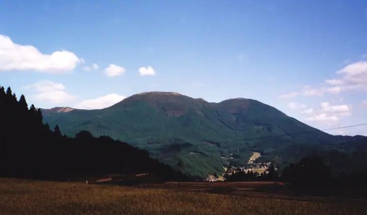
Mt. Obora is a 985 m peak in Misugi-cho, Tsu City, Mie, forming the southern of twin volcanic summits with the higher Odake (1,013 m) just to the north. This female peak is the lower of the pair and lies along a section of the Tokai Nature Trail, with alpine wildflowers coloring the gentle ridge through the seasons. The name is said to derive from the mountain's profile, likened to an inverted conch shell, and it is included in the Tsu 10, Mie prefectural, and Tokai-area guide lists.
Mt. Obora at a glance
- Weather: The most settled day in the next 7 days is Wed, November 4: cloudy, gusts up to 7 m/s. Fri, Nov 6, Sat, Nov 7: strong wind (gusts up to 19 m/s).
Mt. Obora weather (hourly, 14 days)
Sunrise today 06:17, sunset 17:01
| Tue, 11/3 | Wed, 11/4 | Thu, 11/5 | Fri, 11/6 | Sat, 11/7 | Sun, 11/8 | Mon, 11/9 | Tue, 11/10 | Wed, 11/11 | Thu, 11/12 | Fri, 11/13 | Sat, 11/14 | Sun, 11/15 | Mon, 11/16 | Tue, 11/17 | |||||||||||||||||||||||||||||||||||||||||||||||||||||||||||||||||||||||
|---|---|---|---|---|---|---|---|---|---|---|---|---|---|---|---|---|---|---|---|---|---|---|---|---|---|---|---|---|---|---|---|---|---|---|---|---|---|---|---|---|---|---|---|---|---|---|---|---|---|---|---|---|---|---|---|---|---|---|---|---|---|---|---|---|---|---|---|---|---|---|---|---|---|---|---|---|---|---|---|---|---|---|---|---|---|
| Japan time | 15 | 17 | 19 | 21 | 23 | 1 | 3 | 5 | 7 | 9 | 11 | 13 | 15 | 18 | 21 | 0 | 3 | 6 | 9 | 12 | 15 | 18 | 21 | 0 | 3 | 6 | 9 | 12 | 15 | 18 | 21 | 0 | 3 | 6 | 9 | 12 | 15 | 18 | 21 | 0 | 3 | 6 | 9 | 12 | 15 | 18 | 21 | 0 | 3 | 6 | 9 | 15 | 21 | 3 | 9 | 15 | 21 | 3 | 9 | 15 | 21 | 3 | 9 | 15 | 21 | 3 | 9 | 15 | 21 | 3 | 9 | 15 | 21 | 3 | 9 | 15 | 21 | 3 | 9 | 15 | 21 | 3 | 9 | 15 | |
  | |   |   | | | | | |   | | | |   | | | | |   |   | | |   | |   |   | | | | | |  | | | | | | | | | | | | | | | | | | |  | | |   | | | | | | | |  | | | | | |   | | | | | | | |   | | | | | | | | | ||
| Temperature | °C | 13° | 10° | 8° | 7° | 6° | 6° | 5° | 4° | 5° | 10° | 12° | 12° | 10° | 10° | 9° | 9° | 10° | 10° | 12° | 14° | 15° | 11° | 10° | 10° | 12° | 11° | 11° | 14° | 13° | 10° | 7° | 6° | 4° | 4° | 6° | 8° | 7° | 4° | 3° | 3° | 2° | 2° | 6° | 9° | 8° | 5° | 5° | 5° | 3° | 5° | 9° | 10° | 5° | 3° | 10° | 11° | 6° | 3° | 5° | 7° | 3° | 1° | 6° | 9° | 2° | 4° | 7° | 8° | 3° | 1° | 8° | 11° | 5° | 7° | 8° | 10° | 9° | 8° | 12° | 11° | 5° | 2° | 5° | 9° |
| Precipitation | mm | 0.1 | 0.6 | 0.5 | 0.2 | 0.2 | 1.5 | 0.3 | 0.7 | 0.7 | 0.1 | 0.3 | 0.2 | 0.1 | 0.7 | 0.5 | 1.4 | 13 | 1.4 | ||||||||||||||||||||||||||||||||||||||||||||||||||||||||||||||||||
| New snow | cm | ||||||||||||||||||||||||||||||||||||||||||||||||||||||||||||||||||||||||||||||||||||
| Snow depth | cm | 0 | 0 | 0 | 0 | 0 | 0 | 0 | 0 | 0 | 0 | 0 | 0 | 0 | 0 | 0 | 0 | 0 | 0 | 0 | 0 | 0 | 0 | 0 | 0 | 0 | 0 | 0 | 0 | 0 | 0 | 0 | 0 | 0 | 0 | 0 | 0 | 0 | 0 | 0 | 0 | 0 | 0 | 0 | 0 | 0 | 0 | 0 | 0 | 0 | 0 | 0 | 0 | 0 | 0 | 0 | 0 | 0 | 0 | 0 | 0 | 0 | 0 | 0 | 0 | 0 | 0 | 0 | 0 | 0 | 0 | 0 | 0 | 0 | 0 | 0 | 0 | 0 | 0 | 0 | 0 | 0 | 0 | 0 | 0 |
| Wind | m/s | 4 | 3 | 3 | 2 | 2 | 2 | 2 | 2 | 2 | 1 | 2 | 2 | 2 | 4 | 4 | 5 | 3 | 0 | 1 | 2 | 2 | 1 | 1 | 2 | 4 | 5 | 6 | 6 | 6 | 4 | 6 | 7 | 7 | 6 | 8 | 8 | 7 | 5 | 4 | 4 | 4 | 3 | 4 | 5 | 4 | 3 | 2 | 2 | 2 | 3 | 4 | 4 | 3 | 2 | 2 | 4 | 5 | 7 | 6 | 7 | 4 | 3 | 4 | 3 | 3 | 4 | 4 | 6 | 4 | 2 | 1 | 3 | 1 | 1 | 2 | 2 | 1 | 2 | 5 | 7 | 5 | 5 | 5 | 3 |
| Wind gusts | m/s | 10 | 9 | 7 | 7 | 6 | 5 | 5 | 5 | 4 | 4 | 6 | 6 | 7 | 9 | 11 | 11 | 11 | 7 | 4 | 6 | 6 | 5 | 3 | 6 | 10 | 15 | 15 | 15 | 15 | 14 | 14 | 16 | 17 | 16 | 19 | 19 | 18 | 17 | 13 | 10 | 9 | 8 | 10 | 12 | 12 | 11 | 8 | 5 | 5 | 7 | 11 | 12 | 10 | 7 | 6 | 11 | 10 | 18 | 18 | 19 | 17 | 10 | 9 | 10 | 9 | 10 | 11 | 15 | 15 | 10 | 6 | 9 | 8 | 3 | 5 | 8 | 6 | 7 | 11 | 16 | 16 | 12 | 12 | 12 |
| Wind dir. | ↓ | ↓ | ↓ | ↓ | ↓ | ↓ | ↓ | ↓ | ↓ | ↓ | ↓ | ↓ | ↓ | ↓ | ↓ | ↓ | ↓ | ↓ | ↓ | ↓ | ↓ | ↓ | ↓ | ↓ | ↓ | ↓ | ↓ | ↓ | ↓ | ↓ | ↓ | ↓ | ↓ | ↓ | ↓ | ↓ | ↓ | ↓ | ↓ | ↓ | ↓ | ↓ | ↓ | ↓ | ↓ | ↓ | ↓ | ↓ | ↓ | ↓ | ↓ | ↓ | ↓ | ↓ | ↓ | ↓ | ↓ | ↓ | ↓ | ↓ | ↓ | ↓ | ↓ | ↓ | ↓ | ↓ | ↓ | ↓ | ↓ | ↓ | ↓ | ↓ | ↓ | ↓ | ↓ | ↓ | ↓ | ↓ | ↓ | ↓ | ↓ | ↓ | ↓ | ↓ | |
Huts, campsites and lodging near Mt. Obora
Campsites
- スカイランドおおぼら
Lists that include Mt. Obora
Mt. Obora facts
- Also known as
- 雌岳
- Elevation
- 985 m
- Location
- Tsu, Mie
34.533465, 136.218367 - Website
- tsukanko.jp
- Trail Map
- www.info.city.tsu.mie.jp
- Access Information
- www.kankomie.or.jp
- Wikipedia
- ja.wikipedia.org