
Mt. Kabutodake
兜岳
Soni, Nara · Elevation 920 m
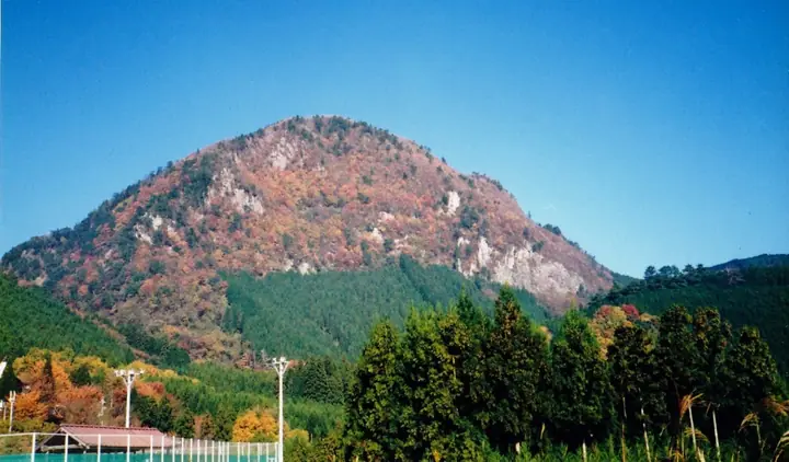
Mount Kabutodake (920 m) is one of the twin peaks of Soni Village in Uda District, Nara, set in Murō-Akame-Aoyama Quasi-National Park. Paired with Mount Yoroi-dake (the "armour mountain"), its rugged crags suggest a warrior's helmet, hence the name, and the peak is also called Me-dake ("female peak"). Both peaks were designated National Natural Monuments in December 1934 and form the centrepiece of the village's Kenkyaku Kigan-meguri ("strenuous strange-rocks") trail, included in the Nara 100 Mountains selection.
Mt. Kabutodake at a glance
- Weather: The most settled day in the next 7 days is Thu, November 5: cloudy, gusts up to 5 m/s. Fri, Nov 6, Sat, Nov 7: strong wind (gusts up to 18 m/s).
Mt. Kabutodake weather (hourly, 14 days)
Sunrise today 06:17, sunset 17:01
| Tue, 11/3 | Wed, 11/4 | Thu, 11/5 | Fri, 11/6 | Sat, 11/7 | Sun, 11/8 | Mon, 11/9 | Tue, 11/10 | Wed, 11/11 | Thu, 11/12 | Fri, 11/13 | Sat, 11/14 | Sun, 11/15 | Mon, 11/16 | Tue, 11/17 | |||||||||||||||||||||||||||||||||||||||||||||||||||||||||||||||||||||||
|---|---|---|---|---|---|---|---|---|---|---|---|---|---|---|---|---|---|---|---|---|---|---|---|---|---|---|---|---|---|---|---|---|---|---|---|---|---|---|---|---|---|---|---|---|---|---|---|---|---|---|---|---|---|---|---|---|---|---|---|---|---|---|---|---|---|---|---|---|---|---|---|---|---|---|---|---|---|---|---|---|---|---|---|---|---|
| Japan time | 21 | 23 | 1 | 3 | 5 | 7 | 9 | 11 | 13 | 15 | 17 | 19 | 21 | 0 | 3 | 6 | 9 | 12 | 15 | 18 | 21 | 0 | 3 | 6 | 9 | 12 | 15 | 18 | 21 | 0 | 3 | 6 | 9 | 12 | 15 | 18 | 21 | 0 | 3 | 6 | 9 | 12 | 15 | 18 | 21 | 0 | 3 | 6 | 9 | 12 | 15 | 21 | 3 | 9 | 15 | 21 | 3 | 9 | 15 | 21 | 3 | 9 | 15 | 21 | 3 | 9 | 15 | 21 | 3 | 9 | 15 | 21 | 3 | 9 | 15 | 21 | 3 | 9 | 15 | 21 | 3 | 9 | 15 | 21 | |
  |   | | | |   |   |   | | | |   | | |   | |   | | |   | | | |   |   | |   | | | | |  | | | | | | | | | | |  | | | | | | | | | |   | | | | | | | |  | | | | | | | | | | | | | | | | | | | | | | |  | ||
| Temperature | °C | 8° | 7° | 6° | 5° | 5° | 7° | 9° | 13° | 12° | 11° | 10° | 10° | 10° | 10° | 10° | 10° | 12° | 16° | 18° | 12° | 11° | 11° | 12° | 10° | 11° | 14° | 13° | 10° | 7° | 6° | 5° | 4° | 7° | 8° | 7° | 5° | 3° | 3° | 3° | 2° | 5° | 9° | 9° | 4° | 5° | 5° | 6° | 6° | 8° | 11° | 11° | 5° | 4° | 10° | 11° | 6° | 3° | 5° | 7° | 2° | 0° | 6° | 9° | 3° | 4° | 7° | 8° | 3° | 1° | 8° | 13° | 5° | 7° | 9° | 11° | 9° | 10° | 12° | 12° | 5° | 2° | 5° | 9° | 2° |
| Precipitation | mm | 0.2 | 0.1 | 0.2 | 0.2 | 1.2 | 0.3 | 0.4 | 2.2 | 0.7 | 0.4 | 1.4 | 0.2 | 0.2 | 0.1 | 0.2 | 0.9 | 0.2 | 0.7 | 11 | 0.4 | 1.7 | 0.3 | ||||||||||||||||||||||||||||||||||||||||||||||||||||||||||||||
| New snow | cm | ||||||||||||||||||||||||||||||||||||||||||||||||||||||||||||||||||||||||||||||||||||
| Snow depth | cm | 0 | 0 | 0 | 0 | 0 | 0 | 0 | 0 | 0 | 0 | 0 | 0 | 0 | 0 | 0 | 0 | 0 | 0 | 0 | 0 | 0 | 0 | 0 | 0 | 0 | 0 | 0 | 0 | 0 | 0 | 0 | 0 | 0 | 0 | 0 | 0 | 0 | 0 | 0 | 0 | 0 | 0 | 0 | 0 | 0 | 0 | 0 | 0 | 0 | 0 | 0 | 0 | 0 | 0 | 0 | 0 | 0 | 0 | 0 | 0 | 0 | 0 | 0 | 0 | 0 | 0 | 0 | 0 | 0 | 0 | 0 | 0 | 0 | 0 | 0 | 0 | 0 | 0 | 0 | 0 | 0 | 0 | 0 | 0 |
| Wind | m/s | 2 | 1 | 2 | 1 | 1 | 1 | 1 | 2 | 3 | 4 | 4 | 5 | 5 | 4 | 3 | 1 | 2 | 1 | 1 | 1 | 2 | 2 | 5 | 5 | 6 | 6 | 6 | 5 | 5 | 6 | 6 | 5 | 8 | 7 | 7 | 5 | 4 | 4 | 3 | 3 | 4 | 4 | 3 | 2 | 0 | 0 | 1 | 2 | 3 | 4 | 4 | 2 | 2 | 3 | 4 | 4 | 7 | 6 | 7 | 3 | 2 | 3 | 3 | 2 | 4 | 4 | 6 | 2 | 1 | 1 | 2 | 1 | 1 | 3 | 3 | 1 | 3 | 4 | 7 | 4 | 4 | 4 | 3 | 1 |
| Wind gusts | m/s | 5 | 4 | 4 | 4 | 4 | 3 | 4 | 6 | 8 | 9 | 10 | 12 | 14 | 13 | 9 | 6 | 5 | 5 | 3 | 5 | 4 | 6 | 12 | 13 | 13 | 15 | 16 | 15 | 12 | 14 | 14 | 14 | 18 | 18 | 18 | 17 | 12 | 10 | 9 | 8 | 9 | 11 | 10 | 7 | 3 | 3 | 3 | 6 | 7 | 11 | 10 | 9 | 6 | 7 | 11 | 10 | 16 | 16 | 18 | 16 | 7 | 8 | 10 | 8 | 9 | 10 | 14 | 14 | 6 | 4 | 8 | 7 | 3 | 7 | 10 | 8 | 7 | 11 | 16 | 16 | 11 | 10 | 9 | 7 |
| Wind dir. | ↓ | ↓ | ↓ | ↓ | ↓ | ↓ | ↓ | ↓ | ↓ | ↓ | ↓ | ↓ | ↓ | ↓ | ↓ | ↓ | ↓ | ↓ | ↓ | ↓ | ↓ | ↓ | ↓ | ↓ | ↓ | ↓ | ↓ | ↓ | ↓ | ↓ | ↓ | ↓ | ↓ | ↓ | ↓ | ↓ | ↓ | ↓ | ↓ | ↓ | ↓ | ↓ | ↓ | ↓ | ↓ | ↓ | ↓ | ↓ | ↓ | ↓ | ↓ | ↓ | ↓ | ↓ | ↓ | ↓ | ↓ | ↓ | ↓ | ↓ | ↓ | ↓ | ↓ | ↓ | ↓ | ↓ | ↓ | ↓ | ↓ | ↓ | ↓ | ↓ | ↓ | ↓ | ↓ | ↓ | ↓ | ↓ | ↓ | ↓ | ↓ | ↓ | ↓ | ↓ | |
Huts, campsites and lodging near Mt. Kabutodake
Campsites
- Sun Village Soni
- Kotaroiwa Camping Ground
Lodging
- Minshuku 2.7
- 民宿 豊栄
- そに木霊リゾート~垰tawa~
- Kijiya
- 紅葉亭
Lists that include Mt. Kabutodake
Mt. Kabutodake facts
- Also known as
- 女岳
- Elevation
- 920 m
- Location
- Soni, Nara
34.525806, 136.120573 - National Park
- 室生赤目青山国定公園
- Website
- sonimura.com