
Mt. Takami
高見山
Higashiyoshino, Nara / Matsusaka, Mie · Elevation 1,248 m
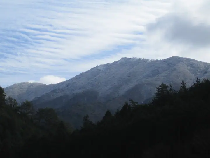
Takamiyama is a 1,248 m peak straddling the boundary between Matsusaka City in Mie Prefecture and Higashiyoshino Village in Nara Prefecture, at the northern end of the Daikō Range. Its sharp triangular profile has earned it the nickname "Matterhorn of Kansai," and from late December to late February the summit ridge is famed for its rime-ice (muhyō) — one of the most celebrated winter scenes in the Kinki region. Takasumi Shrine sits at the summit, and the mountain lies within Muro-Akame-Aoyama Quasi-National Park. It is listed in the Japanese 300 Famous Mountains, the Kansai 100, and the Kinki 100, among others.
Mt. Takami at a glance
- Weather: The most settled day in the next 7 days is Sun, November 8: cloudy, gusts up to 10 m/s. Sat, Nov 7: strong wind (gusts up to 17 m/s).
- Route: The shortest is Mount Takami Return from Takami Pass: about 1 h 32 min, 1.8 km, about 350 m of climbing.
Mt. Takami weather (hourly, 14 days)
Sunrise today 06:17, sunset 17:02
| Tue, 11/3 | Wed, 11/4 | Thu, 11/5 | Fri, 11/6 | Sat, 11/7 | Sun, 11/8 | Mon, 11/9 | Tue, 11/10 | Wed, 11/11 | Thu, 11/12 | Fri, 11/13 | Sat, 11/14 | Sun, 11/15 | Mon, 11/16 | Tue, 11/17 | |||||||||||||||||||||||||||||||||||||||||||||||||||||||||||||||||||||||
|---|---|---|---|---|---|---|---|---|---|---|---|---|---|---|---|---|---|---|---|---|---|---|---|---|---|---|---|---|---|---|---|---|---|---|---|---|---|---|---|---|---|---|---|---|---|---|---|---|---|---|---|---|---|---|---|---|---|---|---|---|---|---|---|---|---|---|---|---|---|---|---|---|---|---|---|---|---|---|---|---|---|---|---|---|---|
| Japan time | 15 | 17 | 19 | 21 | 23 | 1 | 3 | 5 | 7 | 9 | 11 | 13 | 15 | 18 | 21 | 0 | 3 | 6 | 9 | 12 | 15 | 18 | 21 | 0 | 3 | 6 | 9 | 12 | 15 | 18 | 21 | 0 | 3 | 6 | 9 | 12 | 15 | 18 | 21 | 0 | 3 | 6 | 9 | 12 | 15 | 18 | 21 | 0 | 3 | 6 | 9 | 15 | 21 | 3 | 9 | 15 | 21 | 3 | 9 | 15 | 21 | 3 | 9 | 15 | 21 | 3 | 9 | 15 | 21 | 3 | 9 | 15 | 21 | 3 | 9 | 15 | 21 | 3 | 9 | 15 | 21 | 3 | 9 | 15 | |
  | |   | | | | | |   | |   | | |   | | | | | |   | |   |   | | | |   | | |   | | |  | | | | | | | | | | | | | | | |   | |  | |   | | | | | | | | |  | | | | | | | | | | | | | | | | | | | | | | | ||
| Temperature | °C | 11° | 7° | 6° | 5° | 4° | 4° | 3° | 3° | 4° | 9° | 12° | 11° | 10° | 8° | 8° | 9° | 9° | 8° | 12° | 14° | 15° | 10° | 9° | 9° | 10° | 10° | 9° | 12° | 10° | 9° | 5° | 4° | 2° | 2° | 4° | 6° | 6° | 2° | 1° | 0° | 0° | 0° | 5° | 7° | 7° | 2° | 3° | 3° | 2° | 3° | 7° | 8° | 3° | 2° | 7° | 9° | 3° | 1° | 3° | 5° | 0° | -2° | 4° | 6° | 0° | 1° | 4° | 6° | -1° | -2° | 6° | 11° | 1° | 3° | 8° | 10° | 8° | 9° | 10° | 10° | 3° | 0° | 3° | 6° |
| Precipitation | mm | 0.2 | 0.4 | 0.1 | 0.2 | 0.2 | 1.4 | 2.5 | 1.4 | 0.2 | 1.2 | 1.0 | 0.2 | 0.1 | 0.3 | 0.2 | 0.2 | 0.8 | 0.1 | 0.6 | 0.7 | 1.3 | 14 | 1.0 | 3.4 | 0.7 | |||||||||||||||||||||||||||||||||||||||||||||||||||||||||||
| New snow | cm | ||||||||||||||||||||||||||||||||||||||||||||||||||||||||||||||||||||||||||||||||||||
| Snow depth | cm | 0 | 0 | 0 | 0 | 0 | 0 | 0 | 0 | 0 | 0 | 0 | 0 | 0 | 0 | 0 | 0 | 0 | 0 | 0 | 0 | 0 | 0 | 0 | 0 | 0 | 0 | 0 | 0 | 0 | 0 | 0 | 0 | 0 | 0 | 0 | 0 | 0 | 0 | 0 | 0 | 0 | 0 | 0 | 0 | 0 | 0 | 0 | 0 | 0 | 0 | 0 | 0 | 0 | 0 | 0 | 0 | 0 | 0 | 0 | 0 | 0 | 0 | 0 | 0 | 0 | 0 | 0 | 0 | 0 | 0 | 0 | 0 | 0 | 0 | 0 | 0 | 0 | 0 | 0 | 0 | 0 | 0 | 0 | 0 |
| Wind | m/s | 3 | 2 | 1 | 1 | 1 | 1 | 1 | 1 | 1 | 1 | 3 | 4 | 4 | 5 | 5 | 4 | 3 | 2 | 1 | 2 | 1 | 1 | 2 | 3 | 3 | 5 | 5 | 6 | 6 | 5 | 5 | 5 | 5 | 5 | 7 | 7 | 6 | 5 | 3 | 2 | 2 | 2 | 3 | 3 | 3 | 1 | 1 | 1 | 1 | 2 | 3 | 3 | 1 | 1 | 2 | 4 | 4 | 6 | 5 | 6 | 2 | 2 | 2 | 3 | 1 | 3 | 3 | 5 | 1 | 0 | 1 | 0 | 1 | 1 | 3 | 3 | 2 | 3 | 4 | 6 | 4 | 3 | 2 | 3 |
| Wind gusts | m/s | 8 | 8 | 4 | 3 | 3 | 3 | 4 | 3 | 3 | 5 | 7 | 9 | 10 | 13 | 13 | 13 | 10 | 7 | 5 | 5 | 5 | 3 | 4 | 7 | 10 | 12 | 13 | 14 | 15 | 14 | 12 | 13 | 14 | 13 | 16 | 17 | 16 | 15 | 11 | 8 | 7 | 6 | 8 | 10 | 9 | 7 | 3 | 3 | 3 | 5 | 7 | 11 | 8 | 4 | 7 | 11 | 10 | 14 | 15 | 18 | 15 | 6 | 6 | 9 | 8 | 8 | 9 | 14 | 13 | 4 | 5 | 6 | 4 | 4 | 7 | 10 | 7 | 9 | 10 | 15 | 14 | 9 | 8 | 8 |
| Wind dir. | ↓ | ↓ | ↓ | ↓ | ↓ | ↓ | ↓ | ↓ | ↓ | ↓ | ↓ | ↓ | ↓ | ↓ | ↓ | ↓ | ↓ | ↓ | ↓ | ↓ | ↓ | ↓ | ↓ | ↓ | ↓ | ↓ | ↓ | ↓ | ↓ | ↓ | ↓ | ↓ | ↓ | ↓ | ↓ | ↓ | ↓ | ↓ | ↓ | ↓ | ↓ | ↓ | ↓ | ↓ | ↓ | ↓ | ↓ | ↓ | ↓ | ↓ | ↓ | ↓ | ↓ | ↓ | ↓ | ↓ | ↓ | ↓ | ↓ | ↓ | ↓ | ↓ | ↓ | ↓ | ↓ | ↓ | ↓ | ↓ | ↓ | ↓ | ↓ | ↓ | ↓ | ↓ | ↓ | ↓ | ↓ | ↓ | ↓ | ↓ | ↓ | ↓ | ↓ | ↓ | |
Mt. Takami hiking routes
- Mount Takami Return from Takami Pass 1.8 km · Ascent 349 m 高見山登山口駐車場
- Higashiyoshino Mount Takami from the Ise Minami Kaido Stone Path by Kunimi Rock to Takamisugi and Hirano 7.6 km · Ascent 817 m たかすみの里 (parking)
- Takamiyama from Takasumi Onsen 8.9 km · Ascent 851 m たかすみの里 (parking)
Hiking times are estimates calculated from the terrain.
Huts, campsites and lodging near Mt. Takami
Mountain huts
Lodging
- あまご池 高見山荘
Lists that include Mt. Takami
Japan's 300 Famous Mountains · Illustrated Collection of Japan's Famous Mountains · Kansai 100 Famous Mountains · Tokai 100 Mountains · Kinki 100 Famous Mountains · Nara 100 Mountains to Explore · Matsusaka Kahada 11 · Elevations of 1003 Mountains of Japan · 1000 Mountains of Japan
Mt. Takami facts
- Elevation
- 1,248 m
- Location
- Higashiyoshino, Nara / Matsusaka, Mie
34.428713, 136.088430 - National Park
- 室生赤目青山国定公園
- Website
- www.pref.nara.lg.jp
- Trail Map
- www.pref.nara.lg.jp (PDF)
- Access Information
- www.pref.nara.lg.jp
- Wikipedia
- ja.wikipedia.org