
Mt. Kushigamine
櫛ヶ峰
Hirakawa, Aomori · Elevation 1,516 m
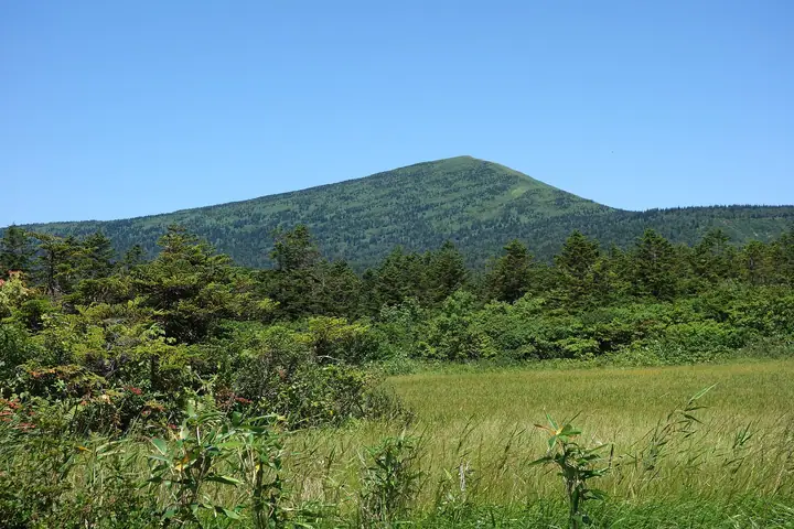
Mt. Kushigamine is a 1,516-meter volcano on the border of Aomori, Kuroishi, and Hirakawa cities in Aomori Prefecture — the highest peak of the southern Hakkoda range. Locally called Kamidake ("upper peak") in contrast to its neighbour Shimodake, the mountain takes its name from the ridge profile that resembles a boxwood comb when seen from the east. It lies within Towada-Hachimantai National Park, surrounded by extensive wetlands and alpine flower meadows. The standard route from Sarukura Onsen runs roughly ten hours round trip with no shelters or campsites, making it a long, demanding outing for experienced hikers.
Mt. Kushigamine at a glance
- Weather: The most settled day in the next 7 days is Thu, November 5: cloudy, gusts up to 9 m/s. Wed, Nov 4, Fri, Nov 6, Sat, Nov 7, Sun, Nov 8: strong wind (gusts up to 27 m/s).
Mt. Kushigamine weather (hourly, 14 days)
Sunrise today 06:08, sunset 16:32
| Tue, 11/3 | Wed, 11/4 | Thu, 11/5 | Fri, 11/6 | Sat, 11/7 | Sun, 11/8 | Mon, 11/9 | Tue, 11/10 | Wed, 11/11 | Thu, 11/12 | Fri, 11/13 | Sat, 11/14 | Sun, 11/15 | Mon, 11/16 | Tue, 11/17 | |||||||||||||||||||||||||||||||||||||||||||||||||||||||||||||||||||||||
|---|---|---|---|---|---|---|---|---|---|---|---|---|---|---|---|---|---|---|---|---|---|---|---|---|---|---|---|---|---|---|---|---|---|---|---|---|---|---|---|---|---|---|---|---|---|---|---|---|---|---|---|---|---|---|---|---|---|---|---|---|---|---|---|---|---|---|---|---|---|---|---|---|---|---|---|---|---|---|---|---|---|---|---|---|---|
| Japan time | 15 | 17 | 19 | 21 | 23 | 1 | 3 | 5 | 7 | 9 | 11 | 13 | 15 | 18 | 21 | 0 | 3 | 6 | 9 | 12 | 15 | 18 | 21 | 0 | 3 | 6 | 9 | 12 | 15 | 18 | 21 | 0 | 3 | 6 | 9 | 12 | 15 | 18 | 21 | 0 | 3 | 6 | 9 | 12 | 15 | 18 | 21 | 0 | 3 | 6 | 9 | 15 | 21 | 3 | 9 | 15 | 21 | 3 | 9 | 15 | 21 | 3 | 9 | 15 | 21 | 3 | 9 | 15 | 21 | 3 | 9 | 15 | 21 | 3 | 9 | 15 | 21 | 3 | 9 | 15 | 21 | 3 | 9 | 15 | |
  |   |   | |  | |   |   |   | |  | | | | | | |   |   |   |   |   | | |   | | | | | | |   |   | |   | | | | | | | |   | | | | | | | | | | | |   |   | | | | | | | | | | | | | | | | |  | | | | | | |   | | | | | ||
| Temperature | °C | 0° | -2° | -2° | -2° | -2° | -1° | 1° | 0° | 0° | 3° | 4° | 4° | 4° | 0° | -1° | 0° | 1° | 2° | 6° | 7° | 6° | 5° | 5° | 5° | 5° | 5° | 8° | 8° | 4° | 0° | -2° | -5° | -5° | -6° | -4° | -4° | -4° | -6° | -6° | -6° | -6° | -6° | -4° | -3° | -4° | -5° | -5° | -5° | -6° | -6° | -5° | -5° | -6° | -7° | -4° | -3° | -4° | -3° | -4° | -3° | -4° | -5° | -1° | -1° | -4° | -5° | -4° | -4° | -8° | -9° | -2° | 0° | -6° | -6° | 3° | 3° | 1° | 0° | 1° | -3° | -6° | -6° | -3° | -2° |
| Precipitation | mm | 0.2 | 0.4 | 0.4 | 0.2 | 0.3 | 1.7 | 5 | 3.8 | 0.3 | 0.1 | 3.1 | 2.3 | 0.4 | 0.1 | 0.3 | 0.7 | 1.0 | 1.7 | 1.7 | 1.9 | 1.4 | 1.1 | 0.9 | 0.7 | 0.3 | 0.1 | 0.2 | 0.3 | 0.3 | 1.5 | 0.3 | 0.2 | 0.2 | 3.2 | 13 | 20 | 3.1 | 0.3 | 0.4 | 1.7 | 2.7 | 0.3 | 0.9 | 0.3 | 1.2 | 3.7 | 1.1 | 6 | 2.5 | 0.4 | ||||||||||||||||||||||||||||||||||
| New snow | cm | <.1 | <.1 | <.1 | 0.3 | 0.7 | 1.0 | 1.7 | 1.7 | 1.9 | 1.4 | 1.1 | 0.9 | 0.7 | 0.3 | 0.1 | <.1 | 0.2 | 0.3 | 0.3 | 1.4 | 0.3 | 0.2 | 0.1 | 3.2 | 12 | 19 | 2.9 | <.1 | <.1 | 0.2 | 1.4 | 2.4 | 0.3 | 0.9 | 0.3 | 1.5 | 2.4 | 0.4 | ||||||||||||||||||||||||||||||||||||||||||||||
| Snow depth | cm | 0 | 0 | 0 | 0 | 0 | 0 | 0 | 0 | 0 | 0 | 0 | 0 | 0 | 0 | 0 | 0 | 0 | 0 | 0 | 0 | 0 | 0 | 0 | 0 | 0 | 0 | 0 | 0 | 0 | 0 | 0 | 0 | 0 | <1 | 1 | 2 | 3 | 4 | 5 | 6 | 6 | 7 | 7 | 7 | 6 | 6 | 6 | 6 | 6 | 6 | 7 | 7 | 7 | 7 | 7 | 6 | 8 | 16 | 28 | 28 | 27 | 27 | 26 | 24 | 25 | 27 | 26 | 26 | 26 | 26 | 25 | 24 | 24 | 23 | 23 | 20 | 19 | 16 | 15 | 14 | 15 | 15 | 15 | 14 |
| Wind | m/s | 6 | 4 | 4 | 4 | 4 | 5 | 6 | 5 | 5 | 6 | 4 | 3 | 2 | 2 | 2 | 1 | 1 | 1 | 2 | 2 | 1 | 1 | 1 | 1 | 2 | 2 | 4 | 6 | 7 | 7 | 8 | 7 | 7 | 8 | 7 | 8 | 7 | 7 | 7 | 7 | 7 | 7 | 8 | 9 | 8 | 6 | 5 | 3 | 3 | 2 | 4 | 4 | 2 | 1 | 0 | 3 | 6 | 4 | 4 | 2 | 2 | 2 | 5 | 4 | 2 | 2 | 4 | 5 | 1 | 1 | 2 | 2 | 1 | 1 | 1 | 1 | 3 | 1 | 1 | 5 | 4 | 3 | 2 | 3 |
| Wind gusts | m/s | 21 | 19 | 14 | 13 | 13 | 16 | 20 | 20 | 18 | 17 | 17 | 13 | 9 | 7 | 8 | 6 | 5 | 7 | 9 | 8 | 7 | 5 | 5 | 4 | 7 | 8 | 13 | 21 | 22 | 22 | 24 | 24 | 22 | 23 | 25 | 27 | 27 | 26 | 23 | 23 | 23 | 24 | 24 | 26 | 27 | 24 | 19 | 15 | 12 | 11 | 12 | 12 | 12 | 7 | 5 | 10 | 19 | 18 | 15 | 16 | 6 | 8 | 14 | 16 | 12 | 8 | 13 | 17 | 13 | 7 | 7 | 8 | 6 | 6 | 6 | 6 | 10 | 12 | 6 | 16 | 16 | 13 | 10 | 11 |
| Wind dir. | ↓ | ↓ | ↓ | ↓ | ↓ | ↓ | ↓ | ↓ | ↓ | ↓ | ↓ | ↓ | ↓ | ↓ | ↓ | ↓ | ↓ | ↓ | ↓ | ↓ | ↓ | ↓ | ↓ | ↓ | ↓ | ↓ | ↓ | ↓ | ↓ | ↓ | ↓ | ↓ | ↓ | ↓ | ↓ | ↓ | ↓ | ↓ | ↓ | ↓ | ↓ | ↓ | ↓ | ↓ | ↓ | ↓ | ↓ | ↓ | ↓ | ↓ | ↓ | ↓ | ↓ | ↓ | ↓ | ↓ | ↓ | ↓ | ↓ | ↓ | ↓ | ↓ | ↓ | ↓ | ↓ | ↓ | ↓ | ↓ | ↓ | ↓ | ↓ | ↓ | ↓ | ↓ | ↓ | ↓ | ↓ | ↓ | ↓ | ↓ | ↓ | ↓ | ↓ | ↓ | |
Lists that include Mt. Kushigamine
Tohoku 100 Famous Mountains · 110 Mountains of Aomori · Elevations of 1003 Mountains of Japan · 1000 Mountains of Japan
Mt. Kushigamine facts
- Also known as
- 上岳
- Elevation
- 1,516 m
- Location
- Hirakawa, Aomori
40.603201, 140.842586 - National Park
- 十和田八幡平国立公園
- Website
- hirakawa-kankou.com
- Wikipedia
- ja.wikipedia.org