
Mt. Kitatottabetsudake
北戸蔦別岳
Biratori, Hokkaido / Hidaka, Hokkaido / Obihiro, Hokkaido · Elevation 1,912 m
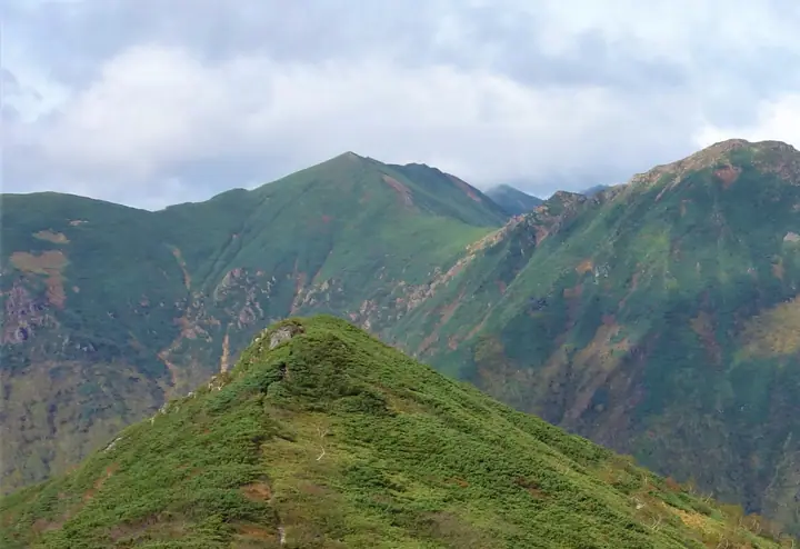
Mt. Kitatottabetsudake is a 1,912 m peak straddling Obihiro City, Hidaka Town, and Biratori Town (Saru District) in Hokkaido, on the central main ridge of the Hidaka Mountains north of Tottabetsudake and between Mt. Horoshiri and the 1967-meter peak/Pipairo-dake. It lies within Hidakasanmyaku-Erimo-Tokachi National Park, designated in 2024. The standard route enters from the Chiroro forest road on the Hidaka side, starting at the HEPCO water-intake dam and climbing via Nukabiradake; an entry permit must be filed with the North Hidaka Forest Management Office. The peak is included in the Hokkaido 100 Mountains.
Mt. Kitatottabetsudake at a glance
- Weather: The most settled day in the next 7 days is Mon, November 9: cloudy, gusts up to 12 m/s. Wed, Nov 4, Fri, Nov 6, Sat, Nov 7, Sun, Nov 8: strong wind (gusts up to 24 m/s).
Mt. Kitatottabetsudake weather (hourly, 14 days)
Sunrise today 06:05, sunset 16:21
| Tue, 11/3 | Wed, 11/4 | Thu, 11/5 | Fri, 11/6 | Sat, 11/7 | Sun, 11/8 | Mon, 11/9 | Tue, 11/10 | Wed, 11/11 | Thu, 11/12 | Fri, 11/13 | Sat, 11/14 | Sun, 11/15 | Mon, 11/16 | Tue, 11/17 | |||||||||||||||||||||||||||||||||||||||||||||||||||||||||||||||||||||
|---|---|---|---|---|---|---|---|---|---|---|---|---|---|---|---|---|---|---|---|---|---|---|---|---|---|---|---|---|---|---|---|---|---|---|---|---|---|---|---|---|---|---|---|---|---|---|---|---|---|---|---|---|---|---|---|---|---|---|---|---|---|---|---|---|---|---|---|---|---|---|---|---|---|---|---|---|---|---|---|---|---|---|---|
| Japan time | 21 | 23 | 1 | 3 | 5 | 7 | 9 | 11 | 13 | 15 | 17 | 19 | 21 | 0 | 3 | 6 | 9 | 12 | 15 | 18 | 21 | 0 | 3 | 6 | 9 | 12 | 15 | 18 | 21 | 0 | 3 | 6 | 9 | 12 | 15 | 18 | 21 | 0 | 3 | 6 | 9 | 12 | 15 | 18 | 21 | 0 | 3 | 6 | 9 | 15 | 21 | 3 | 9 | 15 | 21 | 3 | 9 | 15 | 21 | 3 | 9 | 15 | 21 | 3 | 9 | 15 | 21 | 3 | 9 | 15 | 21 | 3 | 9 | 15 | 21 | 3 | 9 | 15 | 21 | 3 | 9 | 15 | |
  | |   | |   |   | |   |  | |  | | |   | |   |   |   | | |   | | | | | | | | |   | | | | | | | | | | | | | | | | | | | | | | |   | | | | | | | | | | | | | | | | | |  | | | | | |   | | | | |   | ||
| Temperature | °C | -9° | -11° | -8° | -7° | -7° | -8° | -7° | -6° | -5° | -6° | -11° | -9° | -9° | -9° | -7° | -5° | 0° | 1° | 0° | -1° | 0° | -1° | -1° | -1° | 2° | 2° | 0° | -2° | -6° | -9° | -11° | -12° | -11° | -10° | -11° | -12° | -12° | -12° | -12° | -12° | -11° | -10° | -10° | -11° | -11° | -12° | -13° | -12° | -11° | -11° | -14° | -14° | -11° | -8° | -11° | -10° | -9° | -6° | -11° | -14° | -9° | -8° | -13° | -12° | -13° | -12° | -11° | -14° | -8° | -6° | -10° | -9° | -3° | -3° | -3° | -4° | -3° | -7° | -12° | -12° | -9° | -8° |
| Precipitation | mm | 0.9 | 4.1 | 0.2 | 0.2 | 0.2 | 0.2 | 1.3 | 2.7 | 1.2 | 1.3 | 6 | 2.0 | 0.8 | 2.5 | 0.4 | 0.3 | 0.5 | 0.1 | 0.1 | 1.0 | 1.1 | 0.2 | 0.2 | 0.5 | 0.5 | 0.4 | 0.4 | 0.3 | 0.5 | 0.5 | 0.2 | 2.9 | 3.2 | 0.4 | 0.2 | 1.2 | 0.2 | 0.2 | 0.2 | 0.1 | 0.3 | 0.3 | 7 | 1.8 | 1.3 | 1.9 | 0.3 | |||||||||||||||||||||||||||||||||||
| New snow | cm | 0.3 | 3.2 | 0.6 | <.1 | 0.2 | <.1 | – | – | 0.1 | 0.3 | 0.5 | <.1 | 0.1 | 1.0 | 1.1 | 0.2 | 0.2 | 0.5 | 0.5 | 0.4 | 0.4 | 0.3 | 0.5 | 0.5 | 0.2 | <.1 | 0.1 | <.1 | <.1 | 2.9 | 3.2 | 0.4 | 0.2 | 1.2 | 0.2 | <.1 | 0.2 | 0.1 | 0.1 | <.1 | 0.4 | <.1 | 1.7 | 0.3 | <.1 | |||||||||||||||||||||||||||||||||||||
| Snow depth | cm | 3 | 3 | 3 | 5 | 5 | 5 | 5 | 5 | 5 | 5 | 5 | 5 | 5 | 5 | 5 | 5 | 5 | 3 | 2 | 2 | 2 | 2 | 2 | <1 | <1 | <1 | <1 | 0 | <1 | <1 | <1 | <1 | <1 | 2 | 2 | 3 | 3 | 3 | 3 | 4 | 4 | 4 | 4 | 4 | 4 | 4 | 4 | 4 | 4 | 4 | 4 | 4 | 4 | 4 | 4 | 6 | 9 | 9 | 8 | 8 | 8 | 9 | 9 | 9 | 9 | 8 | 9 | 8 | 8 | 8 | 8 | 8 | 8 | 6 | 6 | 5 | 5 | 6 | 6 | 6 | 6 | 6 |
| Wind | m/s | 3 | 2 | 4 | 4 | 5 | 6 | 5 | 4 | 3 | 1 | 0 | 1 | 2 | 2 | 2 | 3 | 3 | 2 | 2 | 1 | 2 | 1 | 1 | 1 | 3 | 4 | 5 | 7 | 7 | 7 | 7 | 5 | 6 | 8 | 7 | 6 | 6 | 6 | 7 | 7 | 7 | 7 | 6 | 5 | 4 | 3 | 2 | 1 | 2 | 4 | 1 | 1 | 1 | 1 | 1 | 3 | 2 | 1 | 1 | 0 | 2 | 3 | 1 | 2 | 5 | 4 | 3 | 1 | 2 | 1 | 1 | 0 | 2 | 2 | 3 | 1 | 1 | 3 | 3 | 3 | 2 | 1 |
| Wind gusts | m/s | 10 | 10 | 14 | 15 | 16 | 17 | 17 | 15 | 12 | 10 | 6 | 6 | 7 | 8 | 10 | 10 | 12 | 12 | 10 | 8 | 6 | 6 | 5 | 6 | 10 | 14 | 15 | 21 | 21 | 23 | 23 | 21 | 21 | 24 | 23 | 21 | 20 | 22 | 22 | 21 | 22 | 21 | 21 | 19 | 16 | 13 | 11 | 8 | 8 | 12 | 11 | 6 | 6 | 6 | 5 | 11 | 10 | 6 | 4 | 4 | 7 | 10 | 10 | 9 | 15 | 15 | 13 | 12 | 9 | 7 | 6 | 5 | 9 | 11 | 11 | 11 | 7 | 10 | 11 | 11 | 10 | 8 |
| Wind dir. | ↓ | ↓ | ↓ | ↓ | ↓ | ↓ | ↓ | ↓ | ↓ | ↓ | ↓ | ↓ | ↓ | ↓ | ↓ | ↓ | ↓ | ↓ | ↓ | ↓ | ↓ | ↓ | ↓ | ↓ | ↓ | ↓ | ↓ | ↓ | ↓ | ↓ | ↓ | ↓ | ↓ | ↓ | ↓ | ↓ | ↓ | ↓ | ↓ | ↓ | ↓ | ↓ | ↓ | ↓ | ↓ | ↓ | ↓ | ↓ | ↓ | ↓ | ↓ | ↓ | ↓ | ↓ | ↓ | ↓ | ↓ | ↓ | ↓ | ↓ | ↓ | ↓ | ↓ | ↓ | ↓ | ↓ | ↓ | ↓ | ↓ | ↓ | ↓ | ↓ | ↓ | ↓ | ↓ | ↓ | ↓ | ↓ | ↓ | ↓ | ↓ | ↓ | |
Huts, campsites and lodging near Mt. Kitatottabetsudake
Mountain huts
Lists that include Mt. Kitatottabetsudake
Mt. Kitatottabetsudake facts
- Elevation
- 1,912 m
- Location
- Biratori, Hokkaido / Hidaka, Hokkaido / Obihiro, Hokkaido
42.750439, 142.687077 - National Park
- 日高山脈襟裳十勝国立公園
- Website
- hokkaido-hidaka-kankonavi.com
- Access Information
- www.town.hidaka.hokkaido.jp
- Wikipedia
- en.wikipedia.org