
Mt. Kabuto
兜山
Fuefuki, Yamanashi · Elevation 913 m
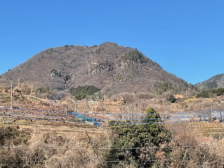
Mt. Kabuto (913 m) sits on the border of Fuefuki's Kasugai-chō and Yamanashi City along the north-eastern rim of the Kōfu Basin, listed among the 100 Famous Mountains of Yamanashi. Its name ("Helmet Mountain") comes from the helmet-like silhouette it presents from below, and the peak faces the Misaka Range across the Fuefuki River. The wooded summit itself has no view, but a south-side lookout and rocky outcrops along the trail open onto the Kōfu Basin, the Misaka Range, and Mt. Fuji. Two routes—the New Trailhead path and a stream/rock route—climb from the Kasugai side, where the Kabutoyama Campground and Isawa Onsen welcome visitors at the foot. It is one of Yamanashi's 100 Hiking Course Selections and a friendly choice for beginners.
Mt. Kabuto at a glance
- Weather: The most settled day in the next 7 days is Sun, November 8: clear, gusts up to 5 m/s.
Mt. Kabuto weather (hourly, 14 days)
Sunrise today 06:09, sunset 16:50
| Tue, 11/3 | Wed, 11/4 | Thu, 11/5 | Fri, 11/6 | Sat, 11/7 | Sun, 11/8 | Mon, 11/9 | Tue, 11/10 | Wed, 11/11 | Thu, 11/12 | Fri, 11/13 | Sat, 11/14 | Sun, 11/15 | Mon, 11/16 | Tue, 11/17 | |||||||||||||||||||||||||||||||||||||||||||||||||||||||||||||||||||||||
|---|---|---|---|---|---|---|---|---|---|---|---|---|---|---|---|---|---|---|---|---|---|---|---|---|---|---|---|---|---|---|---|---|---|---|---|---|---|---|---|---|---|---|---|---|---|---|---|---|---|---|---|---|---|---|---|---|---|---|---|---|---|---|---|---|---|---|---|---|---|---|---|---|---|---|---|---|---|---|---|---|---|---|---|---|---|
| Japan time | 15 | 17 | 19 | 21 | 23 | 1 | 3 | 5 | 7 | 9 | 11 | 13 | 15 | 18 | 21 | 0 | 3 | 6 | 9 | 12 | 15 | 18 | 21 | 0 | 3 | 6 | 9 | 12 | 15 | 18 | 21 | 0 | 3 | 6 | 9 | 12 | 15 | 18 | 21 | 0 | 3 | 6 | 9 | 12 | 15 | 18 | 21 | 0 | 3 | 6 | 9 | 15 | 21 | 3 | 9 | 15 | 21 | 3 | 9 | 15 | 21 | 3 | 9 | 15 | 21 | 3 | 9 | 15 | 21 | 3 | 9 | 15 | 21 | 3 | 9 | 15 | 21 | 3 | 9 | 15 | 21 | 3 | 9 | 15 | |
  |   |   | | | | | |   | | | | | | | | | |   |   |   |   | |   | | |  | | |  | | | | | | | | | |   | | | | | | | | | | | | | | | | | |   | | |   |  | | | | | | | | | | | | | | | | | | | | | | | ||
| Temperature | °C | 12° | 10° | 9° | 8° | 8° | 7° | 7° | 7° | 6° | 9° | 10° | 11° | 9° | 7° | 7° | 7° | 7° | 8° | 10° | 15° | 12° | 10° | 9° | 9° | 9° | 9° | 13° | 17° | 17° | 12° | 8° | 7° | 5° | 2° | 9° | 12° | 11° | 4° | 2° | 3° | 2° | 2° | 8° | 10° | 10° | 7° | 6° | 5° | 5° | 5° | 8° | 11° | 5° | 3° | 7° | 11° | 4° | 2° | 5° | 9° | 0° | -1° | 5° | 9° | 4° | 1° | 6° | 11° | 3° | 2° | 5° | 9° | 3° | 4° | 8° | 12° | 8° | 8° | 11° | 16° | 6° | 5° | 5° | 9° |
| Precipitation | mm | 1.0 | 2.0 | 2.4 | 0.5 | 0.4 | 5 | 10 | 9 | 0.7 | 1.8 | 1.5 | 0.1 | 0.1 | 0.2 | 2.8 | 2.4 | 0.2 | 7 | 21 | 0.2 | ||||||||||||||||||||||||||||||||||||||||||||||||||||||||||||||||
| New snow | cm | ||||||||||||||||||||||||||||||||||||||||||||||||||||||||||||||||||||||||||||||||||||
| Snow depth | cm | 0 | 0 | 0 | 0 | 0 | 0 | 0 | 0 | 0 | 0 | 0 | 0 | 0 | 0 | 0 | 0 | 0 | 0 | 0 | 0 | 0 | 0 | 0 | 0 | 0 | 0 | 0 | 0 | 0 | 0 | 0 | 0 | 0 | 0 | 0 | 0 | 0 | 0 | 0 | 0 | 0 | 0 | 0 | 0 | 0 | 0 | 0 | 0 | 0 | 0 | 0 | 0 | 0 | 0 | 0 | 0 | 0 | 0 | 0 | 0 | 0 | 0 | 0 | 0 | 0 | 0 | 0 | 0 | 0 | 0 | 0 | 0 | 0 | 0 | 0 | 0 | 0 | 0 | 0 | 0 | 0 | 0 | 0 | 0 |
| Wind | m/s | 1 | 1 | 2 | 2 | 2 | 2 | 2 | 2 | 2 | 2 | 2 | 2 | 3 | 3 | 2 | 1 | 1 | 1 | 1 | 0 | 0 | 1 | 1 | 0 | 1 | 1 | 1 | 1 | 1 | 1 | 1 | 1 | 1 | 1 | 1 | 3 | 3 | 3 | 2 | 2 | 2 | 2 | 1 | 1 | 1 | 3 | 2 | 3 | 3 | 2 | 3 | 2 | 3 | 4 | 3 | 2 | 2 | 2 | 2 | 3 | 0 | 1 | 1 | 2 | 1 | 0 | 2 | 2 | 0 | 0 | 0 | 1 | 1 | 0 | 2 | 2 | 2 | 1 | 1 | 4 | 0 | 1 | 1 | 2 |
| Wind gusts | m/s | 6 | 5 | 6 | 6 | 6 | 5 | 5 | 5 | 5 | 6 | 6 | 7 | 7 | 8 | 7 | 6 | 5 | 5 | 4 | 5 | 5 | 3 | 2 | 2 | 2 | 3 | 4 | 6 | 6 | 4 | 3 | 3 | 4 | 5 | 7 | 10 | 10 | 7 | 6 | 6 | 5 | 4 | 4 | 5 | 5 | 8 | 7 | 6 | 6 | 6 | 7 | 8 | 9 | 10 | 9 | 9 | 6 | 5 | 15 | 13 | 8 | 2 | 4 | 7 | 6 | 3 | 6 | 9 | 7 | 2 | 4 | 5 | 4 | 2 | 5 | 7 | 5 | 8 | 4 | 12 | 13 | 3 | 5 | 6 |
| Wind dir. | ↓ | ↓ | ↓ | ↓ | ↓ | ↓ | ↓ | ↓ | ↓ | ↓ | ↓ | ↓ | ↓ | ↓ | ↓ | ↓ | ↓ | ↓ | ↓ | ↓ | ↓ | ↓ | ↓ | ↓ | ↓ | ↓ | ↓ | ↓ | ↓ | ↓ | ↓ | ↓ | ↓ | ↓ | ↓ | ↓ | ↓ | ↓ | ↓ | ↓ | ↓ | ↓ | ↓ | ↓ | ↓ | ↓ | ↓ | ↓ | ↓ | ↓ | ↓ | ↓ | ↓ | ↓ | ↓ | ↓ | ↓ | ↓ | ↓ | ↓ | ↓ | ↓ | ↓ | ↓ | ↓ | ↓ | ↓ | ↓ | ↓ | ↓ | ↓ | ↓ | ↓ | ↓ | ↓ | ↓ | ↓ | ↓ | ↓ | ↓ | ↓ | ↓ | ↓ | ↓ | |
Huts, campsites and lodging near Mt. Kabuto
Campsites
- ほったらかしキャンプ場
- デッキサイト③
- ダイノジ⑥
- ダイノジ⑧
- ダイノジ③
Lodging
- Fruit Park Fujiya Hotel
- 旅館 日の出温泉
- 春日居びゅーほてる
- 石和温泉ユースホステル (Isawa Onsen youth hostel)
- ホテル 花いさわ
Lists that include Mt. Kabuto
Mt. Kabuto facts
- Elevation
- 913 m
- Location
- Fuefuki, Yamanashi
35.692459, 138.633127 - Website
- www.fuefuki-kanko.jp
- Trail Map
- www.pref.yamanashi.jp (PDF)
- Access Information
- yamanashi-hiking100.jp
- Wikipedia
- ja.wikipedia.org