
Mt. Ashio
足尾山
Ishioka, Ibaraki · Elevation 627 m
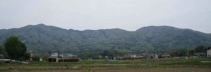
Mt. Ashio is a 627.3 m peak on the boundary between Ishioka and Sakuragawa cities in Ibaraki Prefecture, in the northern part of the Tsukuba range between Mt. Maruyama and Mt. Tsubame. The 8th-century 'Hitachi-no-kuni Fudoki' records the mountain as 'Ashiho-yama', and tradition holds that Emperor Daigo recovered from a foot ailment after praying here in the Heian period — the name 'Ashio' ('foot-tail') and its imperial sanction date from that event. Ashio Shrine, said to heal afflictions of the feet, stands just below the summit and continues to receive offerings of sandals, shoes and even prosthetic limbs from pilgrims. Together with Mt. Kaba and Mt. Tsukuba it forms the 'Three Mountains of Hitachi', and the broad summit ridge is also a well-known launch site for hang-gliders and paragliders. The mountain features in the 'Mountains of Ibaraki' prefectural climbing guide.
Mt. Ashio at a glance
- Weather: The most settled day in the next 7 days is Sun, November 8: clear, gusts up to 5 m/s.
Mt. Ashio weather (hourly, 14 days)
Sunrise today 06:04, sunset 16:43
| Tue, 11/3 | Wed, 11/4 | Thu, 11/5 | Fri, 11/6 | Sat, 11/7 | Sun, 11/8 | Mon, 11/9 | Tue, 11/10 | Wed, 11/11 | Thu, 11/12 | Fri, 11/13 | Sat, 11/14 | Sun, 11/15 | Mon, 11/16 | Tue, 11/17 | |||||||||||||||||||||||||||||||||||||||||||||||||||||||||||||||||||||||
|---|---|---|---|---|---|---|---|---|---|---|---|---|---|---|---|---|---|---|---|---|---|---|---|---|---|---|---|---|---|---|---|---|---|---|---|---|---|---|---|---|---|---|---|---|---|---|---|---|---|---|---|---|---|---|---|---|---|---|---|---|---|---|---|---|---|---|---|---|---|---|---|---|---|---|---|---|---|---|---|---|---|---|---|---|---|
| Japan time | 15 | 17 | 19 | 21 | 23 | 1 | 3 | 5 | 7 | 9 | 11 | 13 | 15 | 18 | 21 | 0 | 3 | 6 | 9 | 12 | 15 | 18 | 21 | 0 | 3 | 6 | 9 | 12 | 15 | 18 | 21 | 0 | 3 | 6 | 9 | 12 | 15 | 18 | 21 | 0 | 3 | 6 | 9 | 12 | 15 | 18 | 21 | 0 | 3 | 6 | 9 | 15 | 21 | 3 | 9 | 15 | 21 | 3 | 9 | 15 | 21 | 3 | 9 | 15 | 21 | 3 | 9 | 15 | 21 | 3 | 9 | 15 | 21 | 3 | 9 | 15 | 21 | 3 | 9 | 15 | 21 | 3 | 9 | 15 | |
  |   |   |   | | | | | |   | | | | |   | | | |   |   | |   |   | | | |   |  | |  | | | | | | | | | | | | | | | | | | | | | | | | | |   | |   | | | |  | | | | | | | | | | | | | | | | | | | | | | | ||
| Temperature | °C | 15° | 11° | 10° | 11° | 10° | 9° | 9° | 9° | 9° | 10° | 12° | 12° | 11° | 11° | 10° | 8° | 9° | 9° | 11° | 13° | 14° | 12° | 10° | 10° | 10° | 9° | 13° | 18° | 19° | 13° | 12° | 10° | 10° | 6° | 11° | 14° | 12° | 7° | 4° | 7° | 6° | 4° | 8° | 12° | 12° | 8° | 7° | 7° | 7° | 6° | 7° | 9° | 7° | 6° | 9° | 8° | 4° | 2° | 9° | 11° | 6° | 3° | 8° | 11° | 7° | 4° | 10° | 10° | 4° | 1° | 6° | 9° | 4° | 4° | 10° | 13° | 11° | 10° | 12° | 18° | 7° | 4° | 6° | 8° |
| Precipitation | mm | 0.1 | 3.2 | 3.0 | 15 | 23 | 3.3 | 4.0 | 0.2 | 0.1 | 0.1 | 0.1 | 0.2 | 3.2 | 8 | ||||||||||||||||||||||||||||||||||||||||||||||||||||||||||||||||||||||
| New snow | cm | ||||||||||||||||||||||||||||||||||||||||||||||||||||||||||||||||||||||||||||||||||||
| Snow depth | cm | 0 | 0 | 0 | 0 | 0 | 0 | 0 | 0 | 0 | 0 | 0 | 0 | 0 | 0 | 0 | 0 | 0 | 0 | 0 | 0 | 0 | 0 | 0 | 0 | 0 | 0 | 0 | 0 | 0 | 0 | 0 | 0 | 0 | 0 | 0 | 0 | 0 | 0 | 0 | 0 | 0 | 0 | 0 | 0 | 0 | 0 | 0 | 0 | 0 | 0 | 0 | 0 | 0 | 0 | 0 | 0 | 0 | 0 | 0 | 0 | 0 | 0 | 0 | 0 | 0 | 0 | 0 | 0 | 0 | 0 | 0 | 0 | 0 | 0 | 0 | 0 | 0 | 0 | 0 | 0 | 0 | 0 | 0 | 0 |
| Wind | m/s | 2 | 2 | 3 | 2 | 2 | 2 | 2 | 2 | 2 | 2 | 3 | 3 | 2 | 2 | 2 | 3 | 4 | 5 | 5 | 2 | 1 | 1 | 1 | 1 | 1 | 1 | 1 | 2 | 2 | 1 | 3 | 3 | 2 | 1 | 2 | 5 | 5 | 1 | 1 | 1 | 2 | 1 | 2 | 0 | 2 | 2 | 2 | 2 | 2 | 2 | 3 | 3 | 3 | 3 | 4 | 4 | 1 | 2 | 4 | 4 | 2 | 0 | 1 | 2 | 0 | 1 | 2 | 5 | 3 | 2 | 1 | 2 | 1 | 1 | 1 | 2 | 2 | 1 | 1 | 4 | 2 | 3 | 2 | 3 |
| Wind gusts | m/s | 6 | 6 | 6 | 7 | 4 | 5 | 6 | 5 | 4 | 5 | 6 | 7 | 6 | 5 | 5 | 7 | 8 | 12 | 13 | 11 | 6 | 2 | 3 | 3 | 3 | 4 | 5 | 5 | 6 | 4 | 8 | 7 | 6 | 4 | 6 | 12 | 14 | 11 | 4 | 4 | 5 | 5 | 5 | 5 | 4 | 6 | 5 | 4 | 5 | 5 | 6 | 7 | 7 | 7 | 8 | 9 | 9 | 4 | 9 | 11 | 10 | 6 | 3 | 6 | 4 | 2 | 6 | 11 | 11 | 7 | 5 | 5 | 5 | 3 | 3 | 8 | 6 | 8 | 5 | 9 | 16 | 9 | 6 | 6 |
| Wind dir. | ↓ | ↓ | ↓ | ↓ | ↓ | ↓ | ↓ | ↓ | ↓ | ↓ | ↓ | ↓ | ↓ | ↓ | ↓ | ↓ | ↓ | ↓ | ↓ | ↓ | ↓ | ↓ | ↓ | ↓ | ↓ | ↓ | ↓ | ↓ | ↓ | ↓ | ↓ | ↓ | ↓ | ↓ | ↓ | ↓ | ↓ | ↓ | ↓ | ↓ | ↓ | ↓ | ↓ | ↓ | ↓ | ↓ | ↓ | ↓ | ↓ | ↓ | ↓ | ↓ | ↓ | ↓ | ↓ | ↓ | ↓ | ↓ | ↓ | ↓ | ↓ | ↓ | ↓ | ↓ | ↓ | ↓ | ↓ | ↓ | ↓ | ↓ | ↓ | ↓ | ↓ | ↓ | ↓ | ↓ | ↓ | ↓ | ↓ | ↓ | ↓ | ↓ | ↓ | ↓ | |
Mt. Ashio facts
- Elevation
- 627 m
- Location
- Ishioka, Ibaraki
36.279712, 140.147744 - Website
- www.city.sakuragawa.lg.jp
- Wikipedia
- ja.wikipedia.org