
Mt. Maruyama
丸山
Ishioka, Ibaraki · Elevation 576 m
Mt. Maruyama is a 576 m peak on the boundary between Sakuragawa and Ishioka cities in Ibaraki Prefecture, set in the northern Tsukuba range between Mt. Kaba (709 m) to the north and Mt. Ashio (628 m) to the south. The summit area carries the turbines of the Wind Power Tsukuba wind farm, in operation since 2005, and the ridge sits on the Kantō Fureai-no-Michi long-distance trail, drawing hikers traversing on from Mt. Kaba and Mt. Ashio. The western slopes are dotted with granite quarries, and Sakuragawa City (former Makabe Town) is nationally known for its Makabe-stone industry. The mountain features in 'Mountains of the Tokyo Area' (2010 edition) and is a representative summit of the northern Tsukuba range.
Mt. Maruyama at a glance
- Weather: The most settled day in the next 7 days is Sun, November 8: clear, gusts up to 5 m/s.
Mt. Maruyama weather (hourly, 14 days)
Sunrise today 06:04, sunset 16:43
| Tue, 11/3 | Wed, 11/4 | Thu, 11/5 | Fri, 11/6 | Sat, 11/7 | Sun, 11/8 | Mon, 11/9 | Tue, 11/10 | Wed, 11/11 | Thu, 11/12 | Fri, 11/13 | Sat, 11/14 | Sun, 11/15 | Mon, 11/16 | Tue, 11/17 | |||||||||||||||||||||||||||||||||||||||||||||||||||||||||||||||||||||||
|---|---|---|---|---|---|---|---|---|---|---|---|---|---|---|---|---|---|---|---|---|---|---|---|---|---|---|---|---|---|---|---|---|---|---|---|---|---|---|---|---|---|---|---|---|---|---|---|---|---|---|---|---|---|---|---|---|---|---|---|---|---|---|---|---|---|---|---|---|---|---|---|---|---|---|---|---|---|---|---|---|---|---|---|---|---|
| Japan time | 15 | 17 | 19 | 21 | 23 | 1 | 3 | 5 | 7 | 9 | 11 | 13 | 15 | 18 | 21 | 0 | 3 | 6 | 9 | 12 | 15 | 18 | 21 | 0 | 3 | 6 | 9 | 12 | 15 | 18 | 21 | 0 | 3 | 6 | 9 | 12 | 15 | 18 | 21 | 0 | 3 | 6 | 9 | 12 | 15 | 18 | 21 | 0 | 3 | 6 | 9 | 15 | 21 | 3 | 9 | 15 | 21 | 3 | 9 | 15 | 21 | 3 | 9 | 15 | 21 | 3 | 9 | 15 | 21 | 3 | 9 | 15 | 21 | 3 | 9 | 15 | 21 | 3 | 9 | 15 | 21 | 3 | 9 | 15 | |
  |   |   |   | | | | | |   | | | | |   | | | |   |   | |   |   | | | |   |  | |  | | | | | | | | | | | | | | | | | | | | | | | | | |   | |   | | | |  | | | | | | | | | | | | | | | | | | | | | | | ||
| Temperature | °C | 15° | 12° | 11° | 11° | 10° | 10° | 10° | 9° | 9° | 10° | 12° | 12° | 12° | 11° | 10° | 9° | 9° | 10° | 11° | 13° | 14° | 12° | 10° | 11° | 11° | 9° | 14° | 19° | 19° | 13° | 12° | 11° | 11° | 7° | 12° | 14° | 13° | 7° | 4° | 7° | 7° | 4° | 9° | 12° | 12° | 8° | 8° | 7° | 7° | 7° | 7° | 9° | 8° | 7° | 9° | 8° | 4° | 2° | 9° | 11° | 6° | 3° | 8° | 11° | 7° | 4° | 11° | 10° | 5° | 1° | 7° | 9° | 4° | 5° | 10° | 14° | 11° | 10° | 12° | 18° | 8° | 4° | 6° | 9° |
| Precipitation | mm | 0.1 | 3.2 | 3.0 | 15 | 23 | 3.3 | 4.0 | 0.2 | 0.1 | 0.1 | 0.1 | 0.2 | 3.2 | 8 | ||||||||||||||||||||||||||||||||||||||||||||||||||||||||||||||||||||||
| New snow | cm | ||||||||||||||||||||||||||||||||||||||||||||||||||||||||||||||||||||||||||||||||||||
| Snow depth | cm | 0 | 0 | 0 | 0 | 0 | 0 | 0 | 0 | 0 | 0 | 0 | 0 | 0 | 0 | 0 | 0 | 0 | 0 | 0 | 0 | 0 | 0 | 0 | 0 | 0 | 0 | 0 | 0 | 0 | 0 | 0 | 0 | 0 | 0 | 0 | 0 | 0 | 0 | 0 | 0 | 0 | 0 | 0 | 0 | 0 | 0 | 0 | 0 | 0 | 0 | 0 | 0 | 0 | 0 | 0 | 0 | 0 | 0 | 0 | 0 | 0 | 0 | 0 | 0 | 0 | 0 | 0 | 0 | 0 | 0 | 0 | 0 | 0 | 0 | 0 | 0 | 0 | 0 | 0 | 0 | 0 | 0 | 0 | 0 |
| Wind | m/s | 2 | 2 | 3 | 2 | 2 | 2 | 2 | 2 | 2 | 2 | 3 | 3 | 2 | 2 | 2 | 3 | 4 | 5 | 5 | 2 | 1 | 1 | 1 | 1 | 1 | 1 | 1 | 2 | 2 | 1 | 3 | 3 | 2 | 1 | 2 | 5 | 5 | 1 | 1 | 1 | 2 | 1 | 2 | 0 | 2 | 2 | 2 | 2 | 2 | 2 | 3 | 3 | 3 | 3 | 4 | 4 | 1 | 2 | 4 | 4 | 2 | 0 | 1 | 2 | 0 | 1 | 2 | 5 | 3 | 2 | 1 | 2 | 1 | 1 | 1 | 2 | 2 | 1 | 1 | 4 | 2 | 3 | 2 | 3 |
| Wind gusts | m/s | 6 | 6 | 6 | 7 | 4 | 5 | 6 | 5 | 4 | 5 | 6 | 7 | 6 | 5 | 5 | 7 | 8 | 12 | 13 | 11 | 6 | 2 | 3 | 3 | 3 | 4 | 5 | 5 | 6 | 4 | 8 | 7 | 6 | 4 | 6 | 12 | 14 | 11 | 4 | 4 | 5 | 5 | 5 | 5 | 4 | 6 | 5 | 4 | 5 | 5 | 6 | 7 | 7 | 7 | 8 | 9 | 9 | 4 | 9 | 11 | 10 | 6 | 3 | 6 | 4 | 2 | 6 | 11 | 11 | 7 | 5 | 5 | 5 | 3 | 3 | 8 | 6 | 8 | 5 | 9 | 16 | 9 | 6 | 6 |
| Wind dir. | ↓ | ↓ | ↓ | ↓ | ↓ | ↓ | ↓ | ↓ | ↓ | ↓ | ↓ | ↓ | ↓ | ↓ | ↓ | ↓ | ↓ | ↓ | ↓ | ↓ | ↓ | ↓ | ↓ | ↓ | ↓ | ↓ | ↓ | ↓ | ↓ | ↓ | ↓ | ↓ | ↓ | ↓ | ↓ | ↓ | ↓ | ↓ | ↓ | ↓ | ↓ | ↓ | ↓ | ↓ | ↓ | ↓ | ↓ | ↓ | ↓ | ↓ | ↓ | ↓ | ↓ | ↓ | ↓ | ↓ | ↓ | ↓ | ↓ | ↓ | ↓ | ↓ | ↓ | ↓ | ↓ | ↓ | ↓ | ↓ | ↓ | ↓ | ↓ | ↓ | ↓ | ↓ | ↓ | ↓ | ↓ | ↓ | ↓ | ↓ | ↓ | ↓ | ↓ | ↓ | |
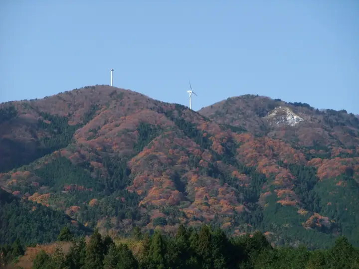
Mt. Maruyama facts
- Elevation
- 576 m
- Location
- Ishioka, Ibaraki
36.291720, 140.151043 - Website
- www.kankou-sakuragawa.jp
- Wikipedia
- ja.wikipedia.org