
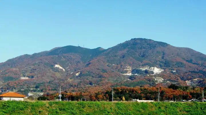
Mt. Tsubakurosan
燕山
Sakuragawa, Ibaraki · Elevation 701 m
Mt. Tsubakurosan, 701 m (north peak), is a twin-peaked summit at the northern end of the Tsukuba Range on the border of Sakuragawa and Ishioka in Ibaraki Prefecture, about 1.4 km north of Mt. Kabasan. Broadcasting relay stations occupy each peak — NHK Mito FM on the south and IBS Lucky FM on the north — and the mountain stands above a region famed nationally for Makabe-stone granite quarrying. Few climbers approach the peak directly; instead it is walked as part of the Kantō Fureai-no-Michi 'Tsukuba Range Traverse 1', the 17.35-km, six-hour ridge connecting Amabiki-kannon, Kabasan, Ashio-yama, Kinoko-yama and Makabe, also shown on the Sakuragawa Tourist Association range map.
Mt. Tsubakurosan at a glance
- Weather: The most settled day in the next 7 days is Fri, November 6: clear, gusts up to 5 m/s.
Mt. Tsubakurosan weather (hourly, 14 days)
Sunrise today 06:04, sunset 16:43
| Tue, 11/3 | Wed, 11/4 | Thu, 11/5 | Fri, 11/6 | Sat, 11/7 | Sun, 11/8 | Mon, 11/9 | Tue, 11/10 | Wed, 11/11 | Thu, 11/12 | Fri, 11/13 | Sat, 11/14 | Sun, 11/15 | Mon, 11/16 | Tue, 11/17 | |||||||||||||||||||||||||||||||||||||||||||||||||||||||||||||||||||||||
|---|---|---|---|---|---|---|---|---|---|---|---|---|---|---|---|---|---|---|---|---|---|---|---|---|---|---|---|---|---|---|---|---|---|---|---|---|---|---|---|---|---|---|---|---|---|---|---|---|---|---|---|---|---|---|---|---|---|---|---|---|---|---|---|---|---|---|---|---|---|---|---|---|---|---|---|---|---|---|---|---|---|---|---|---|---|
| Japan time | 15 | 17 | 19 | 21 | 23 | 1 | 3 | 5 | 7 | 9 | 11 | 13 | 15 | 18 | 21 | 0 | 3 | 6 | 9 | 12 | 15 | 18 | 21 | 0 | 3 | 6 | 9 | 12 | 15 | 18 | 21 | 0 | 3 | 6 | 9 | 12 | 15 | 18 | 21 | 0 | 3 | 6 | 9 | 12 | 15 | 18 | 21 | 0 | 3 | 6 | 9 | 15 | 21 | 3 | 9 | 15 | 21 | 3 | 9 | 15 | 21 | 3 | 9 | 15 | 21 | 3 | 9 | 15 | 21 | 3 | 9 | 15 | 21 | 3 | 9 | 15 | 21 | 3 | 9 | 15 | 21 | 3 | 9 | 15 | |
  |   |   |   | | | | |   | | | | | | |   | | |   |   | |   |   | | | |   |  | | | | |  | | | | | | | | | | | | | | | | | | | | | | | | |   |   | | |  | | | | | | | | | | | | | | | | | | | | | | | ||
| Temperature | °C | 14° | 10° | 9° | 9° | 8° | 8° | 8° | 7° | 8° | 9° | 11° | 11° | 10° | 10° | 9° | 7° | 8° | 8° | 10° | 12° | 12° | 11° | 9° | 9° | 9° | 8° | 12° | 18° | 18° | 12° | 10° | 9° | 9° | 5° | 10° | 12° | 11° | 5° | 3° | 5° | 5° | 3° | 7° | 11° | 11° | 6° | 6° | 5° | 5° | 5° | 6° | 8° | 6° | 5° | 8° | 7° | 3° | 1° | 7° | 10° | 6° | 2° | 7° | 10° | 5° | 3° | 10° | 9° | 3° | 0° | 5° | 8° | 2° | 2° | 8° | 12° | 9° | 8° | 10° | 16° | 7° | 3° | 5° | 8° |
| Precipitation | mm | 4.4 | 3.1 | 15 | 24 | 4.3 | 4.5 | 0.1 | 0.3 | 0.4 | 0.5 | 0.1 | 4.4 | 10 | 0.1 | ||||||||||||||||||||||||||||||||||||||||||||||||||||||||||||||||||||||
| New snow | cm | ||||||||||||||||||||||||||||||||||||||||||||||||||||||||||||||||||||||||||||||||||||
| Snow depth | cm | 0 | 0 | 0 | 0 | 0 | 0 | 0 | 0 | 0 | 0 | 0 | 0 | 0 | 0 | 0 | 0 | 0 | 0 | 0 | 0 | 0 | 0 | 0 | 0 | 0 | 0 | 0 | 0 | 0 | 0 | 0 | 0 | 0 | 0 | 0 | 0 | 0 | 0 | 0 | 0 | 0 | 0 | 0 | 0 | 0 | 0 | 0 | 0 | 0 | 0 | 0 | 0 | 0 | 0 | 0 | 0 | 0 | 0 | 0 | 0 | 0 | 0 | 0 | 0 | 0 | 0 | 0 | 0 | 0 | 0 | 0 | 0 | 0 | 0 | 0 | 0 | 0 | 0 | 0 | 0 | 0 | 0 | 0 | 0 |
| Wind | m/s | 3 | 2 | 3 | 2 | 2 | 2 | 2 | 2 | 2 | 2 | 2 | 2 | 2 | 2 | 2 | 3 | 4 | 5 | 4 | 2 | 1 | 1 | 1 | 1 | 1 | 1 | 1 | 1 | 1 | 2 | 3 | 3 | 3 | 1 | 2 | 5 | 6 | 1 | 1 | 1 | 2 | 2 | 2 | 1 | 3 | 2 | 2 | 2 | 2 | 2 | 3 | 3 | 3 | 3 | 3 | 4 | 1 | 1 | 3 | 5 | 4 | 0 | 1 | 2 | 1 | 1 | 4 | 6 | 4 | 2 | 1 | 2 | 1 | 1 | 1 | 2 | 1 | 1 | 1 | 5 | 5 | 3 | 2 | 2 |
| Wind gusts | m/s | 6 | 6 | 6 | 6 | 5 | 4 | 4 | 4 | 4 | 5 | 6 | 6 | 6 | 5 | 4 | 6 | 8 | 11 | 11 | 9 | 6 | 3 | 3 | 2 | 2 | 3 | 4 | 5 | 5 | 4 | 7 | 7 | 8 | 5 | 6 | 11 | 14 | 12 | 3 | 3 | 5 | 5 | 5 | 6 | 6 | 8 | 5 | 4 | 5 | 5 | 6 | 7 | 7 | 7 | 8 | 9 | 8 | 4 | 7 | 12 | 14 | 9 | 4 | 6 | 5 | 2 | 9 | 12 | 13 | 8 | 4 | 6 | 5 | 2 | 3 | 8 | 6 | 7 | 4 | 12 | 18 | 11 | 6 | 6 |
| Wind dir. | ↓ | ↓ | ↓ | ↓ | ↓ | ↓ | ↓ | ↓ | ↓ | ↓ | ↓ | ↓ | ↓ | ↓ | ↓ | ↓ | ↓ | ↓ | ↓ | ↓ | ↓ | ↓ | ↓ | ↓ | ↓ | ↓ | ↓ | ↓ | ↓ | ↓ | ↓ | ↓ | ↓ | ↓ | ↓ | ↓ | ↓ | ↓ | ↓ | ↓ | ↓ | ↓ | ↓ | ↓ | ↓ | ↓ | ↓ | ↓ | ↓ | ↓ | ↓ | ↓ | ↓ | ↓ | ↓ | ↓ | ↓ | ↓ | ↓ | ↓ | ↓ | ↓ | ↓ | ↓ | ↓ | ↓ | ↓ | ↓ | ↓ | ↓ | ↓ | ↓ | ↓ | ↓ | ↓ | ↓ | ↓ | ↓ | ↓ | ↓ | ↓ | ↓ | ↓ | ↓ | |
Mt. Tsubakurosan facts
- Elevation
- 701 m
- Location
- Sakuragawa, Ibaraki
36.308040, 140.142186 - Website
- www.pref.ibaraki.jp
- Trail Map
- www.pref.ibaraki.jp (PDF)
- Access Information
- www.kankou-sakuragawa.jp
- Wikipedia
- ja.wikipedia.org