
Mt. Kabasan
加波山
Sakuragawa, Ibaraki · Elevation 709 m
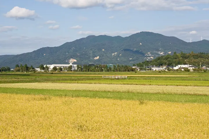
Mt. Kabasan is a 709-meter peak on the border of Sakuragawa City and Ishioka City in Ibaraki Prefecture, one of the northern peaks of the Tsukuba range. According to tradition the summit shrine, Kabasan Jinja Hongu, was founded by Yamato Takeru, and the mountain has long been worshipped as a sacred peak: shugendo ascetics still perform zenjō rites here, and the mountain is also famed as the site of the 1884 "Kabasan Incident" of the Meiji-era freedom and people's-rights movement. Strange boulders and rows of carved stones scatter the slopes, lending the trail a distinctive spiritual atmosphere, and the peak is featured in the Kanto Hyakumeizan and Nihon Hyaku Reizan lists.
Mt. Kabasan at a glance
- Weather: The most settled day in the next 7 days is Sun, November 8: clear, gusts up to 5 m/s.
- Route: The shortest is Mount Kaba Loop from the Third Station Trailhead: about 2 h 41 min, 4.3 km, about 530 m of climbing.
Mt. Kabasan weather (hourly, 14 days)
Sunrise today 06:04, sunset 16:43
| Tue, 11/3 | Wed, 11/4 | Thu, 11/5 | Fri, 11/6 | Sat, 11/7 | Sun, 11/8 | Mon, 11/9 | Tue, 11/10 | Wed, 11/11 | Thu, 11/12 | Fri, 11/13 | Sat, 11/14 | Sun, 11/15 | Mon, 11/16 | Tue, 11/17 | |||||||||||||||||||||||||||||||||||||||||||||||||||||||||||||||||||||||
|---|---|---|---|---|---|---|---|---|---|---|---|---|---|---|---|---|---|---|---|---|---|---|---|---|---|---|---|---|---|---|---|---|---|---|---|---|---|---|---|---|---|---|---|---|---|---|---|---|---|---|---|---|---|---|---|---|---|---|---|---|---|---|---|---|---|---|---|---|---|---|---|---|---|---|---|---|---|---|---|---|---|---|---|---|---|
| Japan time | 15 | 17 | 19 | 21 | 23 | 1 | 3 | 5 | 7 | 9 | 11 | 13 | 15 | 18 | 21 | 0 | 3 | 6 | 9 | 12 | 15 | 18 | 21 | 0 | 3 | 6 | 9 | 12 | 15 | 18 | 21 | 0 | 3 | 6 | 9 | 12 | 15 | 18 | 21 | 0 | 3 | 6 | 9 | 12 | 15 | 18 | 21 | 0 | 3 | 6 | 9 | 15 | 21 | 3 | 9 | 15 | 21 | 3 | 9 | 15 | 21 | 3 | 9 | 15 | 21 | 3 | 9 | 15 | 21 | 3 | 9 | 15 | 21 | 3 | 9 | 15 | 21 | 3 | 9 | 15 | 21 | 3 | 9 | 15 | |
  |   |   |   | | | | | |   | | | | |   | | | |   |   | |   |   | | | |   |  | |  | | | | | | | | | | | | | | | | | | | | | | | | | |   | |   | | | |  | | | | | | | | | | | | | | | | | | | | | | | ||
| Temperature | °C | 15° | 11° | 10° | 10° | 9° | 9° | 9° | 8° | 8° | 9° | 11° | 11° | 11° | 10° | 9° | 8° | 8° | 9° | 10° | 12° | 13° | 11° | 9° | 10° | 10° | 9° | 13° | 18° | 18° | 13° | 11° | 10° | 10° | 6° | 11° | 13° | 12° | 6° | 3° | 6° | 6° | 3° | 8° | 11° | 11° | 7° | 7° | 6° | 6° | 6° | 6° | 9° | 7° | 6° | 8° | 7° | 3° | 1° | 8° | 11° | 5° | 2° | 7° | 10° | 7° | 3° | 10° | 10° | 4° | 0° | 6° | 9° | 3° | 4° | 9° | 13° | 10° | 9° | 11° | 17° | 7° | 3° | 5° | 8° |
| Precipitation | mm | 0.1 | 3.2 | 3.0 | 15 | 23 | 3.3 | 4.0 | 0.2 | 0.1 | 0.1 | 0.1 | 0.2 | 3.2 | 8 | ||||||||||||||||||||||||||||||||||||||||||||||||||||||||||||||||||||||
| New snow | cm | ||||||||||||||||||||||||||||||||||||||||||||||||||||||||||||||||||||||||||||||||||||
| Snow depth | cm | 0 | 0 | 0 | 0 | 0 | 0 | 0 | 0 | 0 | 0 | 0 | 0 | 0 | 0 | 0 | 0 | 0 | 0 | 0 | 0 | 0 | 0 | 0 | 0 | 0 | 0 | 0 | 0 | 0 | 0 | 0 | 0 | 0 | 0 | 0 | 0 | 0 | 0 | 0 | 0 | 0 | 0 | 0 | 0 | 0 | 0 | 0 | 0 | 0 | 0 | 0 | 0 | 0 | 0 | 0 | 0 | 0 | 0 | 0 | 0 | 0 | 0 | 0 | 0 | 0 | 0 | 0 | 0 | 0 | 0 | 0 | 0 | 0 | 0 | 0 | 0 | 0 | 0 | 0 | 0 | 0 | 0 | 0 | 0 |
| Wind | m/s | 2 | 2 | 3 | 2 | 2 | 2 | 2 | 2 | 2 | 2 | 3 | 3 | 2 | 2 | 2 | 3 | 4 | 5 | 5 | 2 | 1 | 1 | 1 | 1 | 1 | 1 | 1 | 2 | 2 | 1 | 3 | 3 | 2 | 1 | 2 | 5 | 5 | 1 | 1 | 1 | 2 | 1 | 2 | 0 | 2 | 2 | 2 | 2 | 2 | 2 | 3 | 3 | 3 | 3 | 4 | 4 | 1 | 2 | 4 | 4 | 2 | 0 | 1 | 2 | 0 | 1 | 2 | 5 | 3 | 2 | 1 | 2 | 1 | 1 | 1 | 2 | 2 | 1 | 1 | 4 | 2 | 3 | 2 | 3 |
| Wind gusts | m/s | 6 | 6 | 6 | 7 | 4 | 5 | 6 | 5 | 4 | 5 | 6 | 7 | 6 | 5 | 5 | 7 | 8 | 12 | 13 | 11 | 6 | 2 | 3 | 3 | 3 | 4 | 5 | 5 | 6 | 4 | 8 | 7 | 6 | 4 | 6 | 12 | 14 | 11 | 4 | 4 | 5 | 5 | 5 | 5 | 4 | 6 | 5 | 4 | 5 | 5 | 6 | 7 | 7 | 7 | 8 | 9 | 9 | 4 | 9 | 11 | 10 | 6 | 3 | 6 | 4 | 2 | 6 | 11 | 11 | 7 | 5 | 5 | 5 | 3 | 3 | 8 | 6 | 8 | 5 | 9 | 16 | 9 | 6 | 6 |
| Wind dir. | ↓ | ↓ | ↓ | ↓ | ↓ | ↓ | ↓ | ↓ | ↓ | ↓ | ↓ | ↓ | ↓ | ↓ | ↓ | ↓ | ↓ | ↓ | ↓ | ↓ | ↓ | ↓ | ↓ | ↓ | ↓ | ↓ | ↓ | ↓ | ↓ | ↓ | ↓ | ↓ | ↓ | ↓ | ↓ | ↓ | ↓ | ↓ | ↓ | ↓ | ↓ | ↓ | ↓ | ↓ | ↓ | ↓ | ↓ | ↓ | ↓ | ↓ | ↓ | ↓ | ↓ | ↓ | ↓ | ↓ | ↓ | ↓ | ↓ | ↓ | ↓ | ↓ | ↓ | ↓ | ↓ | ↓ | ↓ | ↓ | ↓ | ↓ | ↓ | ↓ | ↓ | ↓ | ↓ | ↓ | ↓ | ↓ | ↓ | ↓ | ↓ | ↓ | ↓ | ↓ | |
Mt. Kabasan hiking routes
Hiking times are estimates calculated from the terrain.
Lists that include Mt. Kabasan
100 Low Mountains of Japan · Kanto 100 Famous Mountains · Elevations of 1003 Mountains of Japan · 1000 Mountains of Japan
Mt. Kabasan facts
- Elevation
- 709 m
- Location
- Sakuragawa, Ibaraki
36.298823, 140.143678 - Website
- www.kankou-sakuragawa.jp
- Trail Map
- www.kankou-sakuragawa.jp (PDF)
- Access Information
- www.kankou-sakuragawa.jp
- Wikipedia
- ja.wikipedia.org