
Mt. Ashio
足尾山
อิชิโอกะ, อิบารากิ · ความสูง 627 ม.
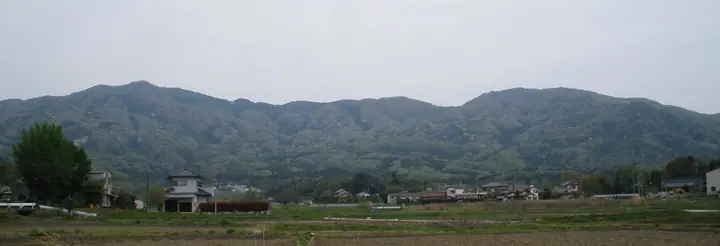
Mt. Ashio is a 627.3 m peak on the boundary between Ishioka and Sakuragawa cities in Ibaraki Prefecture, in the northern part of the Tsukuba range between Mt. Maruyama and Mt. Tsubame. The 8th-century 'Hitachi-no-kuni Fudoki' records the mountain as 'Ashiho-yama', and tradition holds that Emperor Daigo recovered from a foot ailment after praying here in the Heian period — the name 'Ashio' ('foot-tail') and its imperial sanction date from that event. Ashio Shrine, said to heal afflictions of the feet, stands just below the summit and continues to receive offerings of sandals, shoes and even prosthetic limbs from pilgrims. Together with Mt. Kaba and Mt. Tsukuba it forms the 'Three Mountains of Hitachi', and the broad summit ridge is also a well-known launch site for hang-gliders and paragliders. The mountain features in the 'Mountains of Ibaraki' prefectural climbing guide.
สรุป Mt. Ashio
- อากาศ: วันที่อากาศคงที่ที่สุดใน 7 วันข้างหน้าคือ อาทิตย์ 8 พฤศจิกายน: ท้องฟ้าแจ่มใส ลมกระโชกสูงสุด 6 ม./วินาที
อากาศ Mt. Ashio (รายชั่วโมง 2 สัปดาห์)
วันนี้พระอาทิตย์ขึ้น 06:04 ตก 16:43
| อังคาร 3/11 | พุธ 4/11 | พฤหัส 5/11 | ศุกร์ 6/11 | เสาร์ 7/11 | อาทิตย์ 8/11 | จันทร์ 9/11 | อังคาร 10/11 | พุธ 11/11 | พฤหัส 12/11 | ศุกร์ 13/11 | เสาร์ 14/11 | อาทิตย์ 15/11 | จันทร์ 16/11 | อังคาร 17/11 | |||||||||||||||||||||||||||||||||||||||||||||||||||||||||||||||||||||||
|---|---|---|---|---|---|---|---|---|---|---|---|---|---|---|---|---|---|---|---|---|---|---|---|---|---|---|---|---|---|---|---|---|---|---|---|---|---|---|---|---|---|---|---|---|---|---|---|---|---|---|---|---|---|---|---|---|---|---|---|---|---|---|---|---|---|---|---|---|---|---|---|---|---|---|---|---|---|---|---|---|---|---|---|---|---|
| เวลาญี่ปุ่น | 21 | 23 | 1 | 3 | 5 | 7 | 9 | 11 | 13 | 15 | 17 | 19 | 21 | 0 | 3 | 6 | 9 | 12 | 15 | 18 | 21 | 0 | 3 | 6 | 9 | 12 | 15 | 18 | 21 | 0 | 3 | 6 | 9 | 12 | 15 | 18 | 21 | 0 | 3 | 6 | 9 | 12 | 15 | 18 | 21 | 0 | 3 | 6 | 9 | 12 | 15 | 21 | 3 | 9 | 15 | 21 | 3 | 9 | 15 | 21 | 3 | 9 | 15 | 21 | 3 | 9 | 15 | 21 | 3 | 9 | 15 | 21 | 3 | 9 | 15 | 21 | 3 | 9 | 15 | 21 | 3 | 9 | 15 | 21 | |
  |   | | | |   |   | | | | | |   | | | |   |   | | |  | | | |  | | | |   | | | | | | | | | | | | | |   | | | | | | | | | | | |   |   |   | | | |  | | | | | | | | | | | | | | | |   | | | | | | | | ||
| อุณหภูมิ | °C | 10° | 9° | 9° | 9° | 9° | 9° | 11° | 12° | 11° | 11° | 11° | 10° | 9° | 8° | 9° | 10° | 10° | 13° | 14° | 11° | 10° | 10° | 10° | 10° | 15° | 20° | 19° | 14° | 12° | 11° | 9° | 7° | 11° | 14° | 12° | 7° | 4° | 2° | 4° | 3° | 8° | 11° | 11° | 7° | 5° | 5° | 5° | 4° | 5° | 6° | 8° | 7° | 6° | 9° | 8° | 4° | 2° | 9° | 11° | 6° | 3° | 8° | 11° | 7° | 4° | 10° | 10° | 4° | 1° | 6° | 9° | 4° | 4° | 10° | 13° | 11° | 10° | 12° | 18° | 7° | 4° | 6° | 8° | 4° |
| ฝนและหิมะ | mm | 1.2 | 4.7 | 8 | 8 | 13 | 0.4 | 1.6 | 5 | 3.3 | 1.4 | 0.1 | 0.1 | 0.1 | 0.1 | 0.2 | 3.2 | 8 | |||||||||||||||||||||||||||||||||||||||||||||||||||||||||||||||||||
| หิมะตก | cm | ||||||||||||||||||||||||||||||||||||||||||||||||||||||||||||||||||||||||||||||||||||
| หิมะสะสม | cm | 0 | 0 | 0 | 0 | 0 | 0 | 0 | 0 | 0 | 0 | 0 | 0 | 0 | 0 | 0 | 0 | 0 | 0 | 0 | 0 | 0 | 0 | 0 | 0 | 0 | 0 | 0 | 0 | 0 | 0 | 0 | 0 | 0 | 0 | 0 | 0 | 0 | 0 | 0 | 0 | 0 | 0 | 0 | 0 | 0 | 0 | 0 | 0 | 0 | 0 | 0 | 0 | 0 | 0 | 0 | 0 | 0 | 0 | 0 | 0 | 0 | 0 | 0 | 0 | 0 | 0 | 0 | 0 | 0 | 0 | 0 | 0 | 0 | 0 | 0 | 0 | 0 | 0 | 0 | 0 | 0 | 0 | 0 | 0 |
| ลม | m/s | 2 | 2 | 2 | 2 | 2 | 2 | 2 | 3 | 3 | 2 | 2 | 2 | 3 | 4 | 4 | 5 | 6 | 3 | 1 | 1 | 1 | 1 | 0 | 0 | 1 | 1 | 3 | 0 | 3 | 4 | 3 | 1 | 1 | 5 | 5 | 1 | 1 | 1 | 2 | 1 | 1 | 1 | 3 | 2 | 2 | 2 | 3 | 3 | 3 | 3 | 3 | 3 | 3 | 4 | 4 | 1 | 2 | 4 | 4 | 2 | 0 | 1 | 2 | 0 | 1 | 2 | 5 | 3 | 2 | 1 | 2 | 1 | 1 | 1 | 2 | 2 | 1 | 1 | 4 | 2 | 3 | 2 | 3 | 2 |
| ลมกระโชก | m/s | 6 | 5 | 5 | 5 | 5 | 4 | 6 | 7 | 7 | 7 | 5 | 6 | 6 | 9 | 9 | 11 | 13 | 13 | 7 | 3 | 3 | 3 | 3 | 3 | 4 | 5 | 6 | 7 | 7 | 8 | 8 | 8 | 4 | 12 | 12 | 11 | 4 | 4 | 4 | 5 | 5 | 5 | 6 | 7 | 6 | 5 | 6 | 8 | 7 | 7 | 7 | 7 | 7 | 8 | 9 | 9 | 4 | 9 | 11 | 10 | 6 | 3 | 6 | 4 | 2 | 6 | 11 | 11 | 7 | 5 | 5 | 5 | 3 | 3 | 8 | 6 | 8 | 5 | 9 | 16 | 9 | 6 | 6 | 6 |
| ทิศทางลม | ↓ | ↓ | ↓ | ↓ | ↓ | ↓ | ↓ | ↓ | ↓ | ↓ | ↓ | ↓ | ↓ | ↓ | ↓ | ↓ | ↓ | ↓ | ↓ | ↓ | ↓ | ↓ | ↓ | ↓ | ↓ | ↓ | ↓ | ↓ | ↓ | ↓ | ↓ | ↓ | ↓ | ↓ | ↓ | ↓ | ↓ | ↓ | ↓ | ↓ | ↓ | ↓ | ↓ | ↓ | ↓ | ↓ | ↓ | ↓ | ↓ | ↓ | ↓ | ↓ | ↓ | ↓ | ↓ | ↓ | ↓ | ↓ | ↓ | ↓ | ↓ | ↓ | ↓ | ↓ | ↓ | ↓ | ↓ | ↓ | ↓ | ↓ | ↓ | ↓ | ↓ | ↓ | ↓ | ↓ | ↓ | ↓ | ↓ | ↓ | ↓ | ↓ | ↓ | ↓ | |
ข้อมูลพื้นฐาน Mt. Ashio
- ความสูง
- 627 ม.
- ที่ตั้ง
- อิชิโอกะ, อิบารากิ
36.279712, 140.147744 - เว็บไซต์
- www.city.sakuragawa.lg.jp
- วิกิพีเดีย
- ja.wikipedia.org