
Mount Yufu
由布岳
Yufu, Oita · Elevation 1,583 m
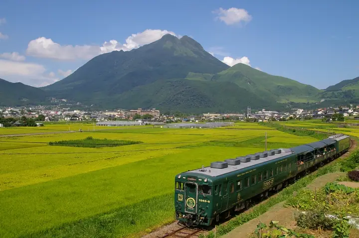
Mount Yufu is a 1,583 m active volcano in Yufu City, Oita Prefecture, within Aso-Kuju National Park. Its graceful Fuji-shaped silhouette has earned it the nickname Bungo-Fuji, and its historical name was 木綿山. The summit has East and West peaks and a first-order triangulation marker. The standard ascent starts at the Main trailhead, with free parking on the boundary of Beppu and Yufu, and climbs via Aino-koshi. Alternative loop routes start at the East and West trailheads. Summit views encompass the Yufuin Basin, Beppu Bay, the Kuju range and Mount Aso, overlooking the Yufuin and Beppu hot-spring towns.
Mount Yufu at a glance
- Weather: The most settled day in the next 7 days is Sun, November 8: cloudy, gusts up to 6 m/s. Fri, Nov 6, Sat, Nov 7: strong wind (gusts up to 17 m/s).
- Route: The shortest is Mount Yufu East Peak Circuit from the Main Trailhead via Hinatayama Junction and Aigoe Pass: about 4 h 47 min, 6.9 km, about 860 m of climbing.
Mount Yufu weather (hourly, 14 days)
Sunrise today 06:34, sunset 17:22
| Tue, 11/3 | Wed, 11/4 | Thu, 11/5 | Fri, 11/6 | Sat, 11/7 | Sun, 11/8 | Mon, 11/9 | Tue, 11/10 | Wed, 11/11 | Thu, 11/12 | Fri, 11/13 | Sat, 11/14 | Sun, 11/15 | Mon, 11/16 | Tue, 11/17 | |||||||||||||||||||||||||||||||||||||||||||||||||||||||||||||||||||||||
|---|---|---|---|---|---|---|---|---|---|---|---|---|---|---|---|---|---|---|---|---|---|---|---|---|---|---|---|---|---|---|---|---|---|---|---|---|---|---|---|---|---|---|---|---|---|---|---|---|---|---|---|---|---|---|---|---|---|---|---|---|---|---|---|---|---|---|---|---|---|---|---|---|---|---|---|---|---|---|---|---|---|---|---|---|---|
| Japan time | 15 | 17 | 19 | 21 | 23 | 1 | 3 | 5 | 7 | 9 | 11 | 13 | 15 | 18 | 21 | 0 | 3 | 6 | 9 | 12 | 15 | 18 | 21 | 0 | 3 | 6 | 9 | 12 | 15 | 18 | 21 | 0 | 3 | 6 | 9 | 12 | 15 | 18 | 21 | 0 | 3 | 6 | 9 | 12 | 15 | 18 | 21 | 0 | 3 | 6 | 9 | 15 | 21 | 3 | 9 | 15 | 21 | 3 | 9 | 15 | 21 | 3 | 9 | 15 | 21 | 3 | 9 | 15 | 21 | 3 | 9 | 15 | 21 | 3 | 9 | 15 | 21 | 3 | 9 | 15 | 21 | 3 | 9 | 15 | |
  | |   |   | | |   | |   | | | |   | | | |   | |  |   | | |   | | |   | |   | |  | | | | | | | | | | | | | | | | | | | |   | | | | | | | | | | | |  | | | | | | | | | | | | | | | | | | | | | | | ||
| Temperature | °C | 8° | 6° | 4° | 4° | 3° | 3° | 4° | 4° | 4° | 6° | 8° | 10° | 10° | 7° | 7° | 6° | 7° | 6° | 9° | 12° | 11° | 10° | 10° | 8° | 8° | 5° | 7° | 9° | 8° | 2° | 1° | 0° | -2° | -2° | 1° | 4° | 4° | -1° | -2° | -2° | -2° | -1° | 4° | 6° | 6° | 3° | 3° | 3° | 3° | 3° | 5° | 6° | 1° | 0° | 3° | 5° | 1° | 0° | 0° | 3° | -1° | -2° | 3° | 6° | -1° | 0° | 4° | 6° | 2° | 1° | 4° | 9° | 4° | 6° | 9° | 9° | 7° | 8° | 6° | 9° | 3° | 2° | 2° | 6° |
| Precipitation | mm | 1.7 | 0.2 | 1.8 | 3.3 | 1.5 | 0.3 | 0.2 | 0.3 | 0.2 | 0.3 | 0.4 | 0.4 | 1.0 | 5 | 1.7 | 0.8 | 0.9 | 0.8 | 0.7 | |||||||||||||||||||||||||||||||||||||||||||||||||||||||||||||||||
| New snow | cm | ||||||||||||||||||||||||||||||||||||||||||||||||||||||||||||||||||||||||||||||||||||
| Snow depth | cm | 0 | 0 | 0 | 0 | 0 | 0 | 0 | 0 | 0 | 0 | 0 | 0 | 0 | 0 | 0 | 0 | 0 | 0 | 0 | 0 | 0 | 0 | 0 | 0 | 0 | 0 | 0 | 0 | 0 | 0 | 0 | 0 | 0 | 0 | 0 | 0 | 0 | 0 | 0 | 0 | 0 | 0 | 0 | 0 | 0 | 0 | 0 | 0 | 0 | 0 | 0 | 0 | 0 | 0 | 0 | 0 | 0 | 0 | 0 | 0 | 0 | 0 | 0 | 0 | 0 | 0 | 0 | 0 | 0 | 0 | 0 | 0 | 0 | 0 | 0 | 0 | 0 | 0 | 0 | 0 | 0 | 0 | 0 | 0 |
| Wind | m/s | 3 | 2 | 2 | 1 | 1 | 1 | 1 | 1 | 1 | 2 | 3 | 2 | 2 | 1 | 2 | 1 | 0 | 1 | 2 | 1 | 2 | 3 | 4 | 5 | 5 | 5 | 5 | 6 | 6 | 6 | 6 | 6 | 6 | 6 | 5 | 4 | 4 | 2 | 1 | 1 | 0 | 0 | 2 | 2 | 2 | 1 | 0 | 0 | 1 | 2 | 3 | 4 | 2 | 2 | 4 | 5 | 4 | 4 | 4 | 4 | 1 | 1 | 1 | 3 | 2 | 2 | 2 | 2 | 0 | 1 | 2 | 1 | 1 | 2 | 4 | 1 | 1 | 4 | 4 | 5 | 2 | 1 | 1 | 3 |
| Wind gusts | m/s | 10 | 9 | 7 | 7 | 5 | 3 | 3 | 3 | 3 | 6 | 8 | 8 | 7 | 6 | 6 | 6 | 3 | 4 | 6 | 6 | 8 | 10 | 10 | 15 | 14 | 15 | 15 | 17 | 17 | 15 | 16 | 16 | 16 | 16 | 15 | 14 | 12 | 11 | 6 | 4 | 3 | 3 | 5 | 6 | 6 | 6 | 2 | 3 | 4 | 5 | 9 | 10 | 10 | 6 | 11 | 14 | 14 | 12 | 12 | 11 | 10 | 4 | 4 | 8 | 8 | 7 | 7 | 10 | 6 | 5 | 5 | 7 | 6 | 8 | 12 | 13 | 7 | 10 | 12 | 13 | 12 | 6 | 4 | 8 |
| Wind dir. | ↓ | ↓ | ↓ | ↓ | ↓ | ↓ | ↓ | ↓ | ↓ | ↓ | ↓ | ↓ | ↓ | ↓ | ↓ | ↓ | ↓ | ↓ | ↓ | ↓ | ↓ | ↓ | ↓ | ↓ | ↓ | ↓ | ↓ | ↓ | ↓ | ↓ | ↓ | ↓ | ↓ | ↓ | ↓ | ↓ | ↓ | ↓ | ↓ | ↓ | ↓ | ↓ | ↓ | ↓ | ↓ | ↓ | ↓ | ↓ | ↓ | ↓ | ↓ | ↓ | ↓ | ↓ | ↓ | ↓ | ↓ | ↓ | ↓ | ↓ | ↓ | ↓ | ↓ | ↓ | ↓ | ↓ | ↓ | ↓ | ↓ | ↓ | ↓ | ↓ | ↓ | ↓ | ↓ | ↓ | ↓ | ↓ | ↓ | ↓ | ↓ | ↓ | ↓ | ||
Mount Yufu hiking routes
- Mount Yufu East Peak Circuit from the Main Trailhead via Hinatayama Junction and Aigoe Pass 6.9 km · Ascent 862 m Yufutozanguchi (Bus stop), 由布岳登山口前 (parking)
- Mount Yufu Crater Rim Circuit from the Main Trailhead 7.7 km · Ascent 929 m Yufutozanguchi (Bus stop), 由布岳登山口前 (parking)
Hiking times are estimates calculated from the terrain.
Huts, campsites and lodging near Mount Yufu
Lodging
- Country Roads Hostel
- 山荘 無量塔
- 清孔苑
- kaede no shoja
- Toyonokuni Lodge
Lists that include Mount Yufu
Japan 200 Famous Mountains · Japan's 300 Famous Mountains · 100 Famous Mountains with First-order Triangulation Points · New Japan 100 Famous Mountains · 100 Famous Hot Spring Mountains · 100 Fujis of Japan · Kyushu 100 Famous Mountains · Oita 100 Mountains · Elevations of 1003 Mountains of Japan · 1000 Mountains of Japan
Mount Yufu facts
- Also known as
- 豊後富士 · 由布岳西峰・豊後富士・木綿山
- Elevation
- 1,583 m
- Location
- Yufu, Oita
33.282288, 131.390235 - National Park
- 阿蘇くじゅう国立公園
- Volcano
- Active volcano (由布岳)
- Website
- www.city.yufu.oita.jp
- Trail Map
- www.city.yufu.oita.jp (PDF)
- Access Information
- www.visit-oita.jp
- Wikipedia
- ja.wikipedia.org