
Mount Tsurumi
鶴見岳
Beppu, Oita · Elevation 1,375 m
Mount Tsurumi (1,375 m) is an active volcano rising above Beppu City, Oita, at the eastern edge of Aso-Kuju National Park. Looking down on Beppu’s hot-spring resorts, the peak changes with the seasons: Miyamakirishima azaleas in spring, cool air and night views in summer, autumn foliage and winter rime ice. The Beppu Ropeway reaches just below the summit, and each spring the Beppu Tsurumidake Ikki Climb takes participants from sea level on Beppu Bay to the summit.
Mount Tsurumi at a glance
- Weather: The most settled day in the next 7 days is Sun, November 8: clear, gusts up to 6 m/s.
- Route: The shortest is Beppu Short Walk from the Ropeway Top to the Rime and Azalea Summit of Mount Tsurumi above Beppu Bay: about 25 min, 888 m, about 70 m of climbing.
Mount Tsurumi weather (hourly, 14 days)
Sunrise today 06:34, sunset 17:22
| Tue, 11/3 | Wed, 11/4 | Thu, 11/5 | Fri, 11/6 | Sat, 11/7 | Sun, 11/8 | Mon, 11/9 | Tue, 11/10 | Wed, 11/11 | Thu, 11/12 | Fri, 11/13 | Sat, 11/14 | Sun, 11/15 | Mon, 11/16 | Tue, 11/17 | |||||||||||||||||||||||||||||||||||||||||||||||||||||||||||||||||||||||
|---|---|---|---|---|---|---|---|---|---|---|---|---|---|---|---|---|---|---|---|---|---|---|---|---|---|---|---|---|---|---|---|---|---|---|---|---|---|---|---|---|---|---|---|---|---|---|---|---|---|---|---|---|---|---|---|---|---|---|---|---|---|---|---|---|---|---|---|---|---|---|---|---|---|---|---|---|---|---|---|---|---|---|---|---|---|
| Japan time | 15 | 17 | 19 | 21 | 23 | 1 | 3 | 5 | 7 | 9 | 11 | 13 | 15 | 18 | 21 | 0 | 3 | 6 | 9 | 12 | 15 | 18 | 21 | 0 | 3 | 6 | 9 | 12 | 15 | 18 | 21 | 0 | 3 | 6 | 9 | 12 | 15 | 18 | 21 | 0 | 3 | 6 | 9 | 12 | 15 | 18 | 21 | 0 | 3 | 6 | 9 | 15 | 21 | 3 | 9 | 15 | 21 | 3 | 9 | 15 | 21 | 3 | 9 | 15 | 21 | 3 | 9 | 15 | 21 | 3 | 9 | 15 | 21 | 3 | 9 | 15 | 21 | 3 | 9 | 15 | 21 | 3 | 9 | 15 | |
  |   |   |   | | |   | |   | |   | | | | |   | | |  |   | | |   | | |  | | | | | | | | | | | | | | | | | | | | | | | | | | | | | | |   | | | | |  | | | | | | | | | | | | | | |   | | |   | | | | | ||
| Temperature | °C | 10° | 8° | 6° | 6° | 5° | 5° | 6° | 5° | 5° | 8° | 10° | 11° | 11° | 8° | 8° | 8° | 9° | 7° | 10° | 12° | 12° | 11° | 11° | 10° | 9° | 7° | 9° | 12° | 10° | 5° | 4° | 2° | 1° | 0° | 3° | 6° | 6° | 2° | 0° | 0° | 0° | 0° | 5° | 7° | 7° | 5° | 5° | 5° | 5° | 5° | 7° | 9° | 3° | 2° | 6° | 8° | 4° | 2° | 3° | 5° | 0° | -1° | 5° | 8° | 0° | 2° | 7° | 8° | 4° | 3° | 6° | 10° | 5° | 6° | 9° | 10° | 7° | 9° | 9° | 11° | 5° | 4° | 5° | 8° |
| Precipitation | mm | 0.2 | 0.2 | 0.2 | 1.3 | 0.3 | 1.1 | 2.1 | 0.9 | 0.2 | 0.1 | 0.1 | 0.4 | 4.6 | 1.7 | 0.5 | 0.4 | 0.3 | 0.6 | ||||||||||||||||||||||||||||||||||||||||||||||||||||||||||||||||||
| New snow | cm | ||||||||||||||||||||||||||||||||||||||||||||||||||||||||||||||||||||||||||||||||||||
| Snow depth | cm | 0 | 0 | 0 | 0 | 0 | 0 | 0 | 0 | 0 | 0 | 0 | 0 | 0 | 0 | 0 | 0 | 0 | 0 | 0 | 0 | 0 | 0 | 0 | 0 | 0 | 0 | 0 | 0 | 0 | 0 | 0 | 0 | 0 | 0 | 0 | 0 | 0 | 0 | 0 | 0 | 0 | 0 | 0 | 0 | 0 | 0 | 0 | 0 | 0 | 0 | 0 | 0 | 0 | 0 | 0 | 0 | 0 | 0 | 0 | 0 | 0 | 0 | 0 | 0 | 0 | 0 | 0 | 0 | 0 | 0 | 0 | 0 | 0 | 0 | 0 | 0 | 0 | 0 | 0 | 0 | 0 | 0 | 0 | 0 |
| Wind | m/s | 3 | 2 | 2 | 2 | 1 | 1 | 1 | 1 | 1 | 1 | 2 | 2 | 1 | 0 | 1 | 1 | 1 | 1 | 1 | 2 | 1 | 1 | 1 | 4 | 4 | 4 | 5 | 6 | 5 | 5 | 5 | 5 | 5 | 5 | 5 | 4 | 4 | 2 | 2 | 1 | 1 | 1 | 1 | 2 | 2 | 0 | 0 | 0 | 1 | 2 | 3 | 4 | 2 | 2 | 4 | 5 | 4 | 4 | 4 | 4 | 2 | 1 | 1 | 2 | 2 | 2 | 2 | 2 | 1 | 0 | 0 | 2 | 1 | 1 | 2 | 1 | 1 | 3 | 4 | 5 | 2 | 2 | 1 | 3 |
| Wind gusts | m/s | 10 | 9 | 7 | 7 | 5 | 4 | 4 | 3 | 3 | 4 | 7 | 7 | 6 | 5 | 3 | 4 | 3 | 3 | 5 | 6 | 7 | 5 | 6 | 12 | 12 | 12 | 13 | 15 | 15 | 14 | 15 | 16 | 15 | 15 | 14 | 14 | 12 | 11 | 6 | 5 | 3 | 3 | 4 | 6 | 6 | 5 | 2 | 3 | 4 | 6 | 9 | 10 | 10 | 7 | 11 | 13 | 13 | 11 | 11 | 11 | 11 | 5 | 4 | 6 | 7 | 7 | 6 | 9 | 6 | 5 | 3 | 7 | 6 | 7 | 8 | 11 | 6 | 8 | 12 | 14 | 12 | 6 | 5 | 9 |
| Wind dir. | ↓ | ↓ | ↓ | ↓ | ↓ | ↓ | ↓ | ↓ | ↓ | ↓ | ↓ | ↓ | ↓ | ↓ | ↓ | ↓ | ↓ | ↓ | ↓ | ↓ | ↓ | ↓ | ↓ | ↓ | ↓ | ↓ | ↓ | ↓ | ↓ | ↓ | ↓ | ↓ | ↓ | ↓ | ↓ | ↓ | ↓ | ↓ | ↓ | ↓ | ↓ | ↓ | ↓ | ↓ | ↓ | ↓ | ↓ | ↓ | ↓ | ↓ | ↓ | ↓ | ↓ | ↓ | ↓ | ↓ | ↓ | ↓ | ↓ | ↓ | ↓ | ↓ | ↓ | ↓ | ↓ | ↓ | ↓ | ↓ | ↓ | ↓ | ↓ | ↓ | ↓ | ↓ | ↓ | ↓ | ↓ | ↓ | ↓ | ↓ | ↓ | ↓ | ↓ | ↓ | |
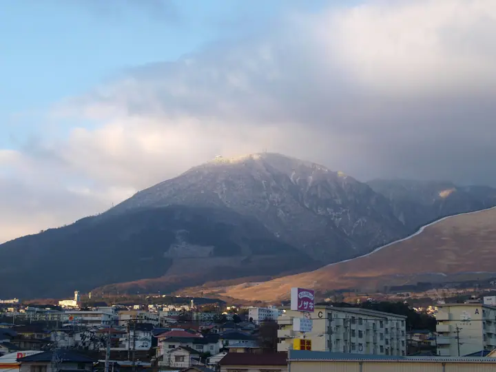
Mount Tsurumi live cameras
Mount Tsurumi hiking routes
- Beppu Short Walk from the Ropeway Top to the Rime and Azalea Summit of Mount Tsurumi above Beppu Bay 888 m · Ascent 72 m 鶴見山上駅 (Aerialway station)
- Mount Tsurumi from Mitake Gongen Shrine 5.2 km · Ascent 684 m parking
- Mount Tsurumi and Minamidai Circuit from Hono-Honome Shrine 6.7 km · Ascent 767 m parking
Hiking times are estimates calculated from the terrain.
Huts, campsites and lodging near Mount Tsurumi
Lodging
- A Hotel
- JZauruSS Hotel
- Venus Hotel
- Hozanso
- 杉乃井ホテル
Lists that include Mount Tsurumi
Japan's 300 Famous Mountains · 100 Low Mountains of Japan · Kyushu 100 Famous Mountains · Oita 100 Mountains · Elevations of 1003 Mountains of Japan
Mount Tsurumi facts
- Elevation
- 1,375 m
- Location
- Beppu, Oita
33.286584, 131.429744 - National Park
- 阿蘇くじゅう国立公園
- Volcano
- Active volcano (鶴見岳・伽藍岳)
- Website
- www.visit-oita.jp
- Trail Map
- www.city.beppu.oita.jp
- Wikipedia
- ja.wikipedia.org