
Mount Waga
和賀岳
Nishiwaga, Iwate · Elevation 1,439 m
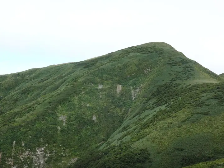
Mount Waga is a 1,440.2 m peak on the Iwate–Akita border, the principal summit of the Waga-Sankai massif within the Mahiru-sanchi mountains of the Ōu Range; the top sits where Nishiwaga Town in Iwate's Waga District meets Semboku City in Akita. Listed in the Nihon Nihyaku Meizan, the Tōhoku Hyakumeizan, and the Iwate Hyakumeizan, it forms part of the main Pacific–Sea-of-Japan watershed divide. The surrounding old-growth beech forest is protected as the national Waga-dake Wilderness Area; uncommonly for the Tōhoku highlands, the range lacks Aomori spruce, giving it a distinctive flora that includes Nikkō-kisuge, Hakusan-chidori, and Chinguruma. Two long approaches reach the summit—the Kōge route from the Iwate side and the Maki forest-road trail from Semboku on the Akita side—both demanding routes of eight to ten hours recommended for experienced hikers. The practical climbing season runs from June through October.
Mount Waga at a glance
- Weather: The most settled day in the next 7 days is Wed, November 4: clear, gusts up to 11 m/s. Fri, Nov 6, Sat, Nov 7, Sun, Nov 8: strong wind (gusts up to 26 m/s).
Mount Waga weather (hourly, 14 days)
Sunrise today 06:07, sunset 16:35
| Tue, 11/3 | Wed, 11/4 | Thu, 11/5 | Fri, 11/6 | Sat, 11/7 | Sun, 11/8 | Mon, 11/9 | Tue, 11/10 | Wed, 11/11 | Thu, 11/12 | Fri, 11/13 | Sat, 11/14 | Sun, 11/15 | Mon, 11/16 | Tue, 11/17 | |||||||||||||||||||||||||||||||||||||||||||||||||||||||||||||||||||||||
|---|---|---|---|---|---|---|---|---|---|---|---|---|---|---|---|---|---|---|---|---|---|---|---|---|---|---|---|---|---|---|---|---|---|---|---|---|---|---|---|---|---|---|---|---|---|---|---|---|---|---|---|---|---|---|---|---|---|---|---|---|---|---|---|---|---|---|---|---|---|---|---|---|---|---|---|---|---|---|---|---|---|---|---|---|---|
| Japan time | 15 | 17 | 19 | 21 | 23 | 1 | 3 | 5 | 7 | 9 | 11 | 13 | 15 | 18 | 21 | 0 | 3 | 6 | 9 | 12 | 15 | 18 | 21 | 0 | 3 | 6 | 9 | 12 | 15 | 18 | 21 | 0 | 3 | 6 | 9 | 12 | 15 | 18 | 21 | 0 | 3 | 6 | 9 | 12 | 15 | 18 | 21 | 0 | 3 | 6 | 9 | 15 | 21 | 3 | 9 | 15 | 21 | 3 | 9 | 15 | 21 | 3 | 9 | 15 | 21 | 3 | 9 | 15 | 21 | 3 | 9 | 15 | 21 | 3 | 9 | 15 | 21 | 3 | 9 | 15 | 21 | 3 | 9 | 15 | |
 |  | |   | |   |   |   |   | | | | | | | | | |   | | | | | | | | | | | | |   | |   |   |   | | |   | | | |   |   |   | | |   | | | | | | | | | | |   |   | | | | | | | | | | | | |  | | | | | | | |   | | | | ||
| Temperature | °C | 3° | 1° | 0° | -1° | -2° | -1° | -1° | 0° | 1° | 4° | 6° | 7° | 6° | 2° | 1° | 0° | 1° | 2° | 4° | 6° | 6° | 5° | 5° | 6° | 5° | 6° | 7° | 7° | 6° | 3° | 0° | -2° | -3° | -4° | -3° | -2° | -3° | -4° | -3° | -3° | -4° | -3° | -1° | -1° | -1° | -2° | -3° | -4° | -4° | -5° | -1° | -1° | -5° | -6° | -1° | 2° | -2° | -1° | 0° | 0° | -4° | -5° | -1° | 1° | -1° | -1° | -2° | -1° | -5° | -6° | -1° | 2° | -3° | -4° | 4° | 6° | 2° | 2° | 5° | 1° | -5° | -5° | -2° | 0° |
| Precipitation | mm | 0.5 | 1.0 | 1.1 | 3.7 | 3.6 | 1.1 | 0.2 | 0.4 | 1.6 | 1.3 | 0.4 | 2.4 | 5 | 3.2 | 2.4 | 2.4 | 2.0 | 2.6 | 2.7 | 1.7 | 1.9 | 2.0 | 1.7 | 0.6 | 0.4 | 0.7 | 0.6 | 0.1 | 1.9 | 8 | 4.3 | 1.1 | 0.1 | 0.2 | 6 | 0.3 | 0.2 | 4.8 | 3.6 | 2.9 | 3.1 | |||||||||||||||||||||||||||||||||||||||||||
| New snow | cm | <.1 | 1.4 | 2.3 | 1.7 | 1.7 | 1.9 | 1.7 | 0.6 | 0.4 | 0.6 | 0.6 | <.1 | 0.1 | 1.3 | 1.5 | 0.3 | 0.4 | |||||||||||||||||||||||||||||||||||||||||||||||||||||||||||||||||||
| Snow depth | cm | 0 | 0 | 0 | 0 | 0 | 0 | 0 | 0 | 0 | 0 | 0 | 0 | 0 | 0 | 0 | 0 | 0 | 0 | 0 | 0 | 0 | 0 | 0 | 0 | 0 | 0 | 0 | 0 | 0 | 0 | 0 | 0 | <1 | 2 | 3 | 3 | 3 | 4 | 4 | 4 | 4 | 4 | 4 | 3 | 3 | 2 | 2 | 2 | 2 | 2 | 2 | 1 | 1 | 1 | <1 | <1 | 1 | 1 | <1 | <1 | <1 | <1 | <1 | <1 | <1 | 0 | 0 | 0 | 0 | 0 | 0 | 0 | 0 | 0 | 0 | 0 | 0 | 0 | 0 | 0 | 0 | 0 | 0 | 0 |
| Wind | m/s | 6 | 4 | 3 | 2 | 1 | 2 | 1 | 2 | 2 | 2 | 3 | 4 | 2 | 1 | 1 | 2 | 2 | 2 | 2 | 2 | 2 | 2 | 1 | 1 | 1 | 1 | 2 | 6 | 6 | 5 | 6 | 4 | 4 | 3 | 6 | 7 | 6 | 6 | 7 | 7 | 6 | 6 | 8 | 9 | 7 | 5 | 4 | 2 | 2 | 1 | 3 | 3 | 0 | 1 | 1 | 5 | 4 | 1 | 2 | 2 | 0 | 1 | 2 | 4 | 1 | 1 | 4 | 5 | 2 | 1 | 2 | 3 | 0 | 0 | 1 | 1 | 3 | 1 | 1 | 4 | 4 | 2 | 2 | 3 |
| Wind gusts | m/s | 17 | 16 | 12 | 11 | 8 | 8 | 9 | 9 | 9 | 9 | 9 | 11 | 11 | 6 | 5 | 6 | 7 | 8 | 7 | 6 | 6 | 6 | 5 | 5 | 6 | 6 | 8 | 19 | 21 | 18 | 18 | 18 | 14 | 15 | 20 | 25 | 26 | 24 | 22 | 21 | 20 | 19 | 23 | 26 | 26 | 21 | 16 | 13 | 9 | 8 | 10 | 12 | 10 | 4 | 4 | 13 | 18 | 13 | 9 | 9 | 8 | 4 | 7 | 12 | 11 | 6 | 11 | 15 | 14 | 8 | 6 | 8 | 7 | 3 | 3 | 7 | 9 | 9 | 5 | 13 | 15 | 14 | 8 | 11 |
| Wind dir. | ↓ | ↓ | ↓ | ↓ | ↓ | ↓ | ↓ | ↓ | ↓ | ↓ | ↓ | ↓ | ↓ | ↓ | ↓ | ↓ | ↓ | ↓ | ↓ | ↓ | ↓ | ↓ | ↓ | ↓ | ↓ | ↓ | ↓ | ↓ | ↓ | ↓ | ↓ | ↓ | ↓ | ↓ | ↓ | ↓ | ↓ | ↓ | ↓ | ↓ | ↓ | ↓ | ↓ | ↓ | ↓ | ↓ | ↓ | ↓ | ↓ | ↓ | ↓ | ↓ | ↓ | ↓ | ↓ | ↓ | ↓ | ↓ | ↓ | ↓ | ↓ | ↓ | ↓ | ↓ | ↓ | ↓ | ↓ | ↓ | ↓ | ↓ | ↓ | ↓ | ↓ | ↓ | ↓ | ↓ | ↓ | ↓ | ↓ | ↓ | ↓ | ↓ | ↓ | ↓ | |
Lists that include Mount Waga
Japan 200 Famous Mountains · Japan's 300 Famous Mountains · Tohoku 100 Famous Mountains · Iwate 100 Famous Mountains · Elevations of 1003 Mountains of Japan · 1000 Mountains of Japan
Mount Waga facts
- Elevation
- 1,439 m
- Location
- Nishiwaga, Iwate
39.570433, 140.754266 - Website
- yamanoideyu.com
- Trail Map
- www.town.nishiwaga.lg.jp (PDF)
- Access Information
- www.town.nishiwaga.lg.jp
- Wikipedia
- ja.wikipedia.org