
Mount Waga
和賀岳
นิชิวางะ, อิวาเตะ · ความสูง 1,439 ม.
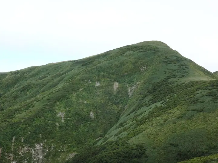
Mount Waga is a 1,440.2 m peak on the Iwate–Akita border, the principal summit of the Waga-Sankai massif within the Mahiru-sanchi mountains of the Ōu Range; the top sits where Nishiwaga Town in Iwate's Waga District meets Semboku City in Akita. Listed in the Nihon Nihyaku Meizan, the Tōhoku Hyakumeizan, and the Iwate Hyakumeizan, it forms part of the main Pacific–Sea-of-Japan watershed divide. The surrounding old-growth beech forest is protected as the national Waga-dake Wilderness Area; uncommonly for the Tōhoku highlands, the range lacks Aomori spruce, giving it a distinctive flora that includes Nikkō-kisuge, Hakusan-chidori, and Chinguruma. Two long approaches reach the summit—the Kōge route from the Iwate side and the Maki forest-road trail from Semboku on the Akita side—both demanding routes of eight to ten hours recommended for experienced hikers. The practical climbing season runs from June through October.
สรุป Mount Waga
- อากาศ: วันที่อากาศคงที่ที่สุดใน 7 วันข้างหน้าคือ พุธ 4 พฤศจิกายน: ท้องฟ้าแจ่มใส ลมกระโชกสูงสุด 11 ม./วินาที ศุกร์ 6 พ.ย., เสาร์ 7 พ.ย., อาทิตย์ 8 พ.ย. ลมแรง (ลมกระโชกสูงสุด 26 ม./วินาที)
อากาศ Mount Waga (รายชั่วโมง 2 สัปดาห์)
วันนี้พระอาทิตย์ขึ้น 06:07 ตก 16:35
| อังคาร 3/11 | พุธ 4/11 | พฤหัส 5/11 | ศุกร์ 6/11 | เสาร์ 7/11 | อาทิตย์ 8/11 | จันทร์ 9/11 | อังคาร 10/11 | พุธ 11/11 | พฤหัส 12/11 | ศุกร์ 13/11 | เสาร์ 14/11 | อาทิตย์ 15/11 | จันทร์ 16/11 | อังคาร 17/11 | |||||||||||||||||||||||||||||||||||||||||||||||||||||||||||||||||||||||
|---|---|---|---|---|---|---|---|---|---|---|---|---|---|---|---|---|---|---|---|---|---|---|---|---|---|---|---|---|---|---|---|---|---|---|---|---|---|---|---|---|---|---|---|---|---|---|---|---|---|---|---|---|---|---|---|---|---|---|---|---|---|---|---|---|---|---|---|---|---|---|---|---|---|---|---|---|---|---|---|---|---|---|---|---|---|
| เวลาญี่ปุ่น | 15 | 17 | 19 | 21 | 23 | 1 | 3 | 5 | 7 | 9 | 11 | 13 | 15 | 18 | 21 | 0 | 3 | 6 | 9 | 12 | 15 | 18 | 21 | 0 | 3 | 6 | 9 | 12 | 15 | 18 | 21 | 0 | 3 | 6 | 9 | 12 | 15 | 18 | 21 | 0 | 3 | 6 | 9 | 12 | 15 | 18 | 21 | 0 | 3 | 6 | 9 | 15 | 21 | 3 | 9 | 15 | 21 | 3 | 9 | 15 | 21 | 3 | 9 | 15 | 21 | 3 | 9 | 15 | 21 | 3 | 9 | 15 | 21 | 3 | 9 | 15 | 21 | 3 | 9 | 15 | 21 | 3 | 9 | 15 | |
 |  | |   | |   |   |   |   | | | | | | | | | |   | | | | | | | | | | | | |   | |   |   |   | | |   | | | |   |   |   | | |   | | | | | | | | | | |   |   | | | | | | | | | | | | |  | | | | | | | |   | | | | ||
| อุณหภูมิ | °C | 3° | 1° | 0° | -1° | -2° | -1° | -1° | 0° | 1° | 4° | 6° | 7° | 6° | 2° | 1° | 0° | 1° | 2° | 4° | 6° | 6° | 5° | 5° | 6° | 5° | 6° | 7° | 7° | 6° | 3° | 0° | -2° | -3° | -4° | -3° | -2° | -3° | -4° | -3° | -3° | -4° | -3° | -1° | -1° | -1° | -2° | -3° | -4° | -4° | -5° | -1° | -1° | -5° | -6° | -1° | 2° | -2° | -1° | 0° | 0° | -4° | -5° | -1° | 1° | -1° | -1° | -2° | -1° | -5° | -6° | -1° | 2° | -3° | -4° | 4° | 6° | 2° | 2° | 5° | 1° | -5° | -5° | -2° | 0° |
| ฝนและหิมะ | mm | 0.5 | 1.0 | 1.1 | 3.7 | 3.6 | 1.1 | 0.2 | 0.4 | 1.6 | 1.3 | 0.4 | 2.4 | 5 | 3.2 | 2.4 | 2.4 | 2.0 | 2.6 | 2.7 | 1.7 | 1.9 | 2.0 | 1.7 | 0.6 | 0.4 | 0.7 | 0.6 | 0.1 | 1.9 | 8 | 4.3 | 1.1 | 0.1 | 0.2 | 6 | 0.3 | 0.2 | 4.8 | 3.6 | 2.9 | 3.1 | |||||||||||||||||||||||||||||||||||||||||||
| หิมะตก | cm | <.1 | 1.4 | 2.3 | 1.7 | 1.7 | 1.9 | 1.7 | 0.6 | 0.4 | 0.6 | 0.6 | <.1 | 0.1 | 1.3 | 1.5 | 0.3 | 0.4 | |||||||||||||||||||||||||||||||||||||||||||||||||||||||||||||||||||
| หิมะสะสม | cm | 0 | 0 | 0 | 0 | 0 | 0 | 0 | 0 | 0 | 0 | 0 | 0 | 0 | 0 | 0 | 0 | 0 | 0 | 0 | 0 | 0 | 0 | 0 | 0 | 0 | 0 | 0 | 0 | 0 | 0 | 0 | 0 | <1 | 2 | 3 | 3 | 3 | 4 | 4 | 4 | 4 | 4 | 4 | 3 | 3 | 2 | 2 | 2 | 2 | 2 | 2 | 1 | 1 | 1 | <1 | <1 | 1 | 1 | <1 | <1 | <1 | <1 | <1 | <1 | <1 | 0 | 0 | 0 | 0 | 0 | 0 | 0 | 0 | 0 | 0 | 0 | 0 | 0 | 0 | 0 | 0 | 0 | 0 | 0 |
| ลม | m/s | 6 | 4 | 3 | 2 | 1 | 2 | 1 | 2 | 2 | 2 | 3 | 4 | 2 | 1 | 1 | 2 | 2 | 2 | 2 | 2 | 2 | 2 | 1 | 1 | 1 | 1 | 2 | 6 | 6 | 5 | 6 | 4 | 4 | 3 | 6 | 7 | 6 | 6 | 7 | 7 | 6 | 6 | 8 | 9 | 7 | 5 | 4 | 2 | 2 | 1 | 3 | 3 | 0 | 1 | 1 | 5 | 4 | 1 | 2 | 2 | 0 | 1 | 2 | 4 | 1 | 1 | 4 | 5 | 2 | 1 | 2 | 3 | 0 | 0 | 1 | 1 | 3 | 1 | 1 | 4 | 4 | 2 | 2 | 3 |
| ลมกระโชก | m/s | 17 | 16 | 12 | 11 | 8 | 8 | 9 | 9 | 9 | 9 | 9 | 11 | 11 | 6 | 5 | 6 | 7 | 8 | 7 | 6 | 6 | 6 | 5 | 5 | 6 | 6 | 8 | 19 | 21 | 18 | 18 | 18 | 14 | 15 | 20 | 25 | 26 | 24 | 22 | 21 | 20 | 19 | 23 | 26 | 26 | 21 | 16 | 13 | 9 | 8 | 10 | 12 | 10 | 4 | 4 | 13 | 18 | 13 | 9 | 9 | 8 | 4 | 7 | 12 | 11 | 6 | 11 | 15 | 14 | 8 | 6 | 8 | 7 | 3 | 3 | 7 | 9 | 9 | 5 | 13 | 15 | 14 | 8 | 11 |
| ทิศทางลม | ↓ | ↓ | ↓ | ↓ | ↓ | ↓ | ↓ | ↓ | ↓ | ↓ | ↓ | ↓ | ↓ | ↓ | ↓ | ↓ | ↓ | ↓ | ↓ | ↓ | ↓ | ↓ | ↓ | ↓ | ↓ | ↓ | ↓ | ↓ | ↓ | ↓ | ↓ | ↓ | ↓ | ↓ | ↓ | ↓ | ↓ | ↓ | ↓ | ↓ | ↓ | ↓ | ↓ | ↓ | ↓ | ↓ | ↓ | ↓ | ↓ | ↓ | ↓ | ↓ | ↓ | ↓ | ↓ | ↓ | ↓ | ↓ | ↓ | ↓ | ↓ | ↓ | ↓ | ↓ | ↓ | ↓ | ↓ | ↓ | ↓ | ↓ | ↓ | ↓ | ↓ | ↓ | ↓ | ↓ | ↓ | ↓ | ↓ | ↓ | ↓ | ↓ | ↓ | ↓ | |
รายชื่อที่มี Mount Waga
200 ภูเขาที่มีชื่อเสียงของญี่ปุ่น · 300 ภูเขาที่มีชื่อเสียงของญี่ปุ่น · 100 ภูเขาที่มีชื่อเสียงของโทโฮกุ · 100 ภูเขาที่มีชื่อเสียงของอิวาเตะ · ระดับความสูงของภูเขา 1003 แห่งในญี่ปุ่น · ภูเขา 1000 แห่งของญี่ปุ่น
ข้อมูลพื้นฐาน Mount Waga
- ความสูง
- 1,439 ม.
- ที่ตั้ง
- นิชิวางะ, อิวาเตะ
39.570433, 140.754266 - เว็บไซต์
- yamanoideyu.com
- แผนที่เส้นทางเดินเขา
- www.town.nishiwaga.lg.jp (PDF)
- ข้อมูลการเดินทาง
- www.town.nishiwaga.lg.jp
- วิกิพีเดีย
- ja.wikipedia.org