
Mount Osutaka
御巣鷹山
Fujikawaguchiko, Yamanashi · Elevation 1,775 m
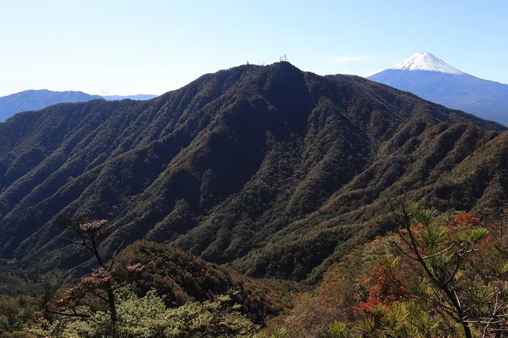
Mount Osutaka is a 1,775-metre peak on the boundary between Fujikawaguchiko Town and Tsuru City in Yamanashi Prefecture, part of the Misaka Range. Together with the higher Kaiun-zan (1,785 m) and Kinashi-yama (1,730 m), it forms the three-peak massif collectively known as Mitsutōge-yama, and its summit hosts a radio-relay reflector. Selected for the Tsuru City Twenty-One Distinguished Peaks list, it is most often climbed via the traverse from Kaiun-zan or the steep North-Mouth Trail on the Tsuru side.
Mount Osutaka at a glance
- Weather: The most settled day in the next 7 days is Fri, November 6: clear, gusts up to 6 m/s.
- Route: The shortest is Mitsutoge Three Peaks from Kanegakubosawa Trailhead: about 4 h 28 min, 7.5 km, about 570 m of climbing.
Mount Osutaka weather (hourly, 14 days)
Sunrise today 06:08, sunset 16:49
| Tue, 11/3 | Wed, 11/4 | Thu, 11/5 | Fri, 11/6 | Sat, 11/7 | Sun, 11/8 | Mon, 11/9 | Tue, 11/10 | Wed, 11/11 | Thu, 11/12 | Fri, 11/13 | Sat, 11/14 | Sun, 11/15 | Mon, 11/16 | Tue, 11/17 | |||||||||||||||||||||||||||||||||||||||||||||||||||||||||||||||||||||||
|---|---|---|---|---|---|---|---|---|---|---|---|---|---|---|---|---|---|---|---|---|---|---|---|---|---|---|---|---|---|---|---|---|---|---|---|---|---|---|---|---|---|---|---|---|---|---|---|---|---|---|---|---|---|---|---|---|---|---|---|---|---|---|---|---|---|---|---|---|---|---|---|---|---|---|---|---|---|---|---|---|---|---|---|---|---|
| Japan time | 15 | 17 | 19 | 21 | 23 | 1 | 3 | 5 | 7 | 9 | 11 | 13 | 15 | 18 | 21 | 0 | 3 | 6 | 9 | 12 | 15 | 18 | 21 | 0 | 3 | 6 | 9 | 12 | 15 | 18 | 21 | 0 | 3 | 6 | 9 | 12 | 15 | 18 | 21 | 0 | 3 | 6 | 9 | 12 | 15 | 18 | 21 | 0 | 3 | 6 | 9 | 15 | 21 | 3 | 9 | 15 | 21 | 3 | 9 | 15 | 21 | 3 | 9 | 15 | 21 | 3 | 9 | 15 | 21 | 3 | 9 | 15 | 21 | 3 | 9 | 15 | 21 | 3 | 9 | 15 | 21 | 3 | 9 | 15 | |
  |   | | |   | | | |   | | | | | | | | | |   |   | | | | |   |  |  | | | | | | | | | | |   | |   | | | |   | | | | | | | | | | | |   | | | | |   |  | | | | | | | | | | | | | | | | | | | | | | | ||
| Temperature | °C | 6° | 4° | 4° | 3° | 3° | 2° | 2° | 1° | 1° | 2° | 4° | 3° | 2° | 1° | 1° | 2° | 2° | 3° | 6° | 11° | 8° | 6° | 5° | 3° | 3° | 3° | 9° | 14° | 13° | 7° | 5° | 3° | 3° | -1° | 5° | 8° | 7° | 1° | 0° | 1° | 0° | 0° | 4° | 8° | 5° | 2° | 2° | 1° | 0° | 0° | 1° | 3° | 0° | -1° | 0° | 5° | -1° | -2° | 0° | 4° | -3° | -5° | 2° | 5° | 0° | -3° | 3° | 6° | -1° | -2° | 1° | 4° | -1° | -2° | 5° | 9° | 4° | 3° | 8° | 12° | 2° | 2° | -1° | 3° |
| Precipitation | mm | 1.1 | 0.9 | 0.4 | 0.2 | 0.2 | 0.2 | 0.2 | 0.5 | 1.5 | 10 | 15 | 12 | 3.9 | 1.5 | 2.3 | 0.1 | 0.2 | 0.2 | 0.4 | 0.1 | 0.1 | 0.2 | 0.2 | 7 | 19 | 0.4 | 0.2 | |||||||||||||||||||||||||||||||||||||||||||||||||||||||||
| New snow | cm | ||||||||||||||||||||||||||||||||||||||||||||||||||||||||||||||||||||||||||||||||||||
| Snow depth | cm | 0 | 0 | 0 | 0 | 0 | 0 | 0 | 0 | 0 | 0 | 0 | 0 | 0 | 0 | 0 | 0 | 0 | 0 | 0 | 0 | 0 | 0 | 0 | 0 | 0 | 0 | 0 | 0 | 0 | 0 | 0 | 0 | 0 | 0 | 0 | 0 | 0 | 0 | 0 | 0 | 0 | 0 | 0 | 0 | 0 | 0 | 0 | 0 | 0 | 0 | 0 | 0 | 0 | 0 | 0 | 0 | 0 | 0 | 0 | 0 | 0 | 0 | 0 | 0 | 0 | 0 | 0 | 0 | 0 | 0 | 0 | 0 | 0 | 0 | 0 | 0 | 0 | 0 | 0 | 0 | 0 | 0 | 0 | 0 |
| Wind | m/s | 2 | 1 | 2 | 1 | 1 | 1 | 1 | 1 | 1 | 1 | 2 | 2 | 2 | 2 | 1 | 1 | 1 | 1 | 0 | 1 | 1 | 1 | 0 | 1 | 1 | 1 | 2 | 1 | 1 | 0 | 1 | 1 | 1 | 2 | 2 | 2 | 1 | 1 | 0 | 0 | 0 | 0 | 0 | 1 | 3 | 2 | 1 | 1 | 1 | 1 | 1 | 3 | 2 | 2 | 2 | 3 | 1 | 1 | 5 | 4 | 1 | 1 | 1 | 1 | 1 | 1 | 2 | 1 | 1 | 0 | 1 | 1 | 0 | 1 | 1 | 0 | 1 | 1 | 1 | 2 | 2 | 1 | 1 | 2 |
| Wind gusts | m/s | 6 | 5 | 4 | 4 | 4 | 3 | 4 | 4 | 4 | 5 | 6 | 6 | 6 | 6 | 6 | 5 | 6 | 5 | 4 | 5 | 5 | 5 | 3 | 5 | 6 | 6 | 6 | 6 | 6 | 3 | 3 | 4 | 5 | 6 | 7 | 7 | 7 | 5 | 3 | 3 | 3 | 2 | 3 | 4 | 10 | 9 | 5 | 3 | 3 | 3 | 4 | 9 | 7 | 5 | 6 | 8 | 8 | 6 | 19 | 18 | 12 | 4 | 4 | 5 | 6 | 4 | 7 | 11 | 6 | 4 | 4 | 5 | 5 | 5 | 5 | 7 | 4 | 8 | 6 | 9 | 8 | 6 | 5 | 6 |
| Wind dir. | ↓ | ↓ | ↓ | ↓ | ↓ | ↓ | ↓ | ↓ | ↓ | ↓ | ↓ | ↓ | ↓ | ↓ | ↓ | ↓ | ↓ | ↓ | ↓ | ↓ | ↓ | ↓ | ↓ | ↓ | ↓ | ↓ | ↓ | ↓ | ↓ | ↓ | ↓ | ↓ | ↓ | ↓ | ↓ | ↓ | ↓ | ↓ | ↓ | ↓ | ↓ | ↓ | ↓ | ↓ | ↓ | ↓ | ↓ | ↓ | ↓ | ↓ | ↓ | ↓ | ↓ | ↓ | ↓ | ↓ | ↓ | ↓ | ↓ | ↓ | ↓ | ↓ | ↓ | ↓ | ↓ | ↓ | ↓ | ↓ | ↓ | ↓ | ↓ | ↓ | ↓ | ↓ | ↓ | ↓ | ↓ | ↓ | ↓ | ↓ | ↓ | ||||
Mount Osutaka hiking routes
- Mitsutoge Three Peaks from Kanegakubosawa Trailhead 7.5 km · Ascent 574 m parking
- Mount Mitsutoge, Mount Osutaka, and Mount Obata Circuit 8.3 km · Ascent 688 m parking
Hiking times are estimates calculated from the terrain.
Huts, campsites and lodging near Mount Osutaka
Mountain huts
- 四季楽園 2026: open all year · reservation required · sleeps 200
- 三ッ峠山荘 2026: open all year · reservation required · sleeps 50
Campsites
- 宝の山ふれあいの里キャンプ場
- カームヴィレッジ (Calm Village)
- Camping Mahoroba
- ban
Lodging
- Word heritage Fujisan
- Lake Villa KAWAGUCHIKO
Lists that include Mount Osutaka
Mount Osutaka facts
- Elevation
- 1,775 m
- Location
- Fujikawaguchiko, Yamanashi
35.553854, 138.807905 - Website
- www.yamanashi-kankou.jp
- Trail Map
- www.pref.yamanashi.jp (PDF)
- Wikipedia
- ja.wikipedia.org