
Mount Nikoro
仁頃山
Saroma, Hokkaido / Kitami, Hokkaido · Elevation 829 m
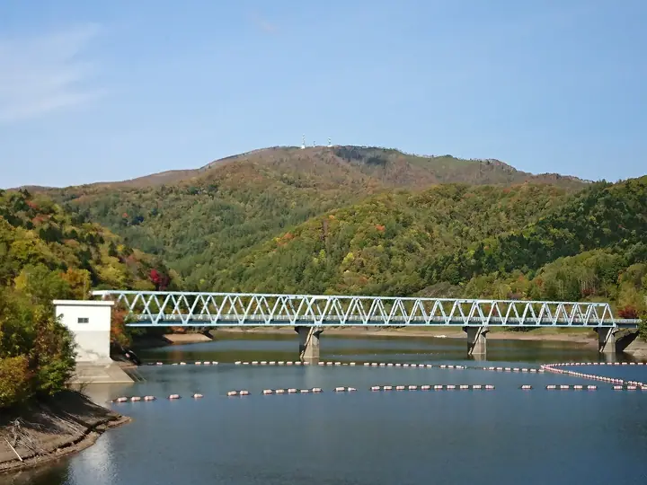
Mount Nikoro (829.2 m) straddles Kitami City and Saroma Town in Hokkaidō's Kitami Mountain range. Because no higher peaks rise nearby, the summit gives wide views over the surrounding lowlands, and the mountain is treasured as a local hiking destination by Kitami residents. Six maintained trails — kept up by the Nikoro-yama Aikōkai (Nikoro Mountain Friends Association) — climb the peak from the Tomisato-ko Forest Park and other trailheads.
Mount Nikoro at a glance
- Weather: The most settled day in the next 7 days is Thu, November 5: clear, gusts up to 10 m/s. Wed, Nov 4, Sat, Nov 7, Sun, Nov 8: strong wind (gusts up to 20 m/s).
- Route: The shortest is Mount Nikoro Return up the Switchback Service Road to a Lone Summit with a 360-degree View: about 2 h 27 min, 6.4 km, about 580 m of climbing.
Mount Nikoro weather (hourly, 14 days)
Sunrise today 06:03, sunset 16:15
| Tue, 11/3 | Wed, 11/4 | Thu, 11/5 | Fri, 11/6 | Sat, 11/7 | Sun, 11/8 | Mon, 11/9 | Tue, 11/10 | Wed, 11/11 | Thu, 11/12 | Fri, 11/13 | Sat, 11/14 | Sun, 11/15 | Mon, 11/16 | Tue, 11/17 | |||||||||||||||||||||||||||||||||||||||||||||||||||||||||||||||||||||||
|---|---|---|---|---|---|---|---|---|---|---|---|---|---|---|---|---|---|---|---|---|---|---|---|---|---|---|---|---|---|---|---|---|---|---|---|---|---|---|---|---|---|---|---|---|---|---|---|---|---|---|---|---|---|---|---|---|---|---|---|---|---|---|---|---|---|---|---|---|---|---|---|---|---|---|---|---|---|---|---|---|---|---|---|---|---|
| Japan time | 21 | 23 | 1 | 3 | 5 | 7 | 9 | 11 | 13 | 15 | 17 | 19 | 21 | 0 | 3 | 6 | 9 | 12 | 15 | 18 | 21 | 0 | 3 | 6 | 9 | 12 | 15 | 18 | 21 | 0 | 3 | 6 | 9 | 12 | 15 | 18 | 21 | 0 | 3 | 6 | 9 | 12 | 15 | 18 | 21 | 0 | 3 | 6 | 9 | 12 | 15 | 21 | 3 | 9 | 15 | 21 | 3 | 9 | 15 | 21 | 3 | 9 | 15 | 21 | 3 | 9 | 15 | 21 | 3 | 9 | 15 | 21 | 3 | 9 | 15 | 21 | 3 | 9 | 15 | 21 | 3 | 9 | 15 | 21 | |
  |  | |   | |   | | |  | |  | | | | | | | |   | | |   |   | |   | |   | |   | | | | |   | |   |   | | | | | | | | |   | | |   | | | | | | | | | | | | |   | | | | | |   | | | | |  | | | | | |   |   | | | |  | ||
| Temperature | °C | -3° | -4° | -6° | -5° | -4° | -2° | 2° | 3° | 4° | 3° | -1° | -3° | -5° | -6° | -4° | -3° | 5° | 8° | 6° | 3° | 2° | 2° | 3° | 3° | 4° | 5° | 7° | 5° | 2° | 0° | -2° | -3° | -1° | 0° | -1° | -3° | -3° | -2° | -2° | -2° | -1° | 0° | -1° | -3° | -4° | -7° | -7° | -6° | -2° | -1° | -2° | -5° | -7° | -3° | -1° | -6° | -5° | -3° | -1° | -6° | -6° | -2° | 0° | -4° | -5° | -5° | -3° | -5° | -6° | -2° | 0° | -6° | -7° | 0° | 4° | 1° | 2° | 0° | -2° | -4° | -5° | -2° | -1° | -7° |
| Precipitation | mm | 1.1 | 2.6 | 4.1 | 2.6 | 0.3 | 0.2 | 0.1 | 0.1 | 0.2 | 0.2 | 0.2 | 0.1 | 0.1 | 0.4 | 0.1 | 0.2 | 0.3 | 0.4 | 1.1 | 3.6 | 2.8 | 0.5 | ||||||||||||||||||||||||||||||||||||||||||||||||||||||||||||||
| New snow | cm | <.1 | 0.1 | <.1 | 0.2 | 0.2 | 0.2 | 0.1 | <.1 | <.1 | 0.1 | 0.4 | <.1 | <.1 | 0.1 | 0.2 | 0.2 | 0.4 | 0.5 | 2.1 | 0.5 | ||||||||||||||||||||||||||||||||||||||||||||||||||||||||||||||||
| Snow depth | cm | 0 | 0 | 0 | 0 | 0 | 0 | 0 | 0 | 0 | 0 | 0 | 0 | 0 | 0 | 0 | 0 | 0 | 0 | 0 | 0 | 0 | 0 | 0 | 0 | 0 | 0 | 0 | 0 | 0 | 0 | 0 | 0 | 0 | 0 | 0 | 0 | 0 | 0 | 0 | 0 | 0 | 0 | 0 | 0 | 0 | 0 | 0 | 0 | 0 | 0 | 0 | 0 | 0 | 0 | 0 | 0 | 0 | <1 | <1 | <1 | <1 | <1 | <1 | <1 | <1 | <1 | <1 | <1 | <1 | <1 | <1 | <1 | <1 | <1 | <1 | 0 | 0 | 0 | 0 | 1 | 1 | 1 | 1 | 1 |
| Wind | m/s | 2 | 1 | 2 | 2 | 2 | 4 | 7 | 6 | 5 | 2 | 1 | 1 | 1 | 2 | 2 | 3 | 5 | 4 | 3 | 2 | 2 | 1 | 1 | 1 | 1 | 1 | 2 | 5 | 1 | 1 | 5 | 6 | 6 | 6 | 3 | 3 | 6 | 8 | 9 | 9 | 6 | 7 | 6 | 4 | 4 | 1 | 1 | 1 | 1 | 2 | 2 | 3 | 1 | 1 | 1 | 0 | 1 | 1 | 1 | 1 | 1 | 1 | 1 | 2 | 5 | 6 | 5 | 5 | 4 | 4 | 1 | 1 | 2 | 3 | 4 | 3 | 3 | 3 | 4 | 5 | 4 | 5 | 2 | 1 |
| Wind gusts | m/s | 6 | 4 | 4 | 4 | 5 | 8 | 16 | 17 | 15 | 11 | 4 | 3 | 3 | 4 | 5 | 7 | 9 | 10 | 9 | 8 | 5 | 4 | 3 | 3 | 3 | 4 | 6 | 11 | 12 | 4 | 10 | 13 | 15 | 15 | 14 | 9 | 16 | 17 | 20 | 21 | 20 | 17 | 17 | 14 | 9 | 8 | 4 | 4 | 5 | 6 | 7 | 10 | 7 | 4 | 4 | 5 | 2 | 4 | 5 | 3 | 3 | 4 | 7 | 7 | 10 | 13 | 14 | 15 | 11 | 9 | 11 | 3 | 4 | 8 | 9 | 8 | 9 | 8 | 9 | 10 | 11 | 12 | 12 | 4 |
| Wind dir. | ↓ | ↓ | ↓ | ↓ | ↓ | ↓ | ↓ | ↓ | ↓ | ↓ | ↓ | ↓ | ↓ | ↓ | ↓ | ↓ | ↓ | ↓ | ↓ | ↓ | ↓ | ↓ | ↓ | ↓ | ↓ | ↓ | ↓ | ↓ | ↓ | ↓ | ↓ | ↓ | ↓ | ↓ | ↓ | ↓ | ↓ | ↓ | ↓ | ↓ | ↓ | ↓ | ↓ | ↓ | ↓ | ↓ | ↓ | ↓ | ↓ | ↓ | ↓ | ↓ | ↓ | ↓ | ↓ | ↓ | ↓ | ↓ | ↓ | ↓ | ↓ | ↓ | ↓ | ↓ | ↓ | ↓ | ↓ | ↓ | ↓ | ↓ | ↓ | ↓ | ↓ | ↓ | ↓ | ↓ | ↓ | ↓ | ↓ | ↓ | ↓ | ↓ | ↓ | ↓ | |
Mount Nikoro hiking routes
Hiking times are estimates calculated from the terrain.
Huts, campsites and lodging near Mount Nikoro
Campsites
- 富里湖森林公園キャンプ場
Lists that include Mount Nikoro
Mount Nikoro facts
- Elevation
- 829 m
- Location
- Saroma, Hokkaido / Kitami, Hokkaido
43.878276, 143.718166 - Website
- nikoroyama.fc2.page
- Trail Map
- nikoroyama.web.fc2.com
- Wikipedia
- ja.wikipedia.org