
Mount Nanatsugatake
七ヶ岳
Minamiaizu, Fukushima · Elevation 1,636 m
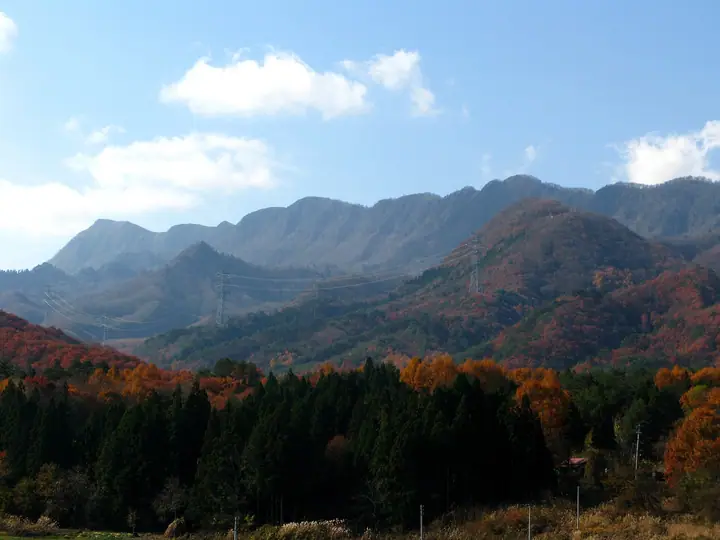
Mount Nanatsugatake is a 1,635.8 m peak in the centre of Minamiaizu Town in Minamiaizu District, Fukushima Prefecture. As its name ("seven peaks") suggests, the summit ridge is a chain of seven prominent rises, and the mountain carries a first-order triangulation marker. It is listed in the Nihon Sanbyaku Meizan, the Ittō-Sankakuten Hyakumeizan, the Tōhoku 100 Meizan, the Utsukushima 100 Meizan, and the Aizu Hyakumeizan. The two principal routes climb from the Kuromorisawa trailhead, passing the impressive Goma-daki Falls along the stream, and from the Takatsue trailhead beside Takatsue Ski Resort over Takakura-yama to the main ridge. Mid-June brings broad bloomings of urajiroyōraku, and the summit panorama spans the Nasu Range, the Oga massif, Aizu-Komagatake, and Hiuchigatake. Forest-road work occasionally restricts access from one trailhead or another, so checking with the Minamiaizu Tourism and Products Association in advance is recommended.
Mount Nanatsugatake at a glance
- Weather: The most settled day in the next 7 days is Mon, November 9: cloudy, gusts up to 10 m/s. Fri, Nov 6, Sat, Nov 7, Sun, Nov 8: strong wind (gusts up to 19 m/s).
Mount Nanatsugatake weather (hourly, 14 days)
Sunrise today 06:07, sunset 16:43
| Tue, 11/3 | Wed, 11/4 | Thu, 11/5 | Fri, 11/6 | Sat, 11/7 | Sun, 11/8 | Mon, 11/9 | Tue, 11/10 | Wed, 11/11 | Thu, 11/12 | Fri, 11/13 | Sat, 11/14 | Sun, 11/15 | Mon, 11/16 | Tue, 11/17 | |||||||||||||||||||||||||||||||||||||||||||||||||||||||||||||||||||||||
|---|---|---|---|---|---|---|---|---|---|---|---|---|---|---|---|---|---|---|---|---|---|---|---|---|---|---|---|---|---|---|---|---|---|---|---|---|---|---|---|---|---|---|---|---|---|---|---|---|---|---|---|---|---|---|---|---|---|---|---|---|---|---|---|---|---|---|---|---|---|---|---|---|---|---|---|---|---|---|---|---|---|---|---|---|---|
| Japan time | 15 | 17 | 19 | 21 | 23 | 1 | 3 | 5 | 7 | 9 | 11 | 13 | 15 | 18 | 21 | 0 | 3 | 6 | 9 | 12 | 15 | 18 | 21 | 0 | 3 | 6 | 9 | 12 | 15 | 18 | 21 | 0 | 3 | 6 | 9 | 12 | 15 | 18 | 21 | 0 | 3 | 6 | 9 | 12 | 15 | 18 | 21 | 0 | 3 | 6 | 9 | 15 | 21 | 3 | 9 | 15 | 21 | 3 | 9 | 15 | 21 | 3 | 9 | 15 | 21 | 3 | 9 | 15 | 21 | 3 | 9 | 15 | 21 | 3 | 9 | 15 | 21 | 3 | 9 | 15 | 21 | 3 | 9 | 15 | |
  |  | | |   | | | |  | | | | |   |   | | | |   | |   |   | | | | |   | |   | | | | | |   | | |   | |   | | | | |   | | | | | | | | |   | | | | |   | | | | | | | | | | | | | |  | | | | | | | | |   | | | ||
| Temperature | °C | 5° | 2° | -1° | -2° | -3° | -3° | -4° | -4° | -2° | 4° | 7° | 9° | 7° | 3° | 2° | 3° | 4° | 4° | 6° | 8° | 9° | 5° | 6° | 5° | 2° | 3° | 8° | 9° | 9° | 5° | 3° | 1° | 0° | -1° | -2° | -2° | -2° | -2° | -3° | -3° | -3° | -3° | -1° | 1° | 1° | -1° | -1° | -2° | -2° | -2° | -1° | 3° | -1° | -4° | 2° | 4° | -1° | -2° | -1° | 0° | -2° | -2° | 1° | 2° | -4° | -3° | -1° | -1° | -3° | -3° | 0° | 6° | -4° | -6° | 5° | 8° | 2° | 4° | 6° | 3° | -2° | -4° | -1° | 2° |
| Precipitation | mm | 1.0 | 0.1 | 7 | 10 | 4.9 | 1.5 | 0.1 | 0.2 | 0.6 | 0.2 | 0.3 | 0.5 | 0.4 | 0.8 | 1.5 | 2.6 | 3.0 | 2.2 | 0.8 | 0.5 | 0.1 | 0.3 | 0.2 | 0.1 | 0.5 | 0.5 | 1.2 | 2.1 | 1.1 | 1.2 | 0.7 | 0.1 | 5 | 0.3 | 2.5 | 6 | 3.1 | 3.6 | 0.5 | |||||||||||||||||||||||||||||||||||||||||||||
| New snow | cm | 0.8 | 1.0 | 0.7 | <.1 | <.1 | <.1 | <.1 | <.1 | <.1 | <.1 | <.1 | 1.9 | 0.2 | |||||||||||||||||||||||||||||||||||||||||||||||||||||||||||||||||||||||
| Snow depth | cm | 0 | 0 | 0 | 0 | 0 | 0 | 0 | 0 | 0 | 0 | 0 | 0 | 0 | 0 | 0 | 0 | 0 | 0 | 0 | 0 | 0 | 0 | 0 | 0 | 0 | 0 | 0 | 0 | 0 | 0 | 0 | 0 | 0 | 0 | <1 | <1 | <1 | <1 | <1 | <1 | <1 | <1 | <1 | 0 | 0 | 0 | 0 | 0 | 0 | 0 | 0 | 0 | 0 | 0 | 0 | 0 | 0 | 0 | <1 | 0 | 0 | 0 | 0 | 0 | 0 | 0 | 0 | 0 | 0 | 0 | 0 | 0 | 0 | 0 | 0 | 0 | 0 | 0 | 0 | 0 | 0 | 0 | 0 | 0 |
| Wind | m/s | 4 | 3 | 1 | 0 | 0 | 0 | 0 | 0 | 1 | 1 | 1 | 1 | 4 | 4 | 5 | 5 | 3 | 2 | 2 | 1 | 0 | 2 | 1 | 0 | 0 | 0 | 3 | 6 | 5 | 5 | 4 | 6 | 5 | 5 | 5 | 4 | 5 | 5 | 5 | 5 | 5 | 4 | 4 | 6 | 5 | 2 | 1 | 1 | 2 | 1 | 1 | 3 | 2 | 1 | 1 | 5 | 3 | 4 | 7 | 7 | 5 | 3 | 3 | 4 | 1 | 0 | 5 | 6 | 4 | 2 | 2 | 2 | 2 | 2 | 2 | 1 | 2 | 2 | 0 | 6 | 6 | 4 | 2 | 2 |
| Wind gusts | m/s | 15 | 13 | 9 | 6 | 4 | 4 | 4 | 4 | 3 | 4 | 5 | 5 | 10 | 13 | 16 | 16 | 14 | 11 | 12 | 7 | 4 | 6 | 6 | 3 | 3 | 5 | 11 | 18 | 17 | 16 | 16 | 17 | 16 | 17 | 16 | 17 | 19 | 17 | 17 | 17 | 16 | 16 | 14 | 16 | 17 | 14 | 8 | 5 | 5 | 6 | 4 | 10 | 10 | 6 | 4 | 14 | 16 | 14 | 19 | 24 | 20 | 14 | 10 | 13 | 12 | 7 | 14 | 19 | 18 | 13 | 7 | 7 | 7 | 6 | 6 | 7 | 7 | 10 | 8 | 19 | 19 | 18 | 12 | 8 |
| Wind dir. | ↓ | ↓ | ↓ | ↓ | ↓ | ↓ | ↓ | ↓ | ↓ | ↓ | ↓ | ↓ | ↓ | ↓ | ↓ | ↓ | ↓ | ↓ | ↓ | ↓ | ↓ | ↓ | ↓ | ↓ | ↓ | ↓ | ↓ | ↓ | ↓ | ↓ | ↓ | ↓ | ↓ | ↓ | ↓ | ↓ | ↓ | ↓ | ↓ | ↓ | ↓ | ↓ | ↓ | ↓ | ↓ | ↓ | ↓ | ↓ | ↓ | ↓ | ↓ | ↓ | ↓ | ↓ | ↓ | ↓ | ↓ | ↓ | ↓ | ↓ | ↓ | ↓ | ↓ | ↓ | ↓ | ↓ | ↓ | ↓ | ↓ | ↓ | ↓ | ↓ | ↓ | ↓ | ↓ | ↓ | ↓ | ↓ | ↓ | ↓ | ↓ | ↓ | ↓ | ↓ | |
Huts, campsites and lodging near Mount Nanatsugatake
Lodging
- 会津アストリアホテル
Lists that include Mount Nanatsugatake
Japan's 300 Famous Mountains · 100 Famous Mountains with First-order Triangulation Points · Tohoku 100 Famous Mountains · Utsukushima 100 Famous Mountains (Fukushima Prefecture) · Aizu 100 Famous Mountains · Elevations of 1003 Mountains of Japan · 1000 Mountains of Japan
Mount Nanatsugatake facts
- Elevation
- 1,636 m
- Location
- Minamiaizu, Fukushima
37.124307, 139.657474 - Website
- www.town.minamiaizu.lg.jp
- Trail Map
- www.town.minamiaizu.lg.jp (PDF)
- Wikipedia
- ja.wikipedia.org