
Mount Miyanoura
宮之浦岳
Yakushima, Kagoshima · Elevation 1,936 m
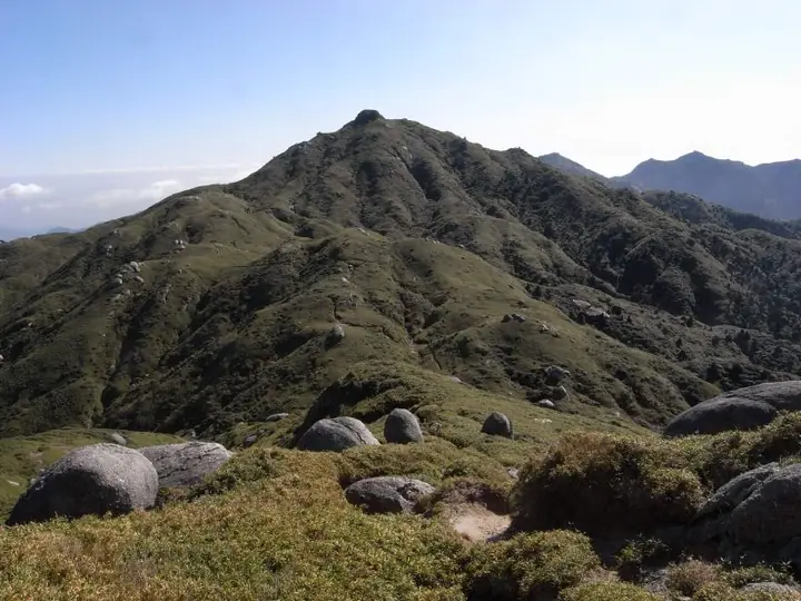
Mount Miyanoura is a 1,936 m peak in Yakushima Town, Kagoshima Prefecture, the highest summit on Yakushima Island and the highest mountain in the Kyushu region (including the mainland). It is also the highest peak in Kagoshima and is listed in Fukada Kyūya's Hyakumeizan and the Ittō-Sankakuten Hyakumeizan. As the centrepiece of Yakushima National Park, it lies within the core zone of the Yakushima World Heritage Site and is sometimes called the "Marine Alps" for its alpine character on an island in the open sea. Its summit ridges are dotted with weathered granite tors among Yakushi-zasa bamboo, and the slopes harbor the endemic Rhododendron yakushimanum and the Hananoego high-altitude wetlands. The standard route is the Ambō trail from the Yodogawa trailhead via Hananoego and Mount Kurio, often combined into a longer traverse linking Shiratani-Unsuikyō and the Jōmon-sugi cedar.
Mount Miyanoura at a glance
- Weather: The most settled day in the next 7 days is Sun, November 8: cloudy, gusts up to 9 m/s. Fri, Nov 6: strong wind (gusts up to 16 m/s).
- Route: The shortest is Mount Miyanoura Traverse from Yodogawa Trailhead to Shiratani Unsuikyo: about 15 h 21 min, 25.6 km, about 1,730 m of climbing.
Mount Miyanoura weather (hourly, 14 days)
Sunrise today 06:33, sunset 17:30
| Tue, 11/3 | Wed, 11/4 | Thu, 11/5 | Fri, 11/6 | Sat, 11/7 | Sun, 11/8 | Mon, 11/9 | Tue, 11/10 | Wed, 11/11 | Thu, 11/12 | Fri, 11/13 | Sat, 11/14 | Sun, 11/15 | Mon, 11/16 | Tue, 11/17 | |||||||||||||||||||||||||||||||||||||||||||||||||||||||||||||||||||||||
|---|---|---|---|---|---|---|---|---|---|---|---|---|---|---|---|---|---|---|---|---|---|---|---|---|---|---|---|---|---|---|---|---|---|---|---|---|---|---|---|---|---|---|---|---|---|---|---|---|---|---|---|---|---|---|---|---|---|---|---|---|---|---|---|---|---|---|---|---|---|---|---|---|---|---|---|---|---|---|---|---|---|---|---|---|---|
| Japan time | 15 | 17 | 19 | 21 | 23 | 1 | 3 | 5 | 7 | 9 | 11 | 13 | 15 | 18 | 21 | 0 | 3 | 6 | 9 | 12 | 15 | 18 | 21 | 0 | 3 | 6 | 9 | 12 | 15 | 18 | 21 | 0 | 3 | 6 | 9 | 12 | 15 | 18 | 21 | 0 | 3 | 6 | 9 | 12 | 15 | 18 | 21 | 0 | 3 | 6 | 9 | 15 | 21 | 3 | 9 | 15 | 21 | 3 | 9 | 15 | 21 | 3 | 9 | 15 | 21 | 3 | 9 | 15 | 21 | 3 | 9 | 15 | 21 | 3 | 9 | 15 | 21 | 3 | 9 | 15 | 21 | 3 | 9 | 15 | |
  |   |   | | | | |   |   |   | | | | | |   |   | | | | |   | | | | |   |  |   | | |  | | | | | | | | | | | | | | |   | | | | | | | | | | | | | | | | | | | | | | | | | | | | | | | | | | | | | | ||
| Temperature | °C | 11° | 10° | 7° | 7° | 7° | 8° | 7° | 8° | 7° | 11° | 14° | 14° | 14° | 10° | 9° | 8° | 8° | 7° | 12° | 16° | 14° | 11° | 11° | 11° | 10° | 10° | 10° | 12° | 12° | 9° | 8° | 5° | 4° | 3° | 6° | 8° | 8° | 3° | 2° | 2° | 3° | 3° | 9° | 11° | 11° | 8° | 7° | 6° | 6° | 6° | 10° | 10° | 7° | 6° | 5° | 7° | 4° | 2° | 6° | 7° | 2° | 3° | 7° | 7° | 3° | 2° | 8° | 9° | 5° | 4° | 10° | 11° | 8° | 7° | 11° | 11° | 11° | 9° | 11° | 12° | 8° | 6° | 10° | 9° |
| Precipitation | mm | 1.0 | 0.1 | 0.2 | 0.1 | 0.5 | 1.0 | 1.9 | 1.6 | 1.0 | 1.1 | 0.4 | 3.5 | 0.3 | 1.2 | 1.1 | 1.0 | 0.7 | 0.4 | 0.3 | 0.1 | 2.8 | 23 | 4.8 | 1.2 | 2.3 | 0.8 | 0.2 | 2.9 | ||||||||||||||||||||||||||||||||||||||||||||||||||||||||
| New snow | cm | ||||||||||||||||||||||||||||||||||||||||||||||||||||||||||||||||||||||||||||||||||||
| Snow depth | cm | 0 | 0 | 0 | 0 | 0 | 0 | 0 | 0 | 0 | 0 | 0 | 0 | 0 | 0 | 0 | 0 | 0 | 0 | 0 | 0 | 0 | 0 | 0 | 0 | 0 | 0 | 0 | 0 | 0 | 0 | 0 | 0 | 0 | 0 | 0 | 0 | 0 | 0 | 0 | 0 | 0 | 0 | 0 | 0 | 0 | 0 | 0 | 0 | 0 | 0 | 0 | 0 | 0 | 0 | 0 | 0 | 0 | 0 | 0 | 0 | 0 | 0 | 0 | 0 | 0 | 0 | 0 | 0 | 0 | 0 | 0 | 0 | 0 | 0 | 0 | 0 | 0 | 0 | 0 | 0 | 0 | 0 | 0 | 0 |
| Wind | m/s | 2 | 2 | 1 | 1 | 1 | 2 | 2 | 2 | 1 | 3 | 3 | 3 | 3 | 2 | 1 | 1 | 0 | 0 | 0 | 1 | 2 | 1 | 2 | 3 | 3 | 3 | 3 | 4 | 4 | 4 | 4 | 3 | 2 | 2 | 3 | 3 | 2 | 1 | 0 | 0 | 2 | 1 | 3 | 2 | 2 | 1 | 0 | 0 | 0 | 0 | 2 | 2 | 2 | 3 | 4 | 5 | 4 | 3 | 3 | 2 | 0 | 1 | 1 | 2 | 1 | 1 | 1 | 2 | 1 | 0 | 3 | 3 | 2 | 2 | 3 | 3 | 3 | 2 | 2 | 3 | 2 | 1 | 0 | 2 |
| Wind gusts | m/s | 8 | 8 | 7 | 7 | 7 | 7 | 8 | 8 | 9 | 10 | 11 | 11 | 11 | 10 | 8 | 8 | 5 | 3 | 5 | 9 | 10 | 11 | 10 | 11 | 12 | 13 | 14 | 14 | 16 | 17 | 16 | 15 | 14 | 13 | 13 | 13 | 11 | 9 | 4 | 3 | 6 | 7 | 9 | 9 | 7 | 7 | 4 | 4 | 4 | 4 | 6 | 7 | 8 | 11 | 14 | 18 | 17 | 16 | 14 | 12 | 8 | 4 | 5 | 8 | 8 | 6 | 5 | 8 | 8 | 6 | 9 | 12 | 10 | 10 | 14 | 15 | 19 | 19 | 12 | 12 | 10 | 6 | 6 | 7 |
| Wind dir. | ↓ | ↓ | ↓ | ↓ | ↓ | ↓ | ↓ | ↓ | ↓ | ↓ | ↓ | ↓ | ↓ | ↓ | ↓ | ↓ | ↓ | ↓ | ↓ | ↓ | ↓ | ↓ | ↓ | ↓ | ↓ | ↓ | ↓ | ↓ | ↓ | ↓ | ↓ | ↓ | ↓ | ↓ | ↓ | ↓ | ↓ | ↓ | ↓ | ↓ | ↓ | ↓ | ↓ | ↓ | ↓ | ↓ | ↓ | ↓ | ↓ | ↓ | ↓ | ↓ | ↓ | ↓ | ↓ | ↓ | ↓ | ↓ | ↓ | ↓ | ↓ | ↓ | ↓ | ↓ | ↓ | ↓ | ↓ | ↓ | ↓ | ↓ | ↓ | ↓ | ↓ | ↓ | ↓ | ↓ | ↓ | ↓ | ↓ | ↓ | ↓ | ↓ | ↓ | ↓ | |
Mount Miyanoura hiking routes
Hiking times are estimates calculated from the terrain.
Huts, campsites and lodging near Mount Miyanoura
Mountain huts
Lists that include Mount Miyanoura
100 Famous Japanese Mountains · Japan 200 Famous Mountains · Japan's 300 Famous Mountains · 100 Famous Mountains with First-order Triangulation Points · Highest Peaks by Prefecture · Kyushu 100 Famous Mountains · 100 Selected Island Mountains · Elevations of 1003 Mountains of Japan · 1000 Mountains of Japan
Mount Miyanoura facts
- Also known as
- 奥岳
- Elevation
- 1,936 m
- Location
- Yakushima, Kagoshima
30.336116, 130.504205 - National Park
- 屋久島国立公園
- Website
- www.town.yakushima.kagoshima.jp
- Trail Map
- www.env.go.jp
- Wikipedia
- ja.wikipedia.org