
Mount Miyanoura
宮之浦岳
ยากูชิมะ, คาโงชิมะ · ความสูง 1,936 ม.
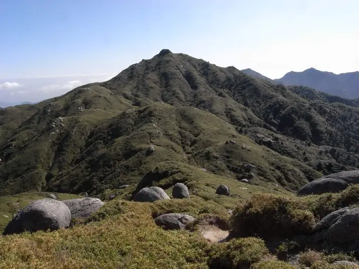
Mount Miyanoura is a 1,936 m peak in Yakushima Town, Kagoshima Prefecture, the highest summit on Yakushima Island and the highest mountain in the Kyushu region (including the mainland). It is also the highest peak in Kagoshima and is listed in Fukada Kyūya's Hyakumeizan and the Ittō-Sankakuten Hyakumeizan. As the centrepiece of Yakushima National Park, it lies within the core zone of the Yakushima World Heritage Site and is sometimes called the "Marine Alps" for its alpine character on an island in the open sea. Its summit ridges are dotted with weathered granite tors among Yakushi-zasa bamboo, and the slopes harbor the endemic Rhododendron yakushimanum and the Hananoego high-altitude wetlands. The standard route is the Ambō trail from the Yodogawa trailhead via Hananoego and Mount Kurio, often combined into a longer traverse linking Shiratani-Unsuikyō and the Jōmon-sugi cedar.
สรุป Mount Miyanoura
- อากาศ: วันที่อากาศคงที่ที่สุดใน 7 วันข้างหน้าคือ อาทิตย์ 8 พฤศจิกายน: ท้องฟ้าแจ่มใส ลมกระโชกสูงสุด 11 ม./วินาที ศุกร์ 6 พ.ย. ลมแรง (ลมกระโชกสูงสุด 17 ม./วินาที)
- เส้นทาง: เส้นทางที่สั้นที่สุดคือ Mount Miyanoura Traverse from Yodogawa Trailhead to Shiratani Unsuikyo: ประมาณ 15 ชม. 21 นาที 25.6 km ขึ้นประมาณ 1,730 m
อากาศ Mount Miyanoura (รายชั่วโมง 2 สัปดาห์)
วันนี้พระอาทิตย์ขึ้น 06:33 ตก 17:30
| อังคาร 3/11 | พุธ 4/11 | พฤหัส 5/11 | ศุกร์ 6/11 | เสาร์ 7/11 | อาทิตย์ 8/11 | จันทร์ 9/11 | อังคาร 10/11 | พุธ 11/11 | พฤหัส 12/11 | ศุกร์ 13/11 | เสาร์ 14/11 | อาทิตย์ 15/11 | จันทร์ 16/11 | อังคาร 17/11 | |||||||||||||||||||||||||||||||||||||||||||||||||||||||||||||||||||||||
|---|---|---|---|---|---|---|---|---|---|---|---|---|---|---|---|---|---|---|---|---|---|---|---|---|---|---|---|---|---|---|---|---|---|---|---|---|---|---|---|---|---|---|---|---|---|---|---|---|---|---|---|---|---|---|---|---|---|---|---|---|---|---|---|---|---|---|---|---|---|---|---|---|---|---|---|---|---|---|---|---|---|---|---|---|---|
| เวลาญี่ปุ่น | 21 | 23 | 1 | 3 | 5 | 7 | 9 | 11 | 13 | 15 | 17 | 19 | 21 | 0 | 3 | 6 | 9 | 12 | 15 | 18 | 21 | 0 | 3 | 6 | 9 | 12 | 15 | 18 | 21 | 0 | 3 | 6 | 9 | 12 | 15 | 18 | 21 | 0 | 3 | 6 | 9 | 12 | 15 | 18 | 21 | 0 | 3 | 6 | 9 | 12 | 15 | 21 | 3 | 9 | 15 | 21 | 3 | 9 | 15 | 21 | 3 | 9 | 15 | 21 | 3 | 9 | 15 | 21 | 3 | 9 | 15 | 21 | 3 | 9 | 15 | 21 | 3 | 9 | 15 | 21 | 3 | 9 | 15 | 21 | |
  | | |   | |   | | | | | | |   |   | |   |   |   | | | | | | | | |   | | | | |  |  | | | | | | | | | | | | | | | | | | | | |   | |   | | | | | | | | | | | | | | | | | | | | | |   | | | | | | | ||
| อุณหภูมิ | °C | 7° | 7° | 7° | 7° | 7° | 7° | 12° | 14° | 14° | 13° | 12° | 10° | 9° | 8° | 7° | 7° | 13° | 16° | 15° | 12° | 11° | 10° | 9° | 8° | 10° | 12° | 11° | 8° | 8° | 8° | 6° | 5° | 7° | 9° | 9° | 4° | 3° | 3° | 4° | 5° | 10° | 11° | 11° | 8° | 7° | 6° | 5° | 5° | 11° | 13° | 10° | 7° | 6° | 5° | 7° | 4° | 2° | 6° | 7° | 2° | 3° | 7° | 7° | 3° | 2° | 8° | 9° | 5° | 4° | 10° | 11° | 8° | 7° | 11° | 11° | 11° | 9° | 11° | 12° | 8° | 6° | 10° | 9° | 7° |
| ฝนและหิมะ | mm | 0.1 | 0.1 | 0.3 | 0.7 | 2.5 | 1.5 | 0.4 | 0.6 | 0.1 | 0.3 | 3.4 | 0.3 | 1.2 | 1.1 | 1.0 | 0.7 | 0.4 | 0.3 | 0.1 | 2.8 | 23 | 4.8 | 1.2 | 2.3 | 0.8 | 0.2 | 2.9 | 2.1 | ||||||||||||||||||||||||||||||||||||||||||||||||||||||||
| หิมะตก | cm | ||||||||||||||||||||||||||||||||||||||||||||||||||||||||||||||||||||||||||||||||||||
| หิมะสะสม | cm | 0 | 0 | 0 | 0 | 0 | 0 | 0 | 0 | 0 | 0 | 0 | 0 | 0 | 0 | 0 | 0 | 0 | 0 | 0 | 0 | 0 | 0 | 0 | 0 | 0 | 0 | 0 | 0 | 0 | 0 | 0 | 0 | 0 | 0 | 0 | 0 | 0 | 0 | 0 | 0 | 0 | 0 | 0 | 0 | 0 | 0 | 0 | 0 | 0 | 0 | 0 | 0 | 0 | 0 | 0 | 0 | 0 | 0 | 0 | 0 | 0 | 0 | 0 | 0 | 0 | 0 | 0 | 0 | 0 | 0 | 0 | 0 | 0 | 0 | 0 | 0 | 0 | 0 | 0 | 0 | 0 | 0 | 0 | 0 |
| ลม | m/s | 1 | 1 | 2 | 2 | 2 | 2 | 3 | 3 | 3 | 3 | 2 | 2 | 1 | 0 | 0 | 0 | 1 | 1 | 2 | 3 | 3 | 3 | 3 | 4 | 4 | 4 | 4 | 4 | 4 | 3 | 2 | 2 | 3 | 3 | 2 | 0 | 1 | 1 | 2 | 2 | 3 | 2 | 2 | 1 | 1 | 0 | 0 | 0 | 1 | 2 | 1 | 2 | 3 | 4 | 5 | 4 | 3 | 3 | 2 | 0 | 1 | 1 | 2 | 1 | 1 | 1 | 2 | 1 | 0 | 3 | 3 | 2 | 2 | 3 | 3 | 3 | 2 | 2 | 3 | 2 | 1 | 0 | 2 | 0 |
| ลมกระโชก | m/s | 6 | 6 | 6 | 8 | 8 | 9 | 11 | 11 | 11 | 11 | 10 | 8 | 8 | 7 | 5 | 4 | 6 | 9 | 12 | 13 | 13 | 13 | 14 | 14 | 15 | 15 | 17 | 17 | 16 | 15 | 13 | 13 | 13 | 13 | 11 | 8 | 4 | 6 | 8 | 9 | 10 | 11 | 8 | 7 | 5 | 5 | 3 | 4 | 4 | 6 | 7 | 8 | 11 | 14 | 18 | 17 | 16 | 14 | 12 | 8 | 4 | 5 | 8 | 8 | 6 | 5 | 8 | 8 | 6 | 9 | 12 | 10 | 10 | 14 | 15 | 19 | 19 | 12 | 12 | 10 | 6 | 6 | 7 | 7 |
| ทิศทางลม | ↓ | ↓ | ↓ | ↓ | ↓ | ↓ | ↓ | ↓ | ↓ | ↓ | ↓ | ↓ | ↓ | ↓ | ↓ | ↓ | ↓ | ↓ | ↓ | ↓ | ↓ | ↓ | ↓ | ↓ | ↓ | ↓ | ↓ | ↓ | ↓ | ↓ | ↓ | ↓ | ↓ | ↓ | ↓ | ↓ | ↓ | ↓ | ↓ | ↓ | ↓ | ↓ | ↓ | ↓ | ↓ | ↓ | ↓ | ↓ | ↓ | ↓ | ↓ | ↓ | ↓ | ↓ | ↓ | ↓ | ↓ | ↓ | ↓ | ↓ | ↓ | ↓ | ↓ | ↓ | ↓ | ↓ | ↓ | ↓ | ↓ | ↓ | ↓ | ↓ | ↓ | ↓ | ↓ | ↓ | ↓ | ↓ | ↓ | ↓ | ↓ | ↓ | ↓ | ↓ | |
เส้นทางเดินป่า Mount Miyanoura
เวลาเดินเป็นค่าประมาณที่คำนวณจากภูมิประเทศ
กระท่อม ที่ตั้งแคมป์ และที่พักใกล้ Mount Miyanoura
กระท่อมบนภูเขา
รายชื่อที่มี Mount Miyanoura
100 ภูเขาที่มีชื่อเสียงของญี่ปุ่น · 200 ภูเขาที่มีชื่อเสียงของญี่ปุ่น · 300 ภูเขาที่มีชื่อเสียงของญี่ปุ่น · 100 ภูเขาที่มีชื่อเสียงซึ่งมีหมุดสามเหลี่ยมชั้นหนึ่ง · ยอดเขาสูงที่สุดแยกตามจังหวัด · 100 ภูเขาที่มีชื่อเสียงของคิวชู · 100 ภูเขาบนเกาะที่คัดสรร · ระดับความสูงของภูเขา 1003 แห่งในญี่ปุ่น · ภูเขา 1000 แห่งของญี่ปุ่น
ข้อมูลพื้นฐาน Mount Miyanoura
- ชื่ออื่น
- 奥岳
- ความสูง
- 1,936 ม.
- ที่ตั้ง
- ยากูชิมะ, คาโงชิมะ
30.336116, 130.504205 - อุทยานแห่งชาติ
- 屋久島国立公園
- เว็บไซต์
- www.town.yakushima.kagoshima.jp
- แผนที่เส้นทางเดินเขา
- www.env.go.jp
- วิกิพีเดีย
- ja.wikipedia.org