
Kuriodake
栗生岳
Yakushima, Kagoshima · Elevation 1,863 m
Kuriodake is a 1,863 m summit in central Yakushima, in Yakushima Town, Kagoshima Prefecture, just before Miyanouradake (1,936 m), the highest peak in Kyushu. The route to Miyanouradake from the Yodogawa trailhead is about 14 km and takes 10–11 hours. Kuriodake is a 15-minute walk from the Okina junction and a further 20 minutes from Miyanouradake. It lies in Yakushima National Park.
Kuriodake at a glance
- Weather: The most settled day in the next 7 days is Sun, November 8: cloudy, gusts up to 9 m/s. Fri, Nov 6: strong wind (gusts up to 16 m/s).
- Route: The shortest is Mount Miyanoura Traverse from Yodogawa Trailhead to Shiratani Unsuikyo: about 15 h 21 min, 25.6 km, about 1,730 m of climbing.
Kuriodake weather (hourly, 14 days)
Sunrise today 06:33, sunset 17:30
| Tue, 11/3 | Wed, 11/4 | Thu, 11/5 | Fri, 11/6 | Sat, 11/7 | Sun, 11/8 | Mon, 11/9 | Tue, 11/10 | Wed, 11/11 | Thu, 11/12 | Fri, 11/13 | Sat, 11/14 | Sun, 11/15 | Mon, 11/16 | Tue, 11/17 | |||||||||||||||||||||||||||||||||||||||||||||||||||||||||||||||||||||||
|---|---|---|---|---|---|---|---|---|---|---|---|---|---|---|---|---|---|---|---|---|---|---|---|---|---|---|---|---|---|---|---|---|---|---|---|---|---|---|---|---|---|---|---|---|---|---|---|---|---|---|---|---|---|---|---|---|---|---|---|---|---|---|---|---|---|---|---|---|---|---|---|---|---|---|---|---|---|---|---|---|---|---|---|---|---|
| Japan time | 15 | 17 | 19 | 21 | 23 | 1 | 3 | 5 | 7 | 9 | 11 | 13 | 15 | 18 | 21 | 0 | 3 | 6 | 9 | 12 | 15 | 18 | 21 | 0 | 3 | 6 | 9 | 12 | 15 | 18 | 21 | 0 | 3 | 6 | 9 | 12 | 15 | 18 | 21 | 0 | 3 | 6 | 9 | 12 | 15 | 18 | 21 | 0 | 3 | 6 | 9 | 15 | 21 | 3 | 9 | 15 | 21 | 3 | 9 | 15 | 21 | 3 | 9 | 15 | 21 | 3 | 9 | 15 | 21 | 3 | 9 | 15 | 21 | 3 | 9 | 15 | 21 | 3 | 9 | 15 | 21 | 3 | 9 | 15 | |
  |   |   | | | | |   |   |   | | | | | |   |   | | | | |   | | | | |   |  |   | | |  | | | | | | | | | | | | | | |   | | | | | | | | | | | | | | | | | | | | | | | | | | | | | | | | | | | | | | ||
| Temperature | °C | 11° | 10° | 8° | 8° | 8° | 8° | 8° | 8° | 8° | 12° | 14° | 15° | 14° | 10° | 10° | 9° | 8° | 8° | 13° | 16° | 15° | 12° | 12° | 12° | 11° | 10° | 11° | 13° | 12° | 9° | 9° | 6° | 4° | 3° | 7° | 9° | 9° | 4° | 3° | 2° | 4° | 4° | 10° | 12° | 12° | 8° | 7° | 7° | 6° | 7° | 11° | 10° | 8° | 6° | 6° | 8° | 4° | 3° | 6° | 8° | 3° | 3° | 7° | 8° | 4° | 3° | 8° | 10° | 6° | 4° | 10° | 12° | 8° | 8° | 11° | 11° | 12° | 10° | 11° | 13° | 8° | 6° | 11° | 10° |
| Precipitation | mm | 1.0 | 0.1 | 0.2 | 0.1 | 0.5 | 1.0 | 1.9 | 1.6 | 1.0 | 1.1 | 0.4 | 3.5 | 0.3 | 1.2 | 1.1 | 1.0 | 0.7 | 0.4 | 0.3 | 0.1 | 2.8 | 23 | 4.8 | 1.2 | 2.3 | 0.8 | 0.2 | 2.9 | ||||||||||||||||||||||||||||||||||||||||||||||||||||||||
| New snow | cm | ||||||||||||||||||||||||||||||||||||||||||||||||||||||||||||||||||||||||||||||||||||
| Snow depth | cm | 0 | 0 | 0 | 0 | 0 | 0 | 0 | 0 | 0 | 0 | 0 | 0 | 0 | 0 | 0 | 0 | 0 | 0 | 0 | 0 | 0 | 0 | 0 | 0 | 0 | 0 | 0 | 0 | 0 | 0 | 0 | 0 | 0 | 0 | 0 | 0 | 0 | 0 | 0 | 0 | 0 | 0 | 0 | 0 | 0 | 0 | 0 | 0 | 0 | 0 | 0 | 0 | 0 | 0 | 0 | 0 | 0 | 0 | 0 | 0 | 0 | 0 | 0 | 0 | 0 | 0 | 0 | 0 | 0 | 0 | 0 | 0 | 0 | 0 | 0 | 0 | 0 | 0 | 0 | 0 | 0 | 0 | 0 | 0 |
| Wind | m/s | 2 | 2 | 1 | 1 | 1 | 2 | 2 | 2 | 1 | 3 | 3 | 3 | 3 | 2 | 1 | 1 | 0 | 0 | 0 | 1 | 2 | 1 | 2 | 3 | 3 | 3 | 3 | 4 | 4 | 4 | 4 | 3 | 2 | 2 | 3 | 3 | 2 | 1 | 0 | 0 | 2 | 1 | 3 | 2 | 2 | 1 | 0 | 0 | 0 | 0 | 2 | 2 | 2 | 3 | 4 | 5 | 4 | 3 | 3 | 2 | 0 | 1 | 1 | 2 | 1 | 1 | 1 | 2 | 1 | 0 | 3 | 3 | 2 | 2 | 3 | 3 | 3 | 2 | 2 | 3 | 2 | 1 | 0 | 2 |
| Wind gusts | m/s | 8 | 8 | 7 | 7 | 7 | 7 | 8 | 8 | 9 | 10 | 11 | 11 | 11 | 10 | 8 | 8 | 5 | 3 | 5 | 9 | 10 | 11 | 10 | 11 | 12 | 13 | 14 | 14 | 16 | 17 | 16 | 15 | 14 | 13 | 13 | 13 | 11 | 9 | 4 | 3 | 6 | 7 | 9 | 9 | 7 | 7 | 4 | 4 | 4 | 4 | 6 | 7 | 8 | 11 | 14 | 18 | 17 | 16 | 14 | 12 | 8 | 4 | 5 | 8 | 8 | 6 | 5 | 8 | 8 | 6 | 9 | 12 | 10 | 10 | 14 | 15 | 19 | 19 | 12 | 12 | 10 | 6 | 6 | 7 |
| Wind dir. | ↓ | ↓ | ↓ | ↓ | ↓ | ↓ | ↓ | ↓ | ↓ | ↓ | ↓ | ↓ | ↓ | ↓ | ↓ | ↓ | ↓ | ↓ | ↓ | ↓ | ↓ | ↓ | ↓ | ↓ | ↓ | ↓ | ↓ | ↓ | ↓ | ↓ | ↓ | ↓ | ↓ | ↓ | ↓ | ↓ | ↓ | ↓ | ↓ | ↓ | ↓ | ↓ | ↓ | ↓ | ↓ | ↓ | ↓ | ↓ | ↓ | ↓ | ↓ | ↓ | ↓ | ↓ | ↓ | ↓ | ↓ | ↓ | ↓ | ↓ | ↓ | ↓ | ↓ | ↓ | ↓ | ↓ | ↓ | ↓ | ↓ | ↓ | ↓ | ↓ | ↓ | ↓ | ↓ | ↓ | ↓ | ↓ | ↓ | ↓ | ↓ | ↓ | ↓ | ↓ | |
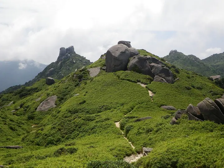
Kuriodake hiking routes
Hiking times are estimates calculated from the terrain.
Huts, campsites and lodging near Kuriodake
Mountain huts
Kuriodake facts
- Elevation
- 1,863 m
- Location
- Yakushima, Kagoshima
30.333546, 130.507005 - National Park
- 屋久島国立公園
- Website
- yakukan.jp