
Tachūdake
太忠岳
Yakushima, Kagoshima · Elevation 1,497 m
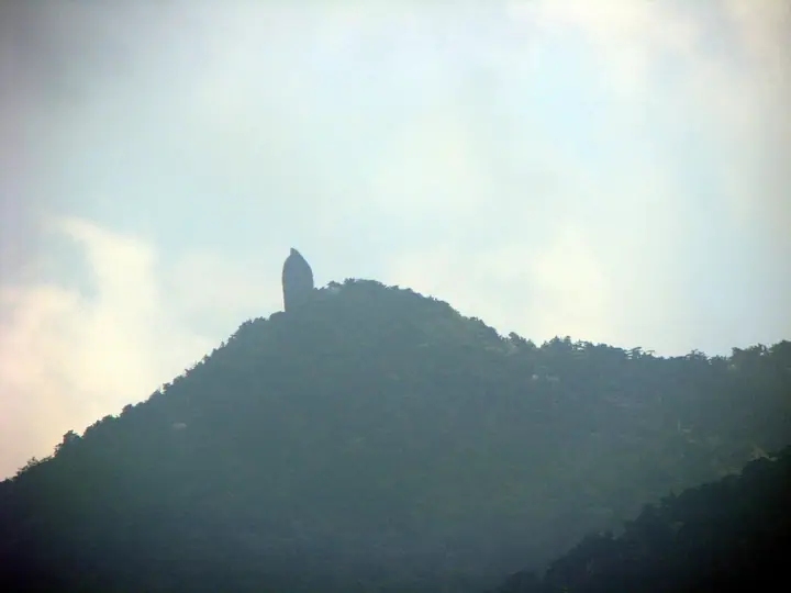
Tachudake is a 1,497 m mountain in Anbo, Yakushima Town, Kagoshima Prefecture. A single 40-metre slab of granite called Tenchuseki stands on its summit, thrusting up like a thumb raised to the sky and visible from the village of Anbo. A small shrine shelters under the rock, and the mountain is one of those visited on the island's takemairi pilgrimages. The climb branches off the 150-minute circuit in Yakusugi Land at the fallen Jamon-sugi and passes through the forests of Obanayama and Tenmon. The round trip is about 7 km, six to seven hours, with 497 m of ascent. It lies in Yakushima National Park, within the World Natural Heritage area.
Tachūdake at a glance
- Weather: The most settled day in the next 7 days is Sun, November 8: cloudy, gusts up to 9 m/s. Fri, Nov 6: strong wind (gusts up to 16 m/s).
- Route: The shortest is Mount Tachu Return from Yakusugi Land: about 4 h 45 min, 7.4 km, about 700 m of climbing.
Tachūdake weather (hourly, 14 days)
Sunrise today 06:33, sunset 17:30
| Tue, 11/3 | Wed, 11/4 | Thu, 11/5 | Fri, 11/6 | Sat, 11/7 | Sun, 11/8 | Mon, 11/9 | Tue, 11/10 | Wed, 11/11 | Thu, 11/12 | Fri, 11/13 | Sat, 11/14 | Sun, 11/15 | Mon, 11/16 | Tue, 11/17 | |||||||||||||||||||||||||||||||||||||||||||||||||||||||||||||||||||||||
|---|---|---|---|---|---|---|---|---|---|---|---|---|---|---|---|---|---|---|---|---|---|---|---|---|---|---|---|---|---|---|---|---|---|---|---|---|---|---|---|---|---|---|---|---|---|---|---|---|---|---|---|---|---|---|---|---|---|---|---|---|---|---|---|---|---|---|---|---|---|---|---|---|---|---|---|---|---|---|---|---|---|---|---|---|---|
| Japan time | 15 | 17 | 19 | 21 | 23 | 1 | 3 | 5 | 7 | 9 | 11 | 13 | 15 | 18 | 21 | 0 | 3 | 6 | 9 | 12 | 15 | 18 | 21 | 0 | 3 | 6 | 9 | 12 | 15 | 18 | 21 | 0 | 3 | 6 | 9 | 12 | 15 | 18 | 21 | 0 | 3 | 6 | 9 | 12 | 15 | 18 | 21 | 0 | 3 | 6 | 9 | 15 | 21 | 3 | 9 | 15 | 21 | 3 | 9 | 15 | 21 | 3 | 9 | 15 | 21 | 3 | 9 | 15 | 21 | 3 | 9 | 15 | 21 | 3 | 9 | 15 | 21 | 3 | 9 | 15 | 21 | 3 | 9 | 15 | |
  |   |   | | | | |   |   |   | | | | | |   |   | | | | |   | | | | |   |  |   | | |  | | | | | | | | | | | | | | |   | | | | | | | | | | | | | | | | | | | | | | | | | | | | | | | | | | | | | | ||
| Temperature | °C | 14° | 13° | 10° | 10° | 10° | 10° | 10° | 11° | 10° | 14° | 17° | 17° | 16° | 13° | 12° | 11° | 11° | 10° | 15° | 19° | 17° | 14° | 14° | 14° | 13° | 13° | 13° | 15° | 14° | 12° | 11° | 8° | 7° | 6° | 9° | 11° | 11° | 6° | 5° | 5° | 6° | 6° | 12° | 14° | 14° | 10° | 9° | 9° | 8° | 9° | 13° | 13° | 10° | 8° | 8° | 10° | 7° | 5° | 8° | 10° | 5° | 5° | 10° | 10° | 6° | 5° | 11° | 12° | 8° | 7° | 13° | 14° | 11° | 10° | 14° | 14° | 14° | 12° | 13° | 15° | 11° | 8° | 13° | 12° |
| Precipitation | mm | 1.0 | 0.1 | 0.2 | 0.1 | 0.5 | 1.0 | 1.9 | 1.6 | 1.0 | 1.1 | 0.4 | 3.5 | 0.3 | 1.2 | 1.1 | 1.0 | 0.7 | 0.4 | 0.3 | 0.1 | 2.8 | 23 | 4.8 | 1.2 | 2.3 | 0.8 | 0.2 | 2.9 | ||||||||||||||||||||||||||||||||||||||||||||||||||||||||
| New snow | cm | ||||||||||||||||||||||||||||||||||||||||||||||||||||||||||||||||||||||||||||||||||||
| Snow depth | cm | 0 | 0 | 0 | 0 | 0 | 0 | 0 | 0 | 0 | 0 | 0 | 0 | 0 | 0 | 0 | 0 | 0 | 0 | 0 | 0 | 0 | 0 | 0 | 0 | 0 | 0 | 0 | 0 | 0 | 0 | 0 | 0 | 0 | 0 | 0 | 0 | 0 | 0 | 0 | 0 | 0 | 0 | 0 | 0 | 0 | 0 | 0 | 0 | 0 | 0 | 0 | 0 | 0 | 0 | 0 | 0 | 0 | 0 | 0 | 0 | 0 | 0 | 0 | 0 | 0 | 0 | 0 | 0 | 0 | 0 | 0 | 0 | 0 | 0 | 0 | 0 | 0 | 0 | 0 | 0 | 0 | 0 | 0 | 0 |
| Wind | m/s | 2 | 2 | 1 | 1 | 1 | 2 | 2 | 2 | 1 | 3 | 3 | 3 | 3 | 2 | 1 | 1 | 0 | 0 | 0 | 1 | 2 | 1 | 2 | 3 | 3 | 3 | 3 | 4 | 4 | 4 | 4 | 3 | 2 | 2 | 3 | 3 | 2 | 1 | 0 | 0 | 2 | 1 | 3 | 2 | 2 | 1 | 0 | 0 | 0 | 0 | 2 | 2 | 2 | 3 | 4 | 5 | 4 | 3 | 3 | 2 | 0 | 1 | 1 | 2 | 1 | 1 | 1 | 2 | 1 | 0 | 3 | 3 | 2 | 2 | 3 | 3 | 3 | 2 | 2 | 3 | 2 | 1 | 0 | 2 |
| Wind gusts | m/s | 8 | 8 | 7 | 7 | 7 | 7 | 8 | 8 | 9 | 10 | 11 | 11 | 11 | 10 | 8 | 8 | 5 | 3 | 5 | 9 | 10 | 11 | 10 | 11 | 12 | 13 | 14 | 14 | 16 | 17 | 16 | 15 | 14 | 13 | 13 | 13 | 11 | 9 | 4 | 3 | 6 | 7 | 9 | 9 | 7 | 7 | 4 | 4 | 4 | 4 | 6 | 7 | 8 | 11 | 14 | 18 | 17 | 16 | 14 | 12 | 8 | 4 | 5 | 8 | 8 | 6 | 5 | 8 | 8 | 6 | 9 | 12 | 10 | 10 | 14 | 15 | 19 | 19 | 12 | 12 | 10 | 6 | 6 | 7 |
| Wind dir. | ↓ | ↓ | ↓ | ↓ | ↓ | ↓ | ↓ | ↓ | ↓ | ↓ | ↓ | ↓ | ↓ | ↓ | ↓ | ↓ | ↓ | ↓ | ↓ | ↓ | ↓ | ↓ | ↓ | ↓ | ↓ | ↓ | ↓ | ↓ | ↓ | ↓ | ↓ | ↓ | ↓ | ↓ | ↓ | ↓ | ↓ | ↓ | ↓ | ↓ | ↓ | ↓ | ↓ | ↓ | ↓ | ↓ | ↓ | ↓ | ↓ | ↓ | ↓ | ↓ | ↓ | ↓ | ↓ | ↓ | ↓ | ↓ | ↓ | ↓ | ↓ | ↓ | ↓ | ↓ | ↓ | ↓ | ↓ | ↓ | ↓ | ↓ | ↓ | ↓ | ↓ | ↓ | ↓ | ↓ | ↓ | ↓ | ↓ | ↓ | ↓ | ↓ | ↓ | ↓ | |
Tachūdake hiking routes
Hiking times are estimates calculated from the terrain.
Huts, campsites and lodging near Tachūdake
Mountain huts
Tachūdake facts
- Elevation
- 1,497 m
- Location
- Yakushima, Kagoshima
30.319660, 130.563401 - National Park
- 屋久島国立公園
- Website
- yakukan.jp