
Mount Kuromi
黒味岳
Yakushima, Kagoshima · Elevation 1,831 m
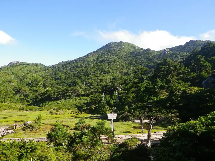
Mount Kuromi (1,831 m) rises south of Mount Miyanoura in Yakushima Town, Kagoshima Prefecture, and is Kyūshū's sixth-highest peak. Within Yakushima National Park and the World Heritage Site, it is one of the few high summits on the island that can be done as a day hike from the Yodogawa trailhead. Massive granite boulders crown the top, opening up sweeping views of Miyanoura, Nagata, and the southern Kyūshū ranges; Yakushima rhododendrons and dwarf alpine flora bloom from mid-May into early June. It is listed in the Kyūshū Hyakumeizan.
Mount Kuromi at a glance
- Weather: The most settled day in the next 7 days is Sun, November 8: cloudy, gusts up to 9 m/s. Fri, Nov 6: strong wind (gusts up to 16 m/s).
- Route: The shortest is Mount Miyanoura Traverse from Yodogawa Trailhead to Shiratani Unsuikyo: about 15 h 21 min, 25.6 km, about 1,730 m of climbing.
Mount Kuromi weather (hourly, 14 days)
Sunrise today 06:33, sunset 17:30
| Tue, 11/3 | Wed, 11/4 | Thu, 11/5 | Fri, 11/6 | Sat, 11/7 | Sun, 11/8 | Mon, 11/9 | Tue, 11/10 | Wed, 11/11 | Thu, 11/12 | Fri, 11/13 | Sat, 11/14 | Sun, 11/15 | Mon, 11/16 | Tue, 11/17 | |||||||||||||||||||||||||||||||||||||||||||||||||||||||||||||||||||||||
|---|---|---|---|---|---|---|---|---|---|---|---|---|---|---|---|---|---|---|---|---|---|---|---|---|---|---|---|---|---|---|---|---|---|---|---|---|---|---|---|---|---|---|---|---|---|---|---|---|---|---|---|---|---|---|---|---|---|---|---|---|---|---|---|---|---|---|---|---|---|---|---|---|---|---|---|---|---|---|---|---|---|---|---|---|---|
| Japan time | 15 | 17 | 19 | 21 | 23 | 1 | 3 | 5 | 7 | 9 | 11 | 13 | 15 | 18 | 21 | 0 | 3 | 6 | 9 | 12 | 15 | 18 | 21 | 0 | 3 | 6 | 9 | 12 | 15 | 18 | 21 | 0 | 3 | 6 | 9 | 12 | 15 | 18 | 21 | 0 | 3 | 6 | 9 | 12 | 15 | 18 | 21 | 0 | 3 | 6 | 9 | 15 | 21 | 3 | 9 | 15 | 21 | 3 | 9 | 15 | 21 | 3 | 9 | 15 | 21 | 3 | 9 | 15 | 21 | 3 | 9 | 15 | 21 | 3 | 9 | 15 | 21 | 3 | 9 | 15 | 21 | 3 | 9 | 15 | |
  |   |   | | | | |   |   |   | | | | | |   |   | | | | |   | | | | |   |  |   | | |  | | | | | | | | | | | | | | |   | | | | | | | | | | | | | | | | | | | | | | | | | | | | | | | | | | | | | | ||
| Temperature | °C | 12° | 10° | 8° | 8° | 8° | 8° | 8° | 8° | 8° | 12° | 14° | 15° | 14° | 11° | 10° | 9° | 8° | 8° | 13° | 17° | 15° | 12° | 12° | 12° | 11° | 10° | 11° | 13° | 12° | 9° | 9° | 6° | 4° | 3° | 7° | 9° | 9° | 4° | 3° | 3° | 4° | 4° | 10° | 12° | 12° | 8° | 7° | 7° | 6° | 7° | 11° | 10° | 8° | 6° | 6° | 8° | 5° | 3° | 6° | 8° | 3° | 3° | 7° | 8° | 4° | 3° | 8° | 10° | 6° | 5° | 11° | 12° | 8° | 8° | 11° | 11° | 12° | 10° | 11° | 13° | 8° | 6° | 11° | 10° |
| Precipitation | mm | 1.0 | 0.1 | 0.2 | 0.1 | 0.5 | 1.0 | 1.9 | 1.6 | 1.0 | 1.1 | 0.4 | 3.5 | 0.3 | 1.2 | 1.1 | 1.0 | 0.7 | 0.4 | 0.3 | 0.1 | 2.8 | 23 | 4.8 | 1.2 | 2.3 | 0.8 | 0.2 | 2.9 | ||||||||||||||||||||||||||||||||||||||||||||||||||||||||
| New snow | cm | ||||||||||||||||||||||||||||||||||||||||||||||||||||||||||||||||||||||||||||||||||||
| Snow depth | cm | 0 | 0 | 0 | 0 | 0 | 0 | 0 | 0 | 0 | 0 | 0 | 0 | 0 | 0 | 0 | 0 | 0 | 0 | 0 | 0 | 0 | 0 | 0 | 0 | 0 | 0 | 0 | 0 | 0 | 0 | 0 | 0 | 0 | 0 | 0 | 0 | 0 | 0 | 0 | 0 | 0 | 0 | 0 | 0 | 0 | 0 | 0 | 0 | 0 | 0 | 0 | 0 | 0 | 0 | 0 | 0 | 0 | 0 | 0 | 0 | 0 | 0 | 0 | 0 | 0 | 0 | 0 | 0 | 0 | 0 | 0 | 0 | 0 | 0 | 0 | 0 | 0 | 0 | 0 | 0 | 0 | 0 | 0 | 0 |
| Wind | m/s | 2 | 2 | 1 | 1 | 1 | 2 | 2 | 2 | 1 | 3 | 3 | 3 | 3 | 2 | 1 | 1 | 0 | 0 | 0 | 1 | 2 | 1 | 2 | 3 | 3 | 3 | 3 | 4 | 4 | 4 | 4 | 3 | 2 | 2 | 3 | 3 | 2 | 1 | 0 | 0 | 2 | 1 | 3 | 2 | 2 | 1 | 0 | 0 | 0 | 0 | 2 | 2 | 2 | 3 | 4 | 5 | 4 | 3 | 3 | 2 | 0 | 1 | 1 | 2 | 1 | 1 | 1 | 2 | 1 | 0 | 3 | 3 | 2 | 2 | 3 | 3 | 3 | 2 | 2 | 3 | 2 | 1 | 0 | 2 |
| Wind gusts | m/s | 8 | 8 | 7 | 7 | 7 | 7 | 8 | 8 | 9 | 10 | 11 | 11 | 11 | 10 | 8 | 8 | 5 | 3 | 5 | 9 | 10 | 11 | 10 | 11 | 12 | 13 | 14 | 14 | 16 | 17 | 16 | 15 | 14 | 13 | 13 | 13 | 11 | 9 | 4 | 3 | 6 | 7 | 9 | 9 | 7 | 7 | 4 | 4 | 4 | 4 | 6 | 7 | 8 | 11 | 14 | 18 | 17 | 16 | 14 | 12 | 8 | 4 | 5 | 8 | 8 | 6 | 5 | 8 | 8 | 6 | 9 | 12 | 10 | 10 | 14 | 15 | 19 | 19 | 12 | 12 | 10 | 6 | 6 | 7 |
| Wind dir. | ↓ | ↓ | ↓ | ↓ | ↓ | ↓ | ↓ | ↓ | ↓ | ↓ | ↓ | ↓ | ↓ | ↓ | ↓ | ↓ | ↓ | ↓ | ↓ | ↓ | ↓ | ↓ | ↓ | ↓ | ↓ | ↓ | ↓ | ↓ | ↓ | ↓ | ↓ | ↓ | ↓ | ↓ | ↓ | ↓ | ↓ | ↓ | ↓ | ↓ | ↓ | ↓ | ↓ | ↓ | ↓ | ↓ | ↓ | ↓ | ↓ | ↓ | ↓ | ↓ | ↓ | ↓ | ↓ | ↓ | ↓ | ↓ | ↓ | ↓ | ↓ | ↓ | ↓ | ↓ | ↓ | ↓ | ↓ | ↓ | ↓ | ↓ | ↓ | ↓ | ↓ | ↓ | ↓ | ↓ | ↓ | ↓ | ↓ | ↓ | ↓ | ↓ | ↓ | ↓ | |
Mount Kuromi hiking routes
Hiking times are estimates calculated from the terrain.
Huts, campsites and lodging near Mount Kuromi
Mountain huts
Lists that include Mount Kuromi
Mount Kuromi facts
- Also known as
- 奥岳
- Elevation
- 1,831 m
- Location
- Yakushima, Kagoshima
30.317419, 130.508550 - National Park
- 屋久島国立公園
- Website
- yakukan.jp
- Trail Map
- yakukan.jp (PDF)