
Mount Mocchom
モッチョム岳
Yakushima, Kagoshima · Elevation 940 m
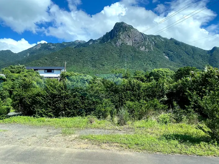
Mount Mocchom (also written 本富岳) is a 940 m granite spire in southern Yakushima, Yakushima Town, Kagoshima. Its needle-sharp silhouette has earned it the nickname "Matterhorn of the East," and its trail climbs through Yakushima National Park and the World Heritage core area on relentlessly steep gradients. Highlights along the way include the millennia-old Bandai-sugi and Mocchom-tarō Yakusugi cedars and the island's celebrated vertical zonation of vegetation; from the summit, hikers see the Pacific Ocean and the villages of southern Yakushima. Climbers are asked to contribute to the World Natural Heritage Yakushima Mountain Conservation Cooperation Fund (¥1,000 day hike, ¥2,000 overnight).
Mount Mocchom at a glance
- Weather: The most settled day in the next 7 days is Fri, November 6: clear, gusts up to 8 m/s.
- Route: The shortest is Mount Mocchomu from Senpiro Falls: about 4 h 6 min, 5.4 km, about 840 m of climbing.
Mount Mocchom weather (hourly, 14 days)
Sunrise today 06:33, sunset 17:30
| Tue, 11/3 | Wed, 11/4 | Thu, 11/5 | Fri, 11/6 | Sat, 11/7 | Sun, 11/8 | Mon, 11/9 | Tue, 11/10 | Wed, 11/11 | Thu, 11/12 | Fri, 11/13 | Sat, 11/14 | Sun, 11/15 | Mon, 11/16 | Tue, 11/17 | |||||||||||||||||||||||||||||||||||||||||||||||||||||||||||||||||||||||
|---|---|---|---|---|---|---|---|---|---|---|---|---|---|---|---|---|---|---|---|---|---|---|---|---|---|---|---|---|---|---|---|---|---|---|---|---|---|---|---|---|---|---|---|---|---|---|---|---|---|---|---|---|---|---|---|---|---|---|---|---|---|---|---|---|---|---|---|---|---|---|---|---|---|---|---|---|---|---|---|---|---|---|---|---|---|
| Japan time | 15 | 17 | 19 | 21 | 23 | 1 | 3 | 5 | 7 | 9 | 11 | 13 | 15 | 18 | 21 | 0 | 3 | 6 | 9 | 12 | 15 | 18 | 21 | 0 | 3 | 6 | 9 | 12 | 15 | 18 | 21 | 0 | 3 | 6 | 9 | 12 | 15 | 18 | 21 | 0 | 3 | 6 | 9 | 12 | 15 | 18 | 21 | 0 | 3 | 6 | 9 | 15 | 21 | 3 | 9 | 15 | 21 | 3 | 9 | 15 | 21 | 3 | 9 | 15 | 21 | 3 | 9 | 15 | 21 | 3 | 9 | 15 | 21 | 3 | 9 | 15 | 21 | 3 | 9 | 15 | 21 | 3 | 9 | 15 | |
  | |   | | | | | |   | | | | |   | | | |   | | |   |   | | | | | |  | | | |  | | | | | | | | | | | | |   | | | | | | | |   | |   | |   | | | | | | | | | | |   | | | | | | | | |   | | | | | | | | ||
| Temperature | °C | 16° | 15° | 13° | 13° | 13° | 13° | 13° | 13° | 13° | 16° | 18° | 18° | 18° | 15° | 15° | 14° | 13° | 13° | 18° | 20° | 19° | 17° | 16° | 16° | 16° | 15° | 16° | 18° | 17° | 14° | 14° | 11° | 10° | 9° | 12° | 15° | 14° | 10° | 8° | 8° | 9° | 10° | 14° | 16° | 16° | 13° | 13° | 12° | 11° | 12° | 15° | 14° | 13° | 11° | 11° | 13° | 9° | 7° | 11° | 13° | 8° | 9° | 12° | 12° | 9° | 9° | 13° | 14° | 11° | 10° | 15° | 16° | 14° | 14° | 15° | 16° | 17° | 15° | 16° | 18° | 13° | 12° | 14° | 15° |
| Precipitation | mm | 1.1 | 0.2 | 0.6 | 0.4 | 0.3 | 0.1 | 6 | 2.7 | 2.0 | 1.0 | 0.8 | 0.6 | 0.1 | 0.2 | 0.2 | 1.0 | 5 | 36 | 11 | 0.2 | 0.3 | 0.3 | 1.2 | 1.5 | 3.4 | |||||||||||||||||||||||||||||||||||||||||||||||||||||||||||
| New snow | cm | ||||||||||||||||||||||||||||||||||||||||||||||||||||||||||||||||||||||||||||||||||||
| Snow depth | cm | 0 | 0 | 0 | 0 | 0 | 0 | 0 | 0 | 0 | 0 | 0 | 0 | 0 | 0 | 0 | 0 | 0 | 0 | 0 | 0 | 0 | 0 | 0 | 0 | 0 | 0 | 0 | 0 | 0 | 0 | 0 | 0 | 0 | 0 | 0 | 0 | 0 | 0 | 0 | 0 | 0 | 0 | 0 | 0 | 0 | 0 | 0 | 0 | 0 | 0 | 0 | 0 | 0 | 0 | 0 | 0 | 0 | 0 | 0 | 0 | 0 | 0 | 0 | 0 | 0 | 0 | 0 | 0 | 0 | 0 | 0 | 0 | 0 | 0 | 0 | 0 | 0 | 0 | 0 | 0 | 0 | 0 | 0 | 0 |
| Wind | m/s | 2 | 2 | 2 | 2 | 3 | 3 | 3 | 3 | 2 | 4 | 5 | 4 | 4 | 3 | 3 | 2 | 1 | 0 | 1 | 3 | 4 | 3 | 2 | 2 | 1 | 1 | 2 | 1 | 2 | 2 | 2 | 2 | 2 | 3 | 3 | 1 | 1 | 0 | 2 | 2 | 3 | 3 | 4 | 3 | 3 | 2 | 1 | 2 | 1 | 1 | 1 | 1 | 1 | 2 | 2 | 3 | 2 | 2 | 1 | 1 | 1 | 1 | 0 | 0 | 0 | 1 | 1 | 2 | 2 | 2 | 4 | 4 | 3 | 4 | 5 | 5 | 5 | 3 | 1 | 0 | 0 | 0 | 0 | 1 |
| Wind gusts | m/s | 8 | 8 | 7 | 7 | 7 | 8 | 8 | 8 | 8 | 11 | 12 | 13 | 11 | 12 | 9 | 8 | 6 | 4 | 5 | 10 | 12 | 12 | 10 | 8 | 8 | 7 | 7 | 7 | 8 | 9 | 9 | 8 | 9 | 9 | 9 | 8 | 6 | 4 | 5 | 6 | 7 | 8 | 9 | 10 | 8 | 8 | 5 | 5 | 5 | 5 | 5 | 6 | 5 | 8 | 9 | 10 | 10 | 10 | 8 | 7 | 5 | 4 | 4 | 9 | 5 | 4 | 5 | 8 | 8 | 7 | 10 | 12 | 11 | 9 | 13 | 15 | 18 | 17 | 10 | 6 | 5 | 4 | 5 | 7 |
| Wind dir. | ↓ | ↓ | ↓ | ↓ | ↓ | ↓ | ↓ | ↓ | ↓ | ↓ | ↓ | ↓ | ↓ | ↓ | ↓ | ↓ | ↓ | ↓ | ↓ | ↓ | ↓ | ↓ | ↓ | ↓ | ↓ | ↓ | ↓ | ↓ | ↓ | ↓ | ↓ | ↓ | ↓ | ↓ | ↓ | ↓ | ↓ | ↓ | ↓ | ↓ | ↓ | ↓ | ↓ | ↓ | ↓ | ↓ | ↓ | ↓ | ↓ | ↓ | ↓ | ↓ | ↓ | ↓ | ↓ | ↓ | ↓ | ↓ | ↓ | ↓ | ↓ | ↓ | ↓ | ↓ | ↓ | ↓ | ↓ | ↓ | ↓ | ↓ | ↓ | ↓ | ↓ | ↓ | ↓ | ↓ | ↓ | ↓ | ↓ | ↓ | ↓ | ↓ | ↓ | ↓ | |
Mount Mocchom hiking routes
Hiking times are estimates calculated from the terrain.
Huts, campsites and lodging near Mount Mocchom
Campsites
- Jerry's camp site
Lodging
- Shikinoyado (minshuku)
- Shiki Noyado Onoaida
- 嵐の散歩道<屋久島>
- Yakushima Iwasaki Hotel
- samana hotel Yakushima
Lists that include Mount Mocchom
Kyushu 100 Famous Mountains · Elevations of 1003 Mountains of Japan · 1000 Mountains of Japan
Mount Mocchom facts
- Also known as
- 本富岳
- Elevation
- 940 m
- Location
- Yakushima, Kagoshima
30.256662, 130.564168 - National Park
- 屋久島国立公園
- Website
- www.town.yakushima.kagoshima.jp
- Trail Map
- www.town.yakushima.kagoshima.jp (PDF)
- Wikipedia
- ja.wikipedia.org