
Mount Nagata
永田岳
Yakushima, Kagoshima · Elevation 1,886 m
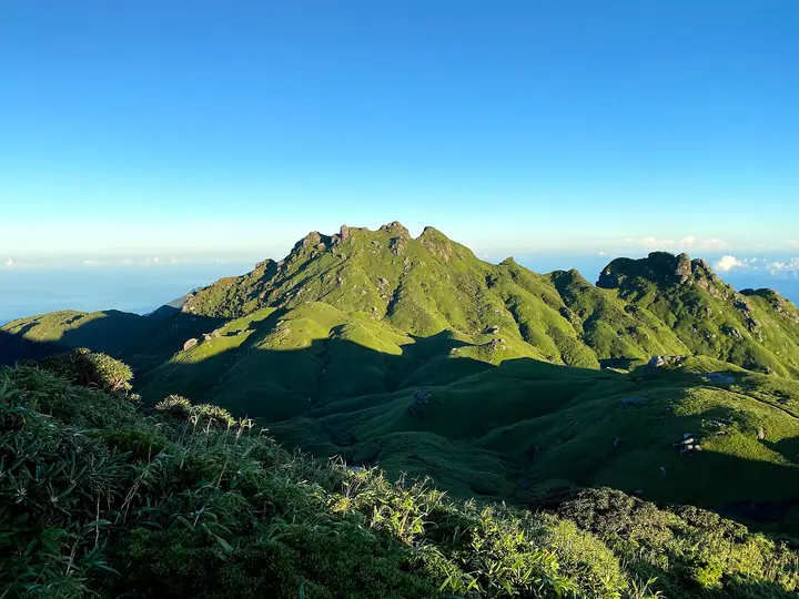
Mount Nagata (1,886 m) rises in Yakushima Town, Kagoshima Prefecture, about 2 km northwest of Mount Miyanoura, as the second-highest summit on Yakushima and in Kyūshū. Within Yakushima National Park — a World Natural Heritage Site — its rugged granite walls drop sharply westward toward the headwaters of the Nagata River. The peak has been a destination of takemairi pilgrimages by villagers from Nagata for centuries, and a small shrine still shelters under a rock outcrop near the top. It is listed in the Shin Nihon Hyakumeizan and the Kyūshū Hyakumeizan.
Mount Nagata at a glance
- Weather: The most settled day in the next 7 days is Wed, November 4: clear, gusts up to 9 m/s. Fri, Nov 6: strong wind (gusts up to 17 m/s).
- Route: The shortest is Mount Miyanoura Traverse from Yodogawa Trailhead to Shiratani Unsuikyo: about 15 h 21 min, 25.6 km, about 1,730 m of climbing.
Mount Nagata weather (hourly, 14 days)
Sunrise today 06:33, sunset 17:30
| Tue, 11/3 | Wed, 11/4 | Thu, 11/5 | Fri, 11/6 | Sat, 11/7 | Sun, 11/8 | Mon, 11/9 | Tue, 11/10 | Wed, 11/11 | Thu, 11/12 | Fri, 11/13 | Sat, 11/14 | Sun, 11/15 | Mon, 11/16 | Tue, 11/17 | |||||||||||||||||||||||||||||||||||||||||||||||||||||||||||||||||||||||
|---|---|---|---|---|---|---|---|---|---|---|---|---|---|---|---|---|---|---|---|---|---|---|---|---|---|---|---|---|---|---|---|---|---|---|---|---|---|---|---|---|---|---|---|---|---|---|---|---|---|---|---|---|---|---|---|---|---|---|---|---|---|---|---|---|---|---|---|---|---|---|---|---|---|---|---|---|---|---|---|---|---|---|---|---|---|
| Japan time | 15 | 17 | 19 | 21 | 23 | 1 | 3 | 5 | 7 | 9 | 11 | 13 | 15 | 18 | 21 | 0 | 3 | 6 | 9 | 12 | 15 | 18 | 21 | 0 | 3 | 6 | 9 | 12 | 15 | 18 | 21 | 0 | 3 | 6 | 9 | 12 | 15 | 18 | 21 | 0 | 3 | 6 | 9 | 12 | 15 | 18 | 21 | 0 | 3 | 6 | 9 | 15 | 21 | 3 | 9 | 15 | 21 | 3 | 9 | 15 | 21 | 3 | 9 | 15 | 21 | 3 | 9 | 15 | 21 | 3 | 9 | 15 | 21 | 3 | 9 | 15 | 21 | 3 | 9 | 15 | 21 | 3 | 9 | 15 | |
  |   |   | |   | | | |   | |  | | | | | |   | | | | |   | | |   | |   | |   | | |  | | | | | | | | | | | | | | | | | | | |   | | | | |   | | | | | | | | | | | | | | | | | | | |   | | | | | | | | ||
| Temperature | °C | 11° | 10° | 8° | 7° | 8° | 8° | 7° | 8° | 7° | 11° | 14° | 14° | 14° | 10° | 9° | 8° | 8° | 8° | 13° | 16° | 14° | 11° | 11° | 11° | 10° | 10° | 10° | 12° | 11° | 9° | 8° | 6° | 4° | 3° | 6° | 8° | 8° | 4° | 3° | 2° | 3° | 3° | 9° | 11° | 11° | 8° | 7° | 6° | 6° | 6° | 10° | 10° | 7° | 6° | 6° | 7° | 5° | 3° | 6° | 7° | 2° | 2° | 6° | 7° | 3° | 3° | 8° | 9° | 6° | 4° | 9° | 12° | 8° | 8° | 10° | 11° | 12° | 9° | 10° | 11° | 8° | 6° | 10° | 10° |
| Precipitation | mm | 0.8 | 0.2 | 1.7 | 3.7 | 2.7 | 1.7 | 1.1 | 0.4 | 2.4 | 0.3 | 0.9 | 0.9 | 0.3 | 0.6 | 0.7 | 2.9 | 23 | 3.7 | 2.0 | 3.1 | 0.8 | 0.6 | ||||||||||||||||||||||||||||||||||||||||||||||||||||||||||||||
| New snow | cm | ||||||||||||||||||||||||||||||||||||||||||||||||||||||||||||||||||||||||||||||||||||
| Snow depth | cm | 0 | 0 | 0 | 0 | 0 | 0 | 0 | 0 | 0 | 0 | 0 | 0 | 0 | 0 | 0 | 0 | 0 | 0 | 0 | 0 | 0 | 0 | 0 | 0 | 0 | 0 | 0 | 0 | 0 | 0 | 0 | 0 | 0 | 0 | 0 | 0 | 0 | 0 | 0 | 0 | 0 | 0 | 0 | 0 | 0 | 0 | 0 | 0 | 0 | 0 | 0 | 0 | 0 | 0 | 0 | 0 | 0 | 0 | 0 | 0 | 0 | 0 | 0 | 0 | 0 | 0 | 0 | 0 | 0 | 0 | 0 | 0 | 0 | 0 | 0 | 0 | 0 | 0 | 0 | 0 | 0 | 0 | 0 | 0 |
| Wind | m/s | 2 | 2 | 1 | 1 | 1 | 1 | 2 | 2 | 2 | 1 | 0 | 0 | 1 | 0 | 0 | 0 | 0 | 1 | 0 | 3 | 3 | 2 | 2 | 4 | 3 | 4 | 4 | 5 | 5 | 5 | 5 | 4 | 4 | 4 | 4 | 4 | 3 | 1 | 0 | 0 | 1 | 1 | 1 | 1 | 1 | 0 | 0 | 1 | 1 | 1 | 2 | 3 | 3 | 4 | 5 | 6 | 5 | 5 | 4 | 3 | 1 | 1 | 2 | 3 | 1 | 1 | 1 | 1 | 1 | 1 | 1 | 1 | 1 | 2 | 3 | 5 | 4 | 3 | 3 | 3 | 2 | 1 | 1 | 2 |
| Wind gusts | m/s | 8 | 7 | 7 | 7 | 7 | 6 | 7 | 8 | 9 | 9 | 8 | 9 | 9 | 8 | 6 | 6 | 4 | 4 | 4 | 11 | 12 | 11 | 10 | 12 | 13 | 14 | 15 | 16 | 17 | 18 | 17 | 16 | 15 | 15 | 15 | 15 | 13 | 11 | 5 | 3 | 5 | 6 | 7 | 9 | 8 | 6 | 3 | 3 | 3 | 4 | 7 | 9 | 9 | 13 | 15 | 18 | 18 | 17 | 16 | 13 | 10 | 4 | 6 | 10 | 9 | 7 | 6 | 9 | 7 | 6 | 7 | 8 | 8 | 10 | 14 | 17 | 21 | 19 | 12 | 12 | 11 | 7 | 5 | 9 |
| Wind dir. | ↓ | ↓ | ↓ | ↓ | ↓ | ↓ | ↓ | ↓ | ↓ | ↓ | ↓ | ↓ | ↓ | ↓ | ↓ | ↓ | ↓ | ↓ | ↓ | ↓ | ↓ | ↓ | ↓ | ↓ | ↓ | ↓ | ↓ | ↓ | ↓ | ↓ | ↓ | ↓ | ↓ | ↓ | ↓ | ↓ | ↓ | ↓ | ↓ | ↓ | ↓ | ↓ | ↓ | ↓ | ↓ | ↓ | ↓ | ↓ | ↓ | ↓ | ↓ | ↓ | ↓ | ↓ | ↓ | ↓ | ↓ | ↓ | ↓ | ↓ | ↓ | ↓ | ↓ | ↓ | ↓ | ↓ | ↓ | ↓ | ↓ | ↓ | ↓ | ↓ | ↓ | ↓ | ↓ | ↓ | ↓ | ↓ | ↓ | ↓ | ↓ | ↓ | ↓ | ↓ | |
Mount Nagata hiking routes
Hiking times are estimates calculated from the terrain.
Huts, campsites and lodging near Mount Nagata
Mountain huts
Lists that include Mount Nagata
New Japan 100 Famous Mountains · Kyushu 100 Famous Mountains · Elevations of 1003 Mountains of Japan · 1000 Mountains of Japan
Mount Nagata facts
- Also known as
- 奥岳
- Elevation
- 1,886 m
- Location
- Yakushima, Kagoshima
30.342922, 130.492408 - National Park
- 屋久島国立公園
- Website
- yakukan.jp
- Trail Map
- yakukan.jp (PDF)