
Mount Mitsudake
戸来岳(三ッ岳)
Shingo, Aomori · Elevation 1,159 m
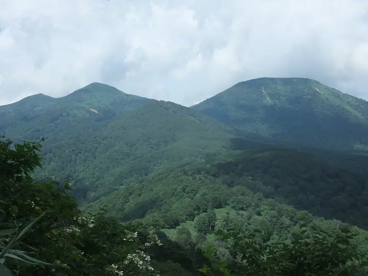
Mount Mitsudake (1,159 m) is the higher of the twin Heraidake summits on the border between Shingo Village and Towada City in Aomori Prefecture, paired with Ōkomagatake (1,144 m). Lying southeast of the Lake Towada outer rim, its summit harbours large old Japanese yew ("onko") trees and offers panoramic views of Lake Towada and the Hakkōda, Iwaki, and Iwate ranges. From the Hirakozawa trailhead, the route via Ōkomagatake reaches the summit in about 2 hours 40 minutes. The peak is listed in the Tōhoku 100 and Aomori 110.
Mount Mitsudake at a glance
- Weather: The most settled day in the next 7 days is Mon, November 9: cloudy, gusts up to 15 m/s. Wed, Nov 4, Fri, Nov 6, Sat, Nov 7, Sun, Nov 8: strong wind (gusts up to 26 m/s).
Mount Mitsudake weather (hourly, 14 days)
Sunrise today 06:07, sunset 16:32
| Tue, 11/3 | Wed, 11/4 | Thu, 11/5 | Fri, 11/6 | Sat, 11/7 | Sun, 11/8 | Mon, 11/9 | Tue, 11/10 | Wed, 11/11 | Thu, 11/12 | Fri, 11/13 | Sat, 11/14 | Sun, 11/15 | Mon, 11/16 | Tue, 11/17 | |||||||||||||||||||||||||||||||||||||||||||||||||||||||||||||||||||||||
|---|---|---|---|---|---|---|---|---|---|---|---|---|---|---|---|---|---|---|---|---|---|---|---|---|---|---|---|---|---|---|---|---|---|---|---|---|---|---|---|---|---|---|---|---|---|---|---|---|---|---|---|---|---|---|---|---|---|---|---|---|---|---|---|---|---|---|---|---|---|---|---|---|---|---|---|---|---|---|---|---|---|---|---|---|---|
| Japan time | 15 | 17 | 19 | 21 | 23 | 1 | 3 | 5 | 7 | 9 | 11 | 13 | 15 | 18 | 21 | 0 | 3 | 6 | 9 | 12 | 15 | 18 | 21 | 0 | 3 | 6 | 9 | 12 | 15 | 18 | 21 | 0 | 3 | 6 | 9 | 12 | 15 | 18 | 21 | 0 | 3 | 6 | 9 | 12 | 15 | 18 | 21 | 0 | 3 | 6 | 9 | 15 | 21 | 3 | 9 | 15 | 21 | 3 | 9 | 15 | 21 | 3 | 9 | 15 | 21 | 3 | 9 | 15 | 21 | 3 | 9 | 15 | 21 | 3 | 9 | 15 | 21 | 3 | 9 | 15 | 21 | 3 | 9 | 15 | |
  |  | | | | |   | |  | | | | | | | | |   |   | | |   | | |   |   |   |   | | | | | |   |   |   |   | | |   | | | | | | | | | | |   | | | | | |   | |   | | | | | | | | | | | | | |  | | | | | |   | |   | | | | ||
| Temperature | °C | 4° | 1° | 0° | 0° | 0° | 1° | 2° | 3° | 3° | 6° | 7° | 8° | 7° | 1° | -1° | 1° | 2° | 3° | 6° | 7° | 7° | 6° | 6° | 6° | 5° | 6° | 8° | 9° | 8° | 4° | 2° | -1° | -2° | -2° | -1° | -1° | -1° | -2° | -3° | -3° | -3° | -3° | -1° | 1° | 0° | -2° | -2° | -2° | -1° | -2° | -1° | -1° | -3° | -4° | -1° | 0° | -2° | -2° | -3° | -1° | -4° | -4° | 0° | 2° | -1° | -2° | -1° | -1° | -4° | -5° | 0° | 4° | -2° | -2° | 4° | 7° | 3° | 3° | 4° | 0° | -3° | -3° | 0° | 2° |
| Precipitation | mm | 0.3 | 0.6 | 1.7 | 2.5 | 3.9 | 3.8 | 0.4 | 0.8 | 1.0 | 0.2 | 0.4 | 0.9 | 0.8 | 0.7 | 0.7 | 0.1 | 0.1 | 0.1 | 0.2 | 0.6 | 11 | 20 | 4.3 | 0.5 | 1.3 | 0.3 | 2.0 | 0.8 | 2.4 | 1.1 | 0.2 | |||||||||||||||||||||||||||||||||||||||||||||||||||||
| New snow | cm | <.1 | <.1 | 0.4 | 0.8 | 0.7 | 0.6 | 0.6 | <.1 | <.1 | <.1 | <.1 | <.1 | 0.2 | 2.3 | 11 | 1.9 | <.1 | <.1 | 0.2 | 0.2 | ||||||||||||||||||||||||||||||||||||||||||||||||||||||||||||||||
| Snow depth | cm | 0 | 0 | 0 | 0 | 0 | 0 | 0 | 0 | 0 | 0 | 0 | 0 | 0 | 0 | 0 | 0 | 0 | 0 | 0 | 0 | 0 | 0 | 0 | 0 | 0 | 0 | 0 | 0 | 0 | 0 | 0 | 0 | 0 | 0 | 0 | <1 | <1 | <1 | <1 | <1 | <1 | <1 | <1 | <1 | <1 | <1 | 0 | 0 | 0 | 0 | 0 | 0 | 0 | 0 | 0 | 0 | <1 | <1 | 6 | 5 | 5 | 4 | 3 | 2 | <1 | <1 | <1 | <1 | <1 | <1 | <1 | 0 | 0 | 0 | 0 | 0 | 0 | 0 | 0 | 0 | 0 | <1 | 0 | 0 |
| Wind | m/s | 7 | 4 | 4 | 4 | 4 | 6 | 7 | 7 | 6 | 5 | 4 | 3 | 3 | 3 | 1 | 1 | 0 | 1 | 1 | 3 | 1 | 1 | 1 | 2 | 3 | 3 | 4 | 7 | 7 | 9 | 10 | 8 | 8 | 7 | 8 | 9 | 8 | 7 | 7 | 7 | 7 | 7 | 9 | 10 | 10 | 8 | 5 | 4 | 4 | 3 | 5 | 4 | 3 | 2 | 1 | 5 | 3 | 4 | 7 | 3 | 2 | 3 | 4 | 5 | 3 | 1 | 4 | 4 | 1 | 1 | 2 | 3 | 3 | 3 | 3 | 2 | 3 | 2 | 2 | 4 | 3 | 2 | 4 | 4 |
| Wind gusts | m/s | 18 | 16 | 11 | 12 | 12 | 15 | 18 | 18 | 18 | 15 | 13 | 10 | 8 | 7 | 6 | 3 | 3 | 5 | 5 | 7 | 7 | 4 | 5 | 5 | 7 | 8 | 10 | 18 | 21 | 23 | 25 | 24 | 21 | 20 | 21 | 25 | 23 | 21 | 18 | 18 | 18 | 17 | 22 | 25 | 26 | 25 | 19 | 13 | 11 | 11 | 13 | 15 | 11 | 7 | 6 | 12 | 13 | 9 | 18 | 17 | 7 | 7 | 10 | 13 | 13 | 9 | 11 | 13 | 9 | 4 | 7 | 9 | 8 | 8 | 8 | 7 | 8 | 8 | 7 | 12 | 11 | 9 | 10 | 12 |
| Wind dir. | ↓ | ↓ | ↓ | ↓ | ↓ | ↓ | ↓ | ↓ | ↓ | ↓ | ↓ | ↓ | ↓ | ↓ | ↓ | ↓ | ↓ | ↓ | ↓ | ↓ | ↓ | ↓ | ↓ | ↓ | ↓ | ↓ | ↓ | ↓ | ↓ | ↓ | ↓ | ↓ | ↓ | ↓ | ↓ | ↓ | ↓ | ↓ | ↓ | ↓ | ↓ | ↓ | ↓ | ↓ | ↓ | ↓ | ↓ | ↓ | ↓ | ↓ | ↓ | ↓ | ↓ | ↓ | ↓ | ↓ | ↓ | ↓ | ↓ | ↓ | ↓ | ↓ | ↓ | ↓ | ↓ | ↓ | ↓ | ↓ | ↓ | ↓ | ↓ | ↓ | ↓ | ↓ | ↓ | ↓ | ↓ | ↓ | ↓ | ↓ | ↓ | ↓ | ↓ | ↓ | |
Huts, campsites and lodging near Mount Mitsudake
Campsites
- 平子沢キャンプ場
Lists that include Mount Mitsudake
Tohoku 100 Famous Mountains · 110 Mountains of Aomori · Elevations of 1003 Mountains of Japan · 1000 Mountains of Japan
Mount Mitsudake facts
- Also known as
- 戸来岳
- Elevation
- 1,159 m
- Location
- Shingo, Aomori
40.452927, 141.001604 - Website
- www.japan47go.travel
- Wikipedia
- ja.wikipedia.org