
Mount Maya
摩耶山
Kobe, Hyogo · Elevation 702 m
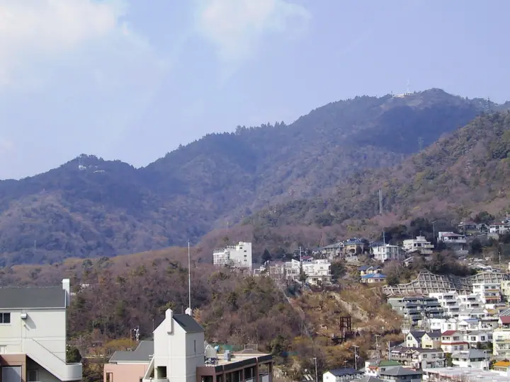
Mount Maya is a 702 m peak in Nada Ward of Kobe City, Hyōgo Prefecture, and one of the principal summits of the Rokkō range. Its name comes from Kōbō Daishi enshrining a statue of Maya-fujin, the mother of the Buddha, at Tōri-tenjō-ji on its slopes; it was historically called Hasshū-rei ('Eight-Province Ridge'). The Kikuseidai viewing platform near the summit offers one of Japan's Three Great Night Views, often called the 'ten-million-dollar night view', and the mountain is served by the Maya View Line cable car and ropeway as well as the Rokkō traverse route. It lies within Setonaikai National Park and is counted on the Kansai Hyakumeizan and Furusato Hyōgo 100 Mountains.
Mount Maya at a glance
- Weather: The most settled day in the next 7 days is Mon, November 9: clear, gusts up to 6 m/s.
- Route: The shortest is Mount Maya and Kikuseidai via Ueno Road Out-and-Back: about 3 h 26 min, 5.5 km, about 620 m of climbing.
Mount Maya weather (hourly, 14 days)
Sunrise today 06:21, sunset 17:05
| Tue, 11/3 | Wed, 11/4 | Thu, 11/5 | Fri, 11/6 | Sat, 11/7 | Sun, 11/8 | Mon, 11/9 | Tue, 11/10 | Wed, 11/11 | Thu, 11/12 | Fri, 11/13 | Sat, 11/14 | Sun, 11/15 | Mon, 11/16 | Tue, 11/17 | |||||||||||||||||||||||||||||||||||||||||||||||||||||||||||||||||||||||
|---|---|---|---|---|---|---|---|---|---|---|---|---|---|---|---|---|---|---|---|---|---|---|---|---|---|---|---|---|---|---|---|---|---|---|---|---|---|---|---|---|---|---|---|---|---|---|---|---|---|---|---|---|---|---|---|---|---|---|---|---|---|---|---|---|---|---|---|---|---|---|---|---|---|---|---|---|---|---|---|---|---|---|---|---|---|
| Japan time | 15 | 17 | 19 | 21 | 23 | 1 | 3 | 5 | 7 | 9 | 11 | 13 | 15 | 18 | 21 | 0 | 3 | 6 | 9 | 12 | 15 | 18 | 21 | 0 | 3 | 6 | 9 | 12 | 15 | 18 | 21 | 0 | 3 | 6 | 9 | 12 | 15 | 18 | 21 | 0 | 3 | 6 | 9 | 12 | 15 | 18 | 21 | 0 | 3 | 6 | 9 | 15 | 21 | 3 | 9 | 15 | 21 | 3 | 9 | 15 | 21 | 3 | 9 | 15 | 21 | 3 | 9 | 15 | 21 | 3 | 9 | 15 | 21 | 3 | 9 | 15 | 21 | 3 | 9 | 15 | 21 | 3 | 9 | 15 | |
  |   |   | | | |  | | | | | | |   |   |   |   | |   | |  |  |   | | | | | | | | | | | | |   | | | | | | | | | | | | | | | |   | |   | | | | | | | |  | | | | | | | | | | | | | | | | | | | |  | | | ||
| Temperature | °C | 15° | 13° | 11° | 10° | 10° | 10° | 9° | 9° | 9° | 12° | 15° | 17° | 16° | 13° | 13° | 12° | 12° | 12° | 13° | 17° | 19° | 15° | 15° | 16° | 14° | 12° | 15° | 17° | 17° | 13° | 10° | 8° | 6° | 6° | 9° | 12° | 11° | 8° | 6° | 6° | 5° | 5° | 10° | 13° | 12° | 10° | 9° | 9° | 8° | 9° | 11° | 13° | 8° | 7° | 10° | 13° | 8° | 6° | 8° | 10° | 5° | 4° | 9° | 12° | 7° | 7° | 10° | 11° | 5° | 4° | 8° | 14° | 8° | 8° | 12° | 14° | 12° | 12° | 14° | 14° | 8° | 5° | 8° | 11° |
| Precipitation | mm | 3.2 | 6 | 1.6 | 1.5 | 0.3 | 1.3 | 0.7 | 0.7 | 0.5 | 0.1 | 3.0 | 1.4 | 0.3 | |||||||||||||||||||||||||||||||||||||||||||||||||||||||||||||||||||||||
| New snow | cm | ||||||||||||||||||||||||||||||||||||||||||||||||||||||||||||||||||||||||||||||||||||
| Snow depth | cm | 0 | 0 | 0 | 0 | 0 | 0 | 0 | 0 | 0 | 0 | 0 | 0 | 0 | 0 | 0 | 0 | 0 | 0 | 0 | 0 | 0 | 0 | 0 | 0 | 0 | 0 | 0 | 0 | 0 | 0 | 0 | 0 | 0 | 0 | 0 | 0 | 0 | 0 | 0 | 0 | 0 | 0 | 0 | 0 | 0 | 0 | 0 | 0 | 0 | 0 | 0 | 0 | 0 | 0 | 0 | 0 | 0 | 0 | 0 | 0 | 0 | 0 | 0 | 0 | 0 | 0 | 0 | 0 | 0 | 0 | 0 | 0 | 0 | 0 | 0 | 0 | 0 | 0 | 0 | 0 | 0 | 0 | 0 | 0 |
| Wind | m/s | 4 | 3 | 3 | 3 | 2 | 2 | 3 | 2 | 3 | 3 | 3 | 3 | 3 | 4 | 4 | 4 | 4 | 2 | 3 | 1 | 1 | 1 | 1 | 3 | 3 | 1 | 3 | 4 | 5 | 3 | 3 | 3 | 2 | 2 | 3 | 5 | 5 | 3 | 1 | 1 | 2 | 1 | 1 | 4 | 3 | 2 | 1 | 1 | 1 | 1 | 1 | 2 | 1 | 1 | 1 | 3 | 3 | 4 | 3 | 6 | 2 | 2 | 1 | 1 | 1 | 3 | 5 | 5 | 2 | 1 | 1 | 1 | 1 | 1 | 2 | 2 | 1 | 1 | 3 | 6 | 6 | 2 | 3 | 3 |
| Wind gusts | m/s | 9 | 10 | 8 | 8 | 8 | 7 | 8 | 8 | 8 | 9 | 8 | 8 | 8 | 9 | 10 | 10 | 9 | 8 | 6 | 6 | 4 | 3 | 4 | 10 | 13 | 9 | 8 | 11 | 13 | 12 | 10 | 10 | 10 | 8 | 9 | 14 | 14 | 14 | 9 | 6 | 6 | 6 | 6 | 10 | 11 | 9 | 6 | 4 | 4 | 4 | 4 | 6 | 7 | 4 | 6 | 13 | 10 | 13 | 12 | 17 | 16 | 7 | 5 | 6 | 5 | 8 | 14 | 16 | 13 | 8 | 6 | 5 | 6 | 4 | 6 | 7 | 8 | 8 | 9 | 16 | 17 | 15 | 9 | 11 |
| Wind dir. | ↓ | ↓ | ↓ | ↓ | ↓ | ↓ | ↓ | ↓ | ↓ | ↓ | ↓ | ↓ | ↓ | ↓ | ↓ | ↓ | ↓ | ↓ | ↓ | ↓ | ↓ | ↓ | ↓ | ↓ | ↓ | ↓ | ↓ | ↓ | ↓ | ↓ | ↓ | ↓ | ↓ | ↓ | ↓ | ↓ | ↓ | ↓ | ↓ | ↓ | ↓ | ↓ | ↓ | ↓ | ↓ | ↓ | ↓ | ↓ | ↓ | ↓ | ↓ | ↓ | ↓ | ↓ | ↓ | ↓ | ↓ | ↓ | ↓ | ↓ | ↓ | ↓ | ↓ | ↓ | ↓ | ↓ | ↓ | ↓ | ↓ | ↓ | ↓ | ↓ | ↓ | ↓ | ↓ | ↓ | ↓ | ↓ | ↓ | ↓ | ↓ | ↓ | ↓ | ↓ | |
Mount Maya hiking routes
- Mount Maya and Kikuseidai via Ueno Road Out-and-Back 5.5 km · Ascent 618 m Maya Cable Shita (Bus stop), Maya Cable (Station), 高尾通3 (Bus stop), 高尾通4 (Bus stop)
- Mount Maya and Kikuseidai via the Aotani and Ueno Trails 6.7 km · Ascent 652 m 青谷橋 (Bus stop), 青谷 (Bus stop), モータープール グリーンヴァレイ → Maya Cable Shita (Bus stop), Maya Cable (Station), 高尾通3 (Bus stop), 高尾通4 (Bus stop)
- Mount Maya Loop via Ueno-michi and Aotani-michi 8.7 km · Ascent 710 m Ojikoen (Station), 阪急王子公園 (Bus stop) (parking)
Hiking times are estimates calculated from the terrain.
Huts, campsites and lodging near Mount Maya
Campsites
- wild camping (pure cats tho)
Lodging
- Hôtel de MAYA
- 神戸市立自然の家 六甲施設
- 神戸自然の家 摩耶施設
- MAYA
- Rokkosan HOTEL
Lists that include Mount Maya
Illustrated Collection of Japan's Famous Mountains · Kansai 100 Famous Mountains · 100 Mountains of Our Home Hyogo · Full Rokko Mountain Traverse · Elevations of 1003 Mountains of Japan · 1000 Mountains of Japan
Mount Maya facts
- Also known as
- 八州嶺
- Elevation
- 702 m
- Location
- Kobe, Hyogo
34.732985, 135.204883 - National Park
- 瀬戸内海国立公園
- Website
- kobe-rokko.jp
- Trail Map
- www.city.kobe.lg.jp (PDF)
- Access Information
- kobe-rokko.jp
- Wikipedia
- en.wikipedia.org