
Mount Arechi
荒地山
Ashiya, Hyogo · Elevation 549 m
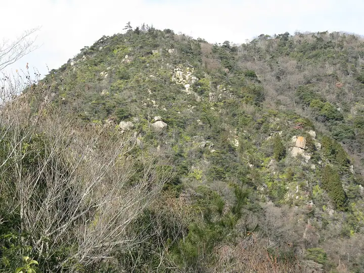
Mount Arechi is a 549 m granite peak in Okuyama district of Ashiya City, Hyogo Prefecture, set south of the main Rokko ridge between the Sumiyoshi River valley and the Kurogoe tributary of the Ashiya River. Famous rock features named the Iwa-Bashigo (Rock Ladder), Shin-Shichiemon-Iwakura and Castle Wall stand along its slopes, and the mountain forms part of the Ashiya Rock Garden, considered the birthplace of Japanese rock climbing. It lies within the Rokko area of Seto Inland Sea National Park.
Mount Arechi at a glance
- Weather: The most settled day in the next 7 days is Mon, November 9: clear, gusts up to 6 m/s.
- Route: The shortest is Mount Takao, Mount Arechi and Kazafuki Rock Loop: about 4 h 21 min, 8.3 km, about 610 m of climbing.
Mount Arechi weather (hourly, 14 days)
Sunrise today 06:21, sunset 17:04
| Tue, 11/3 | Wed, 11/4 | Thu, 11/5 | Fri, 11/6 | Sat, 11/7 | Sun, 11/8 | Mon, 11/9 | Tue, 11/10 | Wed, 11/11 | Thu, 11/12 | Fri, 11/13 | Sat, 11/14 | Sun, 11/15 | Mon, 11/16 | Tue, 11/17 | |||||||||||||||||||||||||||||||||||||||||||||||||||||||||||||||||||||||
|---|---|---|---|---|---|---|---|---|---|---|---|---|---|---|---|---|---|---|---|---|---|---|---|---|---|---|---|---|---|---|---|---|---|---|---|---|---|---|---|---|---|---|---|---|---|---|---|---|---|---|---|---|---|---|---|---|---|---|---|---|---|---|---|---|---|---|---|---|---|---|---|---|---|---|---|---|---|---|---|---|---|---|---|---|---|
| Japan time | 15 | 17 | 19 | 21 | 23 | 1 | 3 | 5 | 7 | 9 | 11 | 13 | 15 | 18 | 21 | 0 | 3 | 6 | 9 | 12 | 15 | 18 | 21 | 0 | 3 | 6 | 9 | 12 | 15 | 18 | 21 | 0 | 3 | 6 | 9 | 12 | 15 | 18 | 21 | 0 | 3 | 6 | 9 | 12 | 15 | 18 | 21 | 0 | 3 | 6 | 9 | 15 | 21 | 3 | 9 | 15 | 21 | 3 | 9 | 15 | 21 | 3 | 9 | 15 | 21 | 3 | 9 | 15 | 21 | 3 | 9 | 15 | 21 | 3 | 9 | 15 | 21 | 3 | 9 | 15 | 21 | 3 | 9 | 15 | |
  |   |   | | | |  | | | | | | |   |   |   |   | |   | |  |  |   | | | | | | | | | | | | |   | | | | | | | | | | | | | | | |   | |   | | | | | | | |  | | | | | | | | | | | | | | | | | | | |  | | | ||
| Temperature | °C | 16° | 14° | 12° | 11° | 11° | 11° | 10° | 10° | 10° | 13° | 16° | 18° | 17° | 14° | 14° | 13° | 13° | 13° | 14° | 18° | 20° | 16° | 16° | 17° | 15° | 13° | 16° | 18° | 18° | 14° | 11° | 9° | 7° | 7° | 10° | 13° | 12° | 9° | 7° | 7° | 6° | 6° | 11° | 14° | 13° | 11° | 10° | 10° | 9° | 10° | 12° | 14° | 9° | 8° | 11° | 14° | 9° | 7° | 9° | 11° | 6° | 5° | 10° | 13° | 8° | 8° | 11° | 12° | 6° | 5° | 9° | 14° | 9° | 9° | 13° | 15° | 13° | 13° | 15° | 15° | 9° | 6° | 9° | 12° |
| Precipitation | mm | 3.2 | 6 | 1.6 | 1.5 | 0.3 | 1.3 | 0.7 | 0.7 | 0.5 | 0.1 | 3.0 | 1.4 | 0.3 | |||||||||||||||||||||||||||||||||||||||||||||||||||||||||||||||||||||||
| New snow | cm | ||||||||||||||||||||||||||||||||||||||||||||||||||||||||||||||||||||||||||||||||||||
| Snow depth | cm | 0 | 0 | 0 | 0 | 0 | 0 | 0 | 0 | 0 | 0 | 0 | 0 | 0 | 0 | 0 | 0 | 0 | 0 | 0 | 0 | 0 | 0 | 0 | 0 | 0 | 0 | 0 | 0 | 0 | 0 | 0 | 0 | 0 | 0 | 0 | 0 | 0 | 0 | 0 | 0 | 0 | 0 | 0 | 0 | 0 | 0 | 0 | 0 | 0 | 0 | 0 | 0 | 0 | 0 | 0 | 0 | 0 | 0 | 0 | 0 | 0 | 0 | 0 | 0 | 0 | 0 | 0 | 0 | 0 | 0 | 0 | 0 | 0 | 0 | 0 | 0 | 0 | 0 | 0 | 0 | 0 | 0 | 0 | 0 |
| Wind | m/s | 4 | 3 | 3 | 3 | 2 | 2 | 3 | 2 | 3 | 3 | 3 | 3 | 3 | 4 | 4 | 4 | 4 | 2 | 3 | 1 | 1 | 1 | 1 | 3 | 3 | 1 | 3 | 4 | 5 | 3 | 3 | 3 | 2 | 2 | 3 | 5 | 5 | 3 | 1 | 1 | 2 | 1 | 1 | 4 | 3 | 2 | 1 | 1 | 1 | 1 | 1 | 2 | 1 | 1 | 1 | 3 | 3 | 4 | 3 | 6 | 2 | 2 | 1 | 1 | 1 | 3 | 5 | 5 | 2 | 1 | 1 | 1 | 1 | 1 | 2 | 2 | 1 | 1 | 3 | 6 | 6 | 2 | 3 | 3 |
| Wind gusts | m/s | 9 | 10 | 8 | 8 | 8 | 7 | 8 | 8 | 8 | 9 | 8 | 8 | 8 | 9 | 10 | 10 | 9 | 8 | 6 | 6 | 4 | 3 | 4 | 10 | 13 | 9 | 8 | 11 | 13 | 12 | 10 | 10 | 10 | 8 | 9 | 14 | 14 | 14 | 9 | 6 | 6 | 6 | 6 | 10 | 11 | 9 | 6 | 4 | 4 | 4 | 4 | 6 | 7 | 4 | 6 | 13 | 10 | 13 | 12 | 17 | 16 | 7 | 5 | 6 | 5 | 8 | 14 | 16 | 13 | 8 | 6 | 5 | 6 | 4 | 6 | 7 | 8 | 8 | 9 | 16 | 17 | 15 | 9 | 11 |
| Wind dir. | ↓ | ↓ | ↓ | ↓ | ↓ | ↓ | ↓ | ↓ | ↓ | ↓ | ↓ | ↓ | ↓ | ↓ | ↓ | ↓ | ↓ | ↓ | ↓ | ↓ | ↓ | ↓ | ↓ | ↓ | ↓ | ↓ | ↓ | ↓ | ↓ | ↓ | ↓ | ↓ | ↓ | ↓ | ↓ | ↓ | ↓ | ↓ | ↓ | ↓ | ↓ | ↓ | ↓ | ↓ | ↓ | ↓ | ↓ | ↓ | ↓ | ↓ | ↓ | ↓ | ↓ | ↓ | ↓ | ↓ | ↓ | ↓ | ↓ | ↓ | ↓ | ↓ | ↓ | ↓ | ↓ | ↓ | ↓ | ↓ | ↓ | ↓ | ↓ | ↓ | ↓ | ↓ | ↓ | ↓ | ↓ | ↓ | ↓ | ↓ | ↓ | ↓ | ↓ | ↓ | |
Mount Arechi hiking routes
Hiking times are estimates calculated from the terrain.
Huts, campsites and lodging near Mount Arechi
Campsites
- FBR (ForestBaseRokko)
Lodging
- ホテル竹園芦屋
- Business Inn Higashinada
- Grand Hotel Rokko SkyVilla
- Mikageso
- Sumiyoshi Ryokan
Mount Arechi facts
- Elevation
- 549 m
- Location
- Ashiya, Hyogo
34.754395, 135.282050 - National Park
- 瀬戸内海国立公園
- Website
- www.city.ashiya.lg.jp
- Trail Map
- www.city.ashiya.lg.jp (PDF)
- Wikipedia
- ja.wikipedia.org