
Mount Kurikoma
栗駒山
Kurihara, Miyagi · Elevation 1,626 m
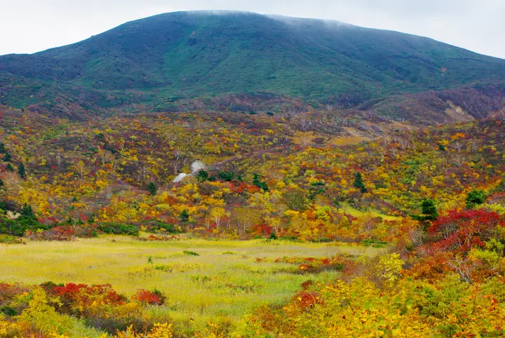
Mount Kurikoma is a 1,626.2 m active volcano in Kurihara, Miyagi Prefecture, whose mountain area also extends into Iwate and Akita. It is the principal summit of Kurikoma Quasi-National Park, also called Sukawadake on the Iwate side and Dainichidake on the Akita side. Its celebrated autumn foliage from late September to early October is known as the “carpet of the gods.” A first-class triangulation point marks the summit. Approaches include the Sukawa route from Sukawa Onsen, the Higashi-Kurikoma and Central routes from Iwakagami-daira, and the Magusadake route from Akita. Ichinoseki City hosts an annual mountain-opening safety ritual on the third Sunday of May. After volcanic-gas restrictions, the Sukawa route reopened on 18 July 2026, but is closed from 15 October 2026 until early June 2027 because winter snow prevents gas monitoring.
Mount Kurikoma at a glance
- Weather: The most settled day in the next 7 days is Wed, November 4: cloudy, gusts up to 14 m/s. Fri, Nov 6, Sat, Nov 7, Sun, Nov 8: strong wind (gusts up to 26 m/s).
- Route: The shortest is Mount Kurikoma Circuit via the Higashi-Kurikoma and Chuo Trails: about 4 h 1 min, 6.7 km, about 530 m of climbing.
Mount Kurikoma weather (hourly, 14 days)
Sunrise today 06:05, sunset 16:36
| Tue, 11/3 | Wed, 11/4 | Thu, 11/5 | Fri, 11/6 | Sat, 11/7 | Sun, 11/8 | Mon, 11/9 | Tue, 11/10 | Wed, 11/11 | Thu, 11/12 | Fri, 11/13 | Sat, 11/14 | Sun, 11/15 | Mon, 11/16 | Tue, 11/17 | |||||||||||||||||||||||||||||||||||||||||||||||||||||||||||||||||||||||
|---|---|---|---|---|---|---|---|---|---|---|---|---|---|---|---|---|---|---|---|---|---|---|---|---|---|---|---|---|---|---|---|---|---|---|---|---|---|---|---|---|---|---|---|---|---|---|---|---|---|---|---|---|---|---|---|---|---|---|---|---|---|---|---|---|---|---|---|---|---|---|---|---|---|---|---|---|---|---|---|---|---|---|---|---|---|
| Japan time | 21 | 23 | 1 | 3 | 5 | 7 | 9 | 11 | 13 | 15 | 17 | 19 | 21 | 0 | 3 | 6 | 9 | 12 | 15 | 18 | 21 | 0 | 3 | 6 | 9 | 12 | 15 | 18 | 21 | 0 | 3 | 6 | 9 | 12 | 15 | 18 | 21 | 0 | 3 | 6 | 9 | 12 | 15 | 18 | 21 | 0 | 3 | 6 | 9 | 12 | 15 | 21 | 3 | 9 | 15 | 21 | 3 | 9 | 15 | 21 | 3 | 9 | 15 | 21 | 3 | 9 | 15 | 21 | 3 | 9 | 15 | 21 | 3 | 9 | 15 | 21 | 3 | 9 | 15 | 21 | 3 | 9 | 15 | 21 | |
  | |  | |   |   | |   |   | | | | |   |   | |   | | | | | | |   | |   | | | | |   | |   | |   |   |   |   | | | | | | | | | | | |   | | | |  | | | | | |   | | | | | | | | | | | |  | | | | | | | | | | | | | ||
| Temperature | °C | -1° | -2° | -2° | -2° | -1° | 1° | 4° | 4° | 5° | 5° | 2° | 1° | 1° | 2° | 2° | 3° | 4° | 5° | 5° | 5° | 5° | 5° | 5° | 5° | 6° | 8° | 6° | 3° | 1° | -2° | -3° | -4° | -3° | -2° | -3° | -5° | -5° | -5° | -5° | -5° | -2° | -1° | -2° | -3° | -3° | -4° | -4° | -4° | -3° | -2° | -3° | -4° | -6° | -1° | 0° | -2° | -2° | -2° | -1° | -5° | -4° | -1° | 0° | -4° | -2° | -3° | -2° | -5° | -5° | -1° | 2° | -5° | -4° | 3° | 6° | 1° | 2° | 4° | 0° | -5° | -5° | -3° | -1° | -5° |
| Precipitation | mm | 1.1 | 4.8 | 7 | 3.8 | 0.7 | 0.6 | 1.0 | 0.6 | 0.3 | 0.7 | 1.1 | 0.9 | 0.8 | 1.6 | 4.0 | 2.4 | 0.9 | 1.4 | 1.5 | 1.5 | 1.5 | 0.9 | 0.3 | 0.2 | 0.2 | 0.5 | 1.3 | 1.1 | 0.7 | 0.3 | 0.8 | 6 | 1.8 | 0.7 | 0.8 | 4.0 | 1.4 | 0.1 | 0.1 | 1.0 | 4.7 | 1.6 | 3.2 | 4.8 | 0.3 | |||||||||||||||||||||||||||||||||||||||
| New snow | cm | 0.8 | 0.4 | 1.2 | 1.3 | 1.4 | 1.5 | 0.9 | 0.2 | 0.2 | 0.1 | 0.5 | 1.1 | 1.0 | 0.1 | <.1 | 0.3 | 0.4 | <.1 | <.1 | 0.1 | 1.4 | 0.3 | ||||||||||||||||||||||||||||||||||||||||||||||||||||||||||||||
| Snow depth | cm | 0 | 0 | 0 | 0 | 0 | 0 | 0 | 0 | 0 | 0 | 0 | 0 | 0 | 0 | 0 | 0 | 0 | 0 | 0 | 0 | 0 | 0 | 0 | 0 | 0 | 0 | 0 | 0 | 0 | 0 | 0 | 1 | 2 | 3 | 3 | 4 | 4 | 4 | 4 | 4 | 4 | 3 | 3 | 2 | 2 | 2 | 2 | 2 | 2 | 2 | <1 | <1 | <1 | <1 | <1 | <1 | 0 | 0 | 0 | 0 | 0 | 0 | 0 | 0 | 0 | 0 | 0 | 0 | 0 | 0 | 0 | 0 | 0 | 0 | 0 | 0 | 0 | 0 | 0 | <1 | <1 | <1 | <1 | 0 |
| Wind | m/s | 3 | 2 | 3 | 3 | 3 | 3 | 4 | 4 | 3 | 2 | 1 | 2 | 3 | 4 | 3 | 2 | 2 | 4 | 3 | 2 | 1 | 1 | 2 | 3 | 5 | 7 | 7 | 7 | 7 | 7 | 6 | 6 | 5 | 7 | 5 | 6 | 6 | 6 | 7 | 8 | 10 | 8 | 7 | 5 | 4 | 2 | 2 | 1 | 0 | 2 | 2 | 2 | 1 | 1 | 5 | 3 | 2 | 6 | 5 | 3 | 3 | 4 | 4 | 1 | 2 | 6 | 8 | 5 | 3 | 3 | 2 | 0 | 1 | 1 | 1 | 1 | 2 | 3 | 6 | 9 | 5 | 4 | 3 | 1 |
| Wind gusts | m/s | 10 | 9 | 8 | 10 | 11 | 11 | 13 | 14 | 10 | 8 | 5 | 7 | 10 | 11 | 11 | 9 | 8 | 11 | 12 | 9 | 6 | 5 | 7 | 10 | 15 | 20 | 22 | 21 | 19 | 19 | 19 | 19 | 18 | 25 | 24 | 22 | 19 | 19 | 20 | 23 | 26 | 26 | 23 | 20 | 14 | 11 | 7 | 6 | 5 | 6 | 7 | 11 | 6 | 5 | 13 | 15 | 10 | 16 | 17 | 14 | 9 | 11 | 11 | 11 | 7 | 16 | 22 | 21 | 14 | 10 | 10 | 7 | 4 | 4 | 6 | 7 | 7 | 8 | 18 | 26 | 23 | 15 | 11 | 9 |
| Wind dir. | ↓ | ↓ | ↓ | ↓ | ↓ | ↓ | ↓ | ↓ | ↓ | ↓ | ↓ | ↓ | ↓ | ↓ | ↓ | ↓ | ↓ | ↓ | ↓ | ↓ | ↓ | ↓ | ↓ | ↓ | ↓ | ↓ | ↓ | ↓ | ↓ | ↓ | ↓ | ↓ | ↓ | ↓ | ↓ | ↓ | ↓ | ↓ | ↓ | ↓ | ↓ | ↓ | ↓ | ↓ | ↓ | ↓ | ↓ | ↓ | ↓ | ↓ | ↓ | ↓ | ↓ | ↓ | ↓ | ↓ | ↓ | ↓ | ↓ | ↓ | ↓ | ↓ | ↓ | ↓ | ↓ | ↓ | ↓ | ↓ | ↓ | ↓ | ↓ | ↓ | ↓ | ↓ | ↓ | ↓ | ↓ | ↓ | ↓ | ↓ | ↓ | ↓ | ↓ | ↓ | |
Mount Kurikoma live cameras
Mount Kurikoma hiking routes
- Mount Kurikoma Circuit via the Higashi-Kurikoma and Chuo Trails 6.7 km · Ascent 527 m parking
- Mount Kurikoma Nature Trail from Sukawa Kōgen Onsen Out-and-Back 8.5 km · Ascent 584 m parking
- Mount Kurikoma and Mount Magusadake Loop from Sukawa Plateau 13.0 km · Ascent 807 m parking
Hiking times are estimates calculated from the terrain.
Huts, campsites and lodging near Mount Kurikoma
Mountain huts
Campsites
- 一関市須川野営場
- 栗駒高原オートキャンプ場
- 須川湖キャンプ場
Lodging
- Sukawakogenonsen
- Kurikomasanso
- ハイルザーム栗駒
Lists that include Mount Kurikoma
Japan 200 Famous Mountains · Japan's 300 Famous Mountains · 100 Famous Mountains of Flowers · New 100 Famous Flower Mountains · 100 Famous Mountains with First-order Triangulation Points · New Japan 100 Famous Mountains · 100 Famous Hot Spring Mountains · Tohoku 100 Famous Mountains · Iwate 100 Famous Mountains · Elevations of 1003 Mountains of Japan · 1000 Mountains of Japan
Mount Kurikoma facts
- Also known as
- 須川岳 · 大日岳 · Kurikomayama
- Elevation
- 1,626 m
- Location
- Kurihara, Miyagi
38.960915, 140.788422 - National Park
- 栗駒国定公園
- Volcano
- Active volcano (栗駒山)
- Website
- www.ichitabi.jp
- Trail Map
- www.ichitabi.jp (PDF)
- Access Information
- www.rinya.maff.go.jp
- Wikipedia
- ja.wikipedia.org