
Mount Kirishima
韓国岳
霧島山(新燃岳) レベル2(火口周辺規制) · issued October 17 at 11:00
Kobayashi, Miyazaki / Ebino, Miyazaki / Kirishima, Kagoshima · Elevation 1,700 m
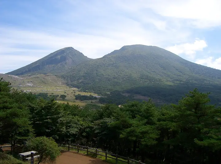
Mount Kirishima is the collective name for a cluster of volcanoes spanning Ebino, Kobayashi, and Takaharu in Miyazaki and Kirishima City in Kagoshima; its highest peak is Karakunidake at 1,700 m. As the centrepiece of Kirishima-Kinkōwan National Park, the range includes Mount Takachiho-no-mine, the legendary site of the descent of the heavenly grandson Ninigi-no-mikoto. Active volcanoes such as Shinmoedake and Ohachi line the chain, and access is gated by JMA volcanic alert levels. Karakunidake holds a crater nine hundred metres across and three hundred metres deep at its summit; trails climb from the Ebino-Kōgen plateau, with diversions in operation when the Iōyama area is restricted.
Mount Kirishima at a glance
- Weather: The most settled day in the next 7 days is Sun, November 8: clear, gusts up to 6 m/s. Fri, Nov 6: strong wind (gusts up to 15 m/s).
- Route: The shortest is Mount Karakuni and Lake Onami Loop from Ebino Plateau: about 4 h 57 min, 8.4 km, about 630 m of climbing.
Mount Kirishima weather (hourly, 14 days)
Sunrise today 06:34, sunset 17:26
| Tue, 11/3 | Wed, 11/4 | Thu, 11/5 | Fri, 11/6 | Sat, 11/7 | Sun, 11/8 | Mon, 11/9 | Tue, 11/10 | Wed, 11/11 | Thu, 11/12 | Fri, 11/13 | Sat, 11/14 | Sun, 11/15 | Mon, 11/16 | Tue, 11/17 | |||||||||||||||||||||||||||||||||||||||||||||||||||||||||||||||||||||||
|---|---|---|---|---|---|---|---|---|---|---|---|---|---|---|---|---|---|---|---|---|---|---|---|---|---|---|---|---|---|---|---|---|---|---|---|---|---|---|---|---|---|---|---|---|---|---|---|---|---|---|---|---|---|---|---|---|---|---|---|---|---|---|---|---|---|---|---|---|---|---|---|---|---|---|---|---|---|---|---|---|---|---|---|---|---|
| Japan time | 15 | 17 | 19 | 21 | 23 | 1 | 3 | 5 | 7 | 9 | 11 | 13 | 15 | 18 | 21 | 0 | 3 | 6 | 9 | 12 | 15 | 18 | 21 | 0 | 3 | 6 | 9 | 12 | 15 | 18 | 21 | 0 | 3 | 6 | 9 | 12 | 15 | 18 | 21 | 0 | 3 | 6 | 9 | 12 | 15 | 18 | 21 | 0 | 3 | 6 | 9 | 15 | 21 | 3 | 9 | 15 | 21 | 3 | 9 | 15 | 21 | 3 | 9 | 15 | 21 | 3 | 9 | 15 | 21 | 3 | 9 | 15 | 21 | 3 | 9 | 15 | 21 | 3 | 9 | 15 | 21 | 3 | 9 | 15 | |
  | |  |   | | |   | |   |   | | |   | |   | | |   | |   | |   | | | | |  | | |  | | | | | | | | | | | | | | | | | | | |   | | | | | | | | | | | | | | | | | | |  | | | | | | | | | |   | | |   | | | ||
| Temperature | °C | 14° | 11° | 7° | 7° | 8° | 6° | 6° | 7° | 8° | 10° | 12° | 13° | 12° | 9° | 9° | 9° | 9° | 9° | 12° | 16° | 13° | 12° | 12° | 10° | 10° | 8° | 8° | 12° | 11° | 7° | 4° | 3° | 2° | 0° | 4° | 8° | 8° | 3° | 3° | 3° | 2° | 2° | 7° | 9° | 9° | 7° | 5° | 6° | 7° | 6° | 9° | 10° | 5° | 2° | 5° | 8° | 2° | 1° | 5° | 8° | 2° | 2° | 6° | 9° | 2° | 1° | 7° | 10° | 3° | 3° | 9° | 10° | 7° | 8° | 10° | 11° | 9° | 10° | 10° | 13° | 6° | 7° | 9° | 12° |
| Precipitation | mm | 0.1 | 0.5 | 0.2 | 0.7 | 2.0 | 0.7 | 0.3 | 0.3 | 12 | 8 | 0.2 | 0.1 | 0.1 | |||||||||||||||||||||||||||||||||||||||||||||||||||||||||||||||||||||||
| New snow | cm | ||||||||||||||||||||||||||||||||||||||||||||||||||||||||||||||||||||||||||||||||||||
| Snow depth | cm | 0 | 0 | 0 | 0 | 0 | 0 | 0 | 0 | 0 | 0 | 0 | 0 | 0 | 0 | 0 | 0 | 0 | 0 | 0 | 0 | 0 | 0 | 0 | 0 | 0 | 0 | 0 | 0 | 0 | 0 | 0 | 0 | 0 | 0 | 0 | 0 | 0 | 0 | 0 | 0 | 0 | 0 | 0 | 0 | 0 | 0 | 0 | 0 | 0 | 0 | 0 | 0 | 0 | 0 | 0 | 0 | 0 | 0 | 0 | 0 | 0 | 0 | 0 | 0 | 0 | 0 | 0 | 0 | 0 | 0 | 0 | 0 | 0 | 0 | 0 | 0 | 0 | 0 | 0 | 0 | 0 | 0 | 0 | 0 |
| Wind | m/s | 1 | 1 | 1 | 1 | 1 | 1 | 1 | 1 | 2 | 3 | 3 | 3 | 2 | 1 | 2 | 1 | 1 | 1 | 1 | 3 | 2 | 2 | 4 | 4 | 4 | 3 | 4 | 4 | 4 | 4 | 4 | 4 | 3 | 3 | 3 | 3 | 3 | 1 | 0 | 0 | 1 | 1 | 2 | 0 | 0 | 1 | 1 | 0 | 1 | 1 | 1 | 2 | 1 | 2 | 3 | 4 | 3 | 2 | 1 | 2 | 0 | 0 | 0 | 2 | 1 | 1 | 1 | 0 | 1 | 1 | 2 | 2 | 2 | 3 | 4 | 3 | 1 | 3 | 3 | 3 | 1 | 1 | 1 | 1 |
| Wind gusts | m/s | 6 | 6 | 5 | 4 | 3 | 4 | 5 | 5 | 7 | 8 | 10 | 11 | 10 | 8 | 9 | 9 | 6 | 5 | 6 | 11 | 12 | 11 | 15 | 15 | 15 | 15 | 13 | 15 | 15 | 16 | 16 | 16 | 16 | 15 | 13 | 12 | 11 | 9 | 4 | 3 | 2 | 5 | 6 | 6 | 4 | 3 | 4 | 4 | 6 | 7 | 7 | 8 | 8 | 8 | 11 | 14 | 14 | 13 | 10 | 8 | 8 | 4 | 4 | 6 | 6 | 4 | 5 | 5 | 5 | 4 | 6 | 9 | 8 | 12 | 14 | 15 | 11 | 12 | 13 | 13 | 11 | 4 | 5 | 7 |
| Wind dir. | ↓ | ↓ | ↓ | ↓ | ↓ | ↓ | ↓ | ↓ | ↓ | ↓ | ↓ | ↓ | ↓ | ↓ | ↓ | ↓ | ↓ | ↓ | ↓ | ↓ | ↓ | ↓ | ↓ | ↓ | ↓ | ↓ | ↓ | ↓ | ↓ | ↓ | ↓ | ↓ | ↓ | ↓ | ↓ | ↓ | ↓ | ↓ | ↓ | ↓ | ↓ | ↓ | ↓ | ↓ | ↓ | ↓ | ↓ | ↓ | ↓ | ↓ | ↓ | ↓ | ↓ | ↓ | ↓ | ↓ | ↓ | ↓ | ↓ | ↓ | ↓ | ↓ | ↓ | ↓ | ↓ | ↓ | ↓ | ↓ | ↓ | ↓ | ↓ | ↓ | ↓ | ↓ | ↓ | ↓ | ↓ | ↓ | ↓ | ↓ | ↓ | ↓ | ↓ | ↓ | |
Mount Kirishima live cameras
Mount Kirishima hiking routes
- Mount Karakuni and Lake Onami Loop from Ebino Plateau 8.4 km · Ascent 630 m parking
- Mount Karakuni and Onamiike Crater Lake Loop from Onamiike Trailhead 8.6 km · Ascent 799 m parking
- Mount Karakuni and Onamiike Crater Lake Loop 9.8 km · Ascent 721 m parking
Hiking times are estimates calculated from the terrain.
Huts, campsites and lodging near Mount Kirishima
Mountain huts
Campsites
- Ebino Plateau Camp Village
Lodging
- ホテル ピコ ラナイ えびの高原
- 新燃荘
- Kirishima Hotel
Lists that include Mount Kirishima
100 Famous Japanese Mountains · Japan 200 Famous Mountains · Japan's 300 Famous Mountains · 100 Famous Mountains of Flowers · New 100 Famous Flower Mountains · 100 Famous Mountains with First-order Triangulation Points · Illustrated Collection of Japan's Famous Mountains · Kyushu 100 Famous Mountains · 100 Mountains of Miyazaki · Elevations of 1003 Mountains of Japan · 1000 Mountains of Japan
Mount Kirishima facts
- Elevation
- 1,700 m
- Location
- Kobayashi, Miyazaki / Ebino, Miyazaki / Kirishima, Kagoshima
31.934204, 130.861566 - National Park
- 霧島錦江湾国立公園
- Volcano
- Active volcano (霧島山)
- Website
- www.kanko-miyazaki.jp
- Trail Map
- www.city.ebino.lg.jp (PDF)
- Access Information
- www.city.ebino.lg.jp
- Wikipedia
- ja.wikipedia.org