
Mount Shiratori
白鳥山
霧島山(新燃岳) レベル2(火口周辺規制) · issued October 17 at 11:00
Ebino, Miyazaki · Elevation 1,363 m
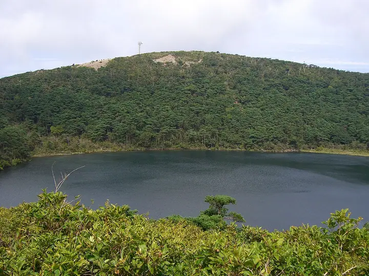
A 1,363.1 m volcano forming the northwestern flank of the Kirishima range in southern Ebino City, Miyazaki Prefecture. Byakushi Pond lies south of the summit and the Rokkannon Miike maar southeast, with Shiratori Shrine and Shiratori Onsen at the northern foot. The path linking Byakushi Pond, Rokkannon Miike and Fudo Pond from Ebino Highland is a popular hike in Kirishima-Kinkowan National Park. The summit overlooks Mount Karakuni and Sakurajima.
Mount Shiratori at a glance
- Weather: The most settled day in the next 7 days is Sun, November 8: clear, gusts up to 6 m/s. Fri, Nov 6: strong wind (gusts up to 15 m/s).
- Route: The shortest is Ebino Plateau Mount Shiratori–Rokkannon Miike Circuit: about 2 h 50 min, 5.1 km, about 280 m of climbing.
Mount Shiratori weather (hourly, 14 days)
Sunrise today 06:34, sunset 17:26
| Tue, 11/3 | Wed, 11/4 | Thu, 11/5 | Fri, 11/6 | Sat, 11/7 | Sun, 11/8 | Mon, 11/9 | Tue, 11/10 | Wed, 11/11 | Thu, 11/12 | Fri, 11/13 | Sat, 11/14 | Sun, 11/15 | Mon, 11/16 | Tue, 11/17 | |||||||||||||||||||||||||||||||||||||||||||||||||||||||||||||||||||||||
|---|---|---|---|---|---|---|---|---|---|---|---|---|---|---|---|---|---|---|---|---|---|---|---|---|---|---|---|---|---|---|---|---|---|---|---|---|---|---|---|---|---|---|---|---|---|---|---|---|---|---|---|---|---|---|---|---|---|---|---|---|---|---|---|---|---|---|---|---|---|---|---|---|---|---|---|---|---|---|---|---|---|---|---|---|---|
| Japan time | 15 | 17 | 19 | 21 | 23 | 1 | 3 | 5 | 7 | 9 | 11 | 13 | 15 | 18 | 21 | 0 | 3 | 6 | 9 | 12 | 15 | 18 | 21 | 0 | 3 | 6 | 9 | 12 | 15 | 18 | 21 | 0 | 3 | 6 | 9 | 12 | 15 | 18 | 21 | 0 | 3 | 6 | 9 | 12 | 15 | 18 | 21 | 0 | 3 | 6 | 9 | 15 | 21 | 3 | 9 | 15 | 21 | 3 | 9 | 15 | 21 | 3 | 9 | 15 | 21 | 3 | 9 | 15 | 21 | 3 | 9 | 15 | 21 | 3 | 9 | 15 | 21 | 3 | 9 | 15 | 21 | 3 | 9 | 15 | |
  | |  |   | | |   | |   |   | | |   | |   | | |   | |   | |   | | | | |  | | |  | | | | | | | | | | | | | | | | | | | |   | | | | | | | | | | | | | | | | | | |  | | | | | | | | | |   | | |   | | | ||
| Temperature | °C | 16° | 13° | 10° | 10° | 10° | 9° | 9° | 9° | 10° | 12° | 14° | 15° | 14° | 11° | 12° | 11° | 11° | 11° | 14° | 18° | 15° | 14° | 14° | 12° | 12° | 11° | 11° | 14° | 14° | 10° | 6° | 5° | 4° | 2° | 6° | 10° | 10° | 5° | 5° | 5° | 4° | 4° | 9° | 11° | 11° | 9° | 7° | 8° | 9° | 8° | 11° | 12° | 7° | 4° | 7° | 10° | 4° | 3° | 7° | 10° | 4° | 4° | 8° | 11° | 4° | 3° | 9° | 13° | 6° | 5° | 11° | 12° | 9° | 10° | 12° | 13° | 11° | 12° | 12° | 15° | 8° | 9° | 11° | 14° |
| Precipitation | mm | 0.1 | 0.5 | 0.2 | 0.7 | 2.0 | 0.7 | 0.3 | 0.3 | 12 | 8 | 0.2 | 0.1 | 0.1 | |||||||||||||||||||||||||||||||||||||||||||||||||||||||||||||||||||||||
| New snow | cm | ||||||||||||||||||||||||||||||||||||||||||||||||||||||||||||||||||||||||||||||||||||
| Snow depth | cm | 0 | 0 | 0 | 0 | 0 | 0 | 0 | 0 | 0 | 0 | 0 | 0 | 0 | 0 | 0 | 0 | 0 | 0 | 0 | 0 | 0 | 0 | 0 | 0 | 0 | 0 | 0 | 0 | 0 | 0 | 0 | 0 | 0 | 0 | 0 | 0 | 0 | 0 | 0 | 0 | 0 | 0 | 0 | 0 | 0 | 0 | 0 | 0 | 0 | 0 | 0 | 0 | 0 | 0 | 0 | 0 | 0 | 0 | 0 | 0 | 0 | 0 | 0 | 0 | 0 | 0 | 0 | 0 | 0 | 0 | 0 | 0 | 0 | 0 | 0 | 0 | 0 | 0 | 0 | 0 | 0 | 0 | 0 | 0 |
| Wind | m/s | 1 | 1 | 1 | 1 | 1 | 1 | 1 | 1 | 2 | 3 | 3 | 3 | 2 | 1 | 2 | 1 | 1 | 1 | 1 | 3 | 2 | 2 | 4 | 4 | 4 | 3 | 4 | 4 | 4 | 4 | 4 | 4 | 3 | 3 | 3 | 3 | 3 | 1 | 0 | 0 | 1 | 1 | 2 | 0 | 0 | 1 | 1 | 0 | 1 | 1 | 1 | 2 | 1 | 2 | 3 | 4 | 3 | 2 | 1 | 2 | 0 | 0 | 0 | 2 | 1 | 1 | 1 | 0 | 1 | 1 | 2 | 2 | 2 | 3 | 4 | 3 | 1 | 3 | 3 | 3 | 1 | 1 | 1 | 1 |
| Wind gusts | m/s | 6 | 6 | 5 | 4 | 3 | 4 | 5 | 5 | 7 | 8 | 10 | 11 | 10 | 8 | 9 | 9 | 6 | 5 | 6 | 11 | 12 | 11 | 15 | 15 | 15 | 15 | 13 | 15 | 15 | 16 | 16 | 16 | 16 | 15 | 13 | 12 | 11 | 9 | 4 | 3 | 2 | 5 | 6 | 6 | 4 | 3 | 4 | 4 | 6 | 7 | 7 | 8 | 8 | 8 | 11 | 14 | 14 | 13 | 10 | 8 | 8 | 4 | 4 | 6 | 6 | 4 | 5 | 5 | 5 | 4 | 6 | 9 | 8 | 12 | 14 | 15 | 11 | 12 | 13 | 13 | 11 | 4 | 5 | 7 |
| Wind dir. | ↓ | ↓ | ↓ | ↓ | ↓ | ↓ | ↓ | ↓ | ↓ | ↓ | ↓ | ↓ | ↓ | ↓ | ↓ | ↓ | ↓ | ↓ | ↓ | ↓ | ↓ | ↓ | ↓ | ↓ | ↓ | ↓ | ↓ | ↓ | ↓ | ↓ | ↓ | ↓ | ↓ | ↓ | ↓ | ↓ | ↓ | ↓ | ↓ | ↓ | ↓ | ↓ | ↓ | ↓ | ↓ | ↓ | ↓ | ↓ | ↓ | ↓ | ↓ | ↓ | ↓ | ↓ | ↓ | ↓ | ↓ | ↓ | ↓ | ↓ | ↓ | ↓ | ↓ | ↓ | ↓ | ↓ | ↓ | ↓ | ↓ | ↓ | ↓ | ↓ | ↓ | ↓ | ↓ | ↓ | ↓ | ↓ | ↓ | ↓ | ↓ | ↓ | ↓ | ↓ | |
Mount Shiratori hiking routes
Hiking times are estimates calculated from the terrain.
Huts, campsites and lodging near Mount Shiratori
Mountain huts
Campsites
- Ebino Plateau Camp Village
Lodging
- ホテル ピコ ラナイ えびの高原
Lists that include Mount Shiratori
Mount Shiratori facts
- Elevation
- 1,363 m
- Location
- Ebino, Miyazaki
31.956595, 130.838107 - National Park
- 霧島錦江湾国立公園
- Volcano
- Active volcano (霧島山)
- Website
- www.city.ebino.lg.jp
- Trail Map
- www.city.ebino.lg.jp
- Access Information
- ebino-ecomuseum.go.jp
- Wikipedia
- ja.wikipedia.org