
Mount Kama
鎌ヶ岳
Komono, Mie · Elevation 1,161 m
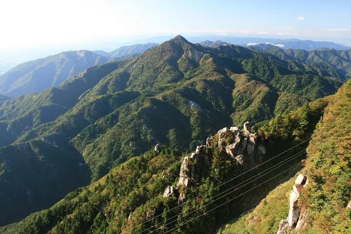
Mount Kama is a 1,161 m peak in Komono, Mie Prefecture, near the border with Koka in Shiga, in the southern Suzuka Mountains within Suzuka Quasi-National Park. Its sharply pointed summit has earned it the nickname "Spear of the Suzuka", and it is reached via several routes including Buhei Pass, Nagaishi Valley, and Mitsukuchi Valley.
Mount Kama at a glance
- Weather: The most settled day in the next 7 days is Wed, November 4: clear, gusts up to 6 m/s. Fri, Nov 6, Sat, Nov 7: strong wind (gusts up to 19 m/s).
- Route: The shortest is Mount Kamagatake from Buhei Pass: about 2 h 24 min, 3.4 km, about 400 m of climbing.
Mount Kama weather (hourly, 14 days)
Sunrise today 06:16, sunset 16:59
| Tue, 11/3 | Wed, 11/4 | Thu, 11/5 | Fri, 11/6 | Sat, 11/7 | Sun, 11/8 | Mon, 11/9 | Tue, 11/10 | Wed, 11/11 | Thu, 11/12 | Fri, 11/13 | Sat, 11/14 | Sun, 11/15 | Mon, 11/16 | Tue, 11/17 | |||||||||||||||||||||||||||||||||||||||||||||||||||||||||||||||||||||||
|---|---|---|---|---|---|---|---|---|---|---|---|---|---|---|---|---|---|---|---|---|---|---|---|---|---|---|---|---|---|---|---|---|---|---|---|---|---|---|---|---|---|---|---|---|---|---|---|---|---|---|---|---|---|---|---|---|---|---|---|---|---|---|---|---|---|---|---|---|---|---|---|---|---|---|---|---|---|---|---|---|---|---|---|---|---|
| Japan time | 15 | 17 | 19 | 21 | 23 | 1 | 3 | 5 | 7 | 9 | 11 | 13 | 15 | 18 | 21 | 0 | 3 | 6 | 9 | 12 | 15 | 18 | 21 | 0 | 3 | 6 | 9 | 12 | 15 | 18 | 21 | 0 | 3 | 6 | 9 | 12 | 15 | 18 | 21 | 0 | 3 | 6 | 9 | 12 | 15 | 18 | 21 | 0 | 3 | 6 | 9 | 15 | 21 | 3 | 9 | 15 | 21 | 3 | 9 | 15 | 21 | 3 | 9 | 15 | 21 | 3 | 9 | 15 | 21 | 3 | 9 | 15 | 21 | 3 | 9 | 15 | 21 | 3 | 9 | 15 | 21 | 3 | 9 | 15 | |
 |  |   | | | | | |   | | |   |   |   | |   | |   |   | |   |  |   | | | |   | | | | | | | | | | | | | | | | | | | | | | | | | | |   | | |   | | | | |  | | | | | | | | | | | | | | | | | | | | | | | ||
| Temperature | °C | 12° | 9° | 6° | 6° | 5° | 5° | 5° | 4° | 3° | 11° | 13° | 13° | 11° | 10° | 9° | 9° | 9° | 9° | 12° | 13° | 15° | 11° | 9° | 9° | 10° | 10° | 11° | 14° | 13° | 8° | 7° | 6° | 4° | 4° | 5° | 6° | 6° | 4° | 2° | 2° | 2° | 2° | 6° | 8° | 7° | 4° | 4° | 4° | 4° | 4° | 7° | 9° | 3° | 2° | 8° | 10° | 3° | 2° | 5° | 6° | 2° | -1° | 5° | 8° | 1° | 3° | 7° | 7° | 2° | -2° | 7° | 9° | 5° | 6° | 9° | 9° | 8° | 9° | 11° | 11° | 4° | 2° | 5° | 8° |
| Precipitation | mm | 1.5 | 1.3 | 0.6 | 1.1 | 0.3 | 0.2 | 1.3 | 1.0 | 0.5 | 0.4 | 0.1 | 0.6 | 0.9 | 0.4 | 0.2 | 0.1 | 0.5 | 0.3 | 0.7 | 3.6 | 4.5 | 0.6 | 1.1 | |||||||||||||||||||||||||||||||||||||||||||||||||||||||||||||
| New snow | cm | ||||||||||||||||||||||||||||||||||||||||||||||||||||||||||||||||||||||||||||||||||||
| Snow depth | cm | 0 | 0 | 0 | 0 | 0 | 0 | 0 | 0 | 0 | 0 | 0 | 0 | 0 | 0 | 0 | 0 | 0 | 0 | 0 | 0 | 0 | 0 | 0 | 0 | 0 | 0 | 0 | 0 | 0 | 0 | 0 | 0 | 0 | 0 | 0 | 0 | 0 | 0 | 0 | 0 | 0 | 0 | 0 | 0 | 0 | 0 | 0 | 0 | 0 | 0 | 0 | 0 | 0 | 0 | 0 | 0 | 0 | 0 | 0 | 0 | 0 | 0 | 0 | 0 | 0 | 0 | 0 | 0 | 0 | 0 | 0 | 0 | 0 | 0 | 0 | 0 | 0 | 0 | 0 | 0 | 0 | 0 | 0 | 0 |
| Wind | m/s | 3 | 3 | 2 | 2 | 2 | 2 | 2 | 2 | 2 | 0 | 1 | 2 | 2 | 0 | 1 | 1 | 0 | 0 | 0 | 1 | 1 | 0 | 0 | 0 | 2 | 3 | 4 | 7 | 6 | 5 | 5 | 6 | 5 | 4 | 6 | 6 | 6 | 4 | 3 | 3 | 2 | 3 | 4 | 5 | 3 | 2 | 2 | 2 | 2 | 2 | 2 | 4 | 2 | 1 | 2 | 4 | 2 | 6 | 6 | 7 | 3 | 2 | 2 | 4 | 2 | 2 | 4 | 6 | 3 | 2 | 1 | 2 | 0 | 0 | 2 | 2 | 1 | 0 | 2 | 5 | 4 | 4 | 2 | 1 |
| Wind gusts | m/s | 9 | 9 | 8 | 7 | 8 | 7 | 8 | 8 | 6 | 5 | 5 | 6 | 6 | 5 | 8 | 8 | 5 | 4 | 4 | 3 | 4 | 3 | 3 | 5 | 8 | 10 | 11 | 18 | 19 | 17 | 16 | 17 | 18 | 15 | 17 | 19 | 19 | 18 | 13 | 10 | 10 | 10 | 12 | 13 | 13 | 9 | 6 | 5 | 5 | 6 | 7 | 12 | 11 | 6 | 6 | 12 | 12 | 20 | 20 | 21 | 18 | 11 | 8 | 11 | 11 | 9 | 11 | 18 | 17 | 10 | 6 | 8 | 5 | 4 | 6 | 9 | 6 | 7 | 7 | 17 | 16 | 13 | 12 | 7 |
| Wind dir. | ↓ | ↓ | ↓ | ↓ | ↓ | ↓ | ↓ | ↓ | ↓ | ↓ | ↓ | ↓ | ↓ | ↓ | ↓ | ↓ | ↓ | ↓ | ↓ | ↓ | ↓ | ↓ | ↓ | ↓ | ↓ | ↓ | ↓ | ↓ | ↓ | ↓ | ↓ | ↓ | ↓ | ↓ | ↓ | ↓ | ↓ | ↓ | ↓ | ↓ | ↓ | ↓ | ↓ | ↓ | ↓ | ↓ | ↓ | ↓ | ↓ | ↓ | ↓ | ↓ | ↓ | ↓ | ↓ | ↓ | ↓ | ↓ | ↓ | ↓ | ↓ | ↓ | ↓ | ↓ | ↓ | ↓ | ↓ | ↓ | ↓ | ↓ | ↓ | ↓ | ↓ | ↓ | ↓ | ↓ | ↓ | ↓ | ↓ | ↓ | ↓ | ↓ | ↓ | ↓ | |
Mount Kama hiking routes
- Mount Kamagatake from Buhei Pass 3.4 km · Ascent 404 m parking
- Mount Kamagatake via Buhei Pass 3.8 km · Ascent 424 m parking
- Mount Kamagatake and Yaiichigatake via Nagaishi Valley and Ridge 6.6 km · Ascent 768 m parking
- Mount Mizusawa and Mount Kamagatake Circuit from Miyatsuma Gorge 9.6 km · Ascent 1,021 m parking
- Suzuka Loop over Gozaisho to Kamagatake, Descending the Nagaishi Ridge 9.3 km · Ascent 1,139 m parking
- Mount Kamagatake, Mount Mizusawa, and Mount Nyūdō Loop from Miyazuma Gorge 11.1 km · Ascent 1,383 m parking
Hiking times are estimates calculated from the terrain.
Huts, campsites and lodging near Mount Kama
Mountain huts
Campsites
- 宮妻峡 バンガロー・キャンプ場
- 伊勢谷小屋
- 西山荘
Lodging
- 一の谷山荘
- 三慶園
- 湯の山温泉 希望荘
- ホテルウェルネス鈴鹿路
- グリーンホテル
Lists that include Mount Kama
Kansai 100 Famous Mountains · Tokai 100 Mountains · Kinki 100 Famous Mountains · Omi 100 Mountains · Suzuka 7 Mountains · 1000 Mountains of Japan
Mount Kama facts
- Also known as
- Kamagatake
- Elevation
- 1,161 m
- Location
- Komono, Mie
35.001417, 136.421319 - National Park
- 鈴鹿国定公園
- Website
- www.kankomie.or.jp
- Wikipedia
- ja.wikipedia.org