
Mount Watamuki
綿向山
Hino, Shiga · Elevation 1,110 m
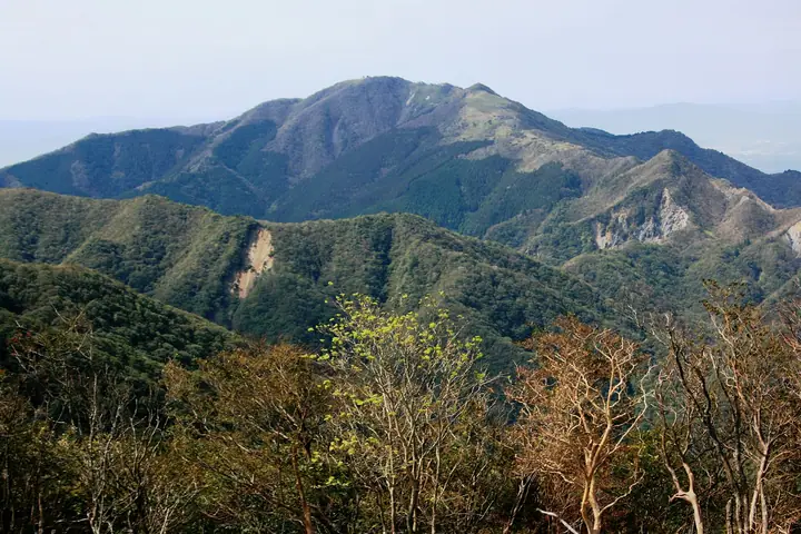
Mt. Watamukiyama is a 1,110-meter peak in Hino Town, Gamō District, Shiga Prefecture, one of the highest summits on the Shiga side of the Suzuka Range. Long revered as the sacred mountain of Watamuki Shrine, its graceful "feminine" profile makes it popular with beginners. Hino Town designates November 10 as "Watamukiyama Day" after the mountain's elevation; rest stations along the trail include the 5th-station Azami-goya, the 7th-station Gyōja-dō surrounded by beech forest, the 5.3-meter Youth Tower built in 1970, and the Kinmeisui spring (the only water source) at the 8th station.
Mount Watamuki at a glance
- Weather: The most settled day in the next 7 days is Wed, November 4: cloudy, gusts up to 8 m/s. Fri, Nov 6, Sat, Nov 7: strong wind (gusts up to 21 m/s).
- Route: The shortest is Mount Watamuki from Miyukibashi via Mount Ryūō: about 6 h 45 min, 11.9 km, about 1,100 m of climbing.
Mount Watamuki weather (hourly, 14 days)
Sunrise today 06:17, sunset 17:00
| Tue, 11/3 | Wed, 11/4 | Thu, 11/5 | Fri, 11/6 | Sat, 11/7 | Sun, 11/8 | Mon, 11/9 | Tue, 11/10 | Wed, 11/11 | Thu, 11/12 | Fri, 11/13 | Sat, 11/14 | Sun, 11/15 | Mon, 11/16 | Tue, 11/17 | |||||||||||||||||||||||||||||||||||||||||||||||||||||||||||||||||||||||
|---|---|---|---|---|---|---|---|---|---|---|---|---|---|---|---|---|---|---|---|---|---|---|---|---|---|---|---|---|---|---|---|---|---|---|---|---|---|---|---|---|---|---|---|---|---|---|---|---|---|---|---|---|---|---|---|---|---|---|---|---|---|---|---|---|---|---|---|---|---|---|---|---|---|---|---|---|---|---|---|---|---|---|---|---|---|
| Japan time | 21 | 23 | 1 | 3 | 5 | 7 | 9 | 11 | 13 | 15 | 17 | 19 | 21 | 0 | 3 | 6 | 9 | 12 | 15 | 18 | 21 | 0 | 3 | 6 | 9 | 12 | 15 | 18 | 21 | 0 | 3 | 6 | 9 | 12 | 15 | 18 | 21 | 0 | 3 | 6 | 9 | 12 | 15 | 18 | 21 | 0 | 3 | 6 | 9 | 12 | 15 | 21 | 3 | 9 | 15 | 21 | 3 | 9 | 15 | 21 | 3 | 9 | 15 | 21 | 3 | 9 | 15 | 21 | 3 | 9 | 15 | 21 | 3 | 9 | 15 | 21 | 3 | 9 | 15 | 21 | 3 | 9 | 15 | 21 | |
 |   | | |   |   |   | |   | |   | | |   | |   |   | | |   | | | | | |   | | |  | | | |   | | | | | | | | | | | | | | | |  | | |   | | | | | | | | |  | | | | | | | | | | | | | | | | | | | | | | | | ||
| Temperature | °C | 7° | 7° | 6° | 6° | 5° | 6° | 11° | 14° | 13° | 12° | 11° | 9° | 10° | 9° | 9° | 9° | 12° | 14° | 17° | 11° | 11° | 11° | 11° | 10° | 10° | 14° | 12° | 9° | 8° | 6° | 5° | 4° | 5° | 6° | 6° | 4° | 3° | 4° | 3° | 2° | 5° | 8° | 7° | 4° | 4° | 4° | 5° | 5° | 7° | 11° | 10° | 4° | 3° | 9° | 10° | 5° | 2° | 5° | 6° | 3° | 1° | 6° | 8° | 3° | 3° | 6° | 7° | 2° | -1° | 8° | 10° | 5° | 7° | 10° | 10° | 9° | 10° | 11° | 11° | 4° | 3° | 5° | 8° | 4° |
| Precipitation | mm | 1.7 | 0.1 | 1.8 | 1.0 | 0.3 | 0.2 | 1.1 | 6 | 0.2 | 1.6 | 0.9 | 0.3 | 0.7 | 1.3 | 0.5 | 0.2 | 0.1 | 0.5 | 0.5 | 0.1 | 1.3 | 2.9 | 3.9 | 0.6 | 1.7 | |||||||||||||||||||||||||||||||||||||||||||||||||||||||||||
| New snow | cm | ||||||||||||||||||||||||||||||||||||||||||||||||||||||||||||||||||||||||||||||||||||
| Snow depth | cm | 0 | 0 | 0 | 0 | 0 | 0 | 0 | 0 | 0 | 0 | 0 | 0 | 0 | 0 | 0 | 0 | 0 | 0 | 0 | 0 | 0 | 0 | 0 | 0 | 0 | 0 | 0 | 0 | 0 | 0 | 0 | 0 | 0 | 0 | 0 | 0 | 0 | 0 | 0 | 0 | 0 | 0 | 0 | 0 | 0 | 0 | 0 | 0 | 0 | 0 | 0 | 0 | 0 | 0 | 0 | 0 | 0 | 0 | 0 | 0 | 0 | 0 | 0 | 0 | 0 | 0 | 0 | 0 | 0 | 0 | 0 | 0 | 0 | 0 | 0 | 0 | 0 | 0 | 0 | 0 | 0 | 0 | 0 | 0 |
| Wind | m/s | 3 | 3 | 3 | 3 | 3 | 2 | 1 | 0 | 1 | 2 | 1 | 2 | 2 | 0 | 1 | 1 | 0 | 1 | 1 | 1 | 3 | 2 | 5 | 4 | 5 | 6 | 6 | 6 | 6 | 7 | 6 | 5 | 6 | 7 | 7 | 5 | 4 | 4 | 4 | 4 | 4 | 4 | 4 | 2 | 1 | 0 | 1 | 1 | 2 | 4 | 5 | 1 | 0 | 2 | 4 | 4 | 7 | 7 | 7 | 4 | 2 | 3 | 4 | 1 | 2 | 4 | 7 | 4 | 2 | 1 | 2 | 2 | 2 | 3 | 3 | 2 | 0 | 3 | 7 | 5 | 5 | 3 | 2 | 1 |
| Wind gusts | m/s | 9 | 8 | 9 | 9 | 9 | 8 | 4 | 4 | 5 | 7 | 6 | 7 | 8 | 9 | 6 | 4 | 4 | 3 | 4 | 4 | 8 | 10 | 13 | 15 | 14 | 18 | 18 | 18 | 19 | 19 | 19 | 17 | 18 | 19 | 21 | 20 | 16 | 13 | 13 | 13 | 13 | 12 | 12 | 9 | 6 | 4 | 4 | 5 | 6 | 13 | 13 | 12 | 4 | 7 | 13 | 12 | 21 | 21 | 22 | 19 | 12 | 8 | 11 | 11 | 8 | 13 | 19 | 18 | 11 | 6 | 9 | 6 | 6 | 8 | 11 | 9 | 9 | 9 | 19 | 19 | 15 | 14 | 9 | 6 |
| Wind dir. | ↓ | ↓ | ↓ | ↓ | ↓ | ↓ | ↓ | ↓ | ↓ | ↓ | ↓ | ↓ | ↓ | ↓ | ↓ | ↓ | ↓ | ↓ | ↓ | ↓ | ↓ | ↓ | ↓ | ↓ | ↓ | ↓ | ↓ | ↓ | ↓ | ↓ | ↓ | ↓ | ↓ | ↓ | ↓ | ↓ | ↓ | ↓ | ↓ | ↓ | ↓ | ↓ | ↓ | ↓ | ↓ | ↓ | ↓ | ↓ | ↓ | ↓ | ↓ | ↓ | ↓ | ↓ | ↓ | ↓ | ↓ | ↓ | ↓ | ↓ | ↓ | ↓ | ↓ | ↓ | ↓ | ↓ | ↓ | ↓ | ↓ | ↓ | ↓ | ↓ | ↓ | ↓ | ↓ | ↓ | ↓ | ↓ | ↓ | ↓ | ↓ | ↓ | ↓ | ↓ | |
Mount Watamuki hiking routes
Hiking times are estimates calculated from the terrain.
Huts, campsites and lodging near Mount Watamuki
Mountain huts
Lists that include Mount Watamuki
Mount Watamuki facts
- Also known as
- Watamukiyama
- Elevation
- 1,110 m
- Location
- Hino, Shiga
35.013689, 136.341754 - National Park
- 鈴鹿国定公園
- Website
- www.town.shiga-hino.lg.jp