
Hatomine
羽鳥峰
Komono, Mie · Elevation 860 m
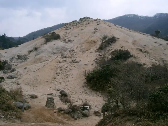
Hatomine (also "Hato-mine") is a peak on the main ridge of the Suzuka Mountains, in Komono Town (Mie), near the border with Higashiomi City (Shiga), south of Mount Shaka and Mount Neko, within Suzuka Quasi-National Park. Its summit area is bare white granite sand, and the Hatomine Marsh lies along the nearby ridge. It is usually climbed from the Asake Valley on the Mie side.
Hatomine at a glance
- Weather: The most settled day in the next 7 days is Wed, November 4: clear, gusts up to 6 m/s. Fri, Nov 6, Sat, Nov 7: strong wind (gusts up to 19 m/s).
- Route: The shortest is Mount Shakagatake, Nekodake, and Hatorimine Loop from Asake Valley: about 5 h 13 min, 8.7 km, about 830 m of climbing.
Hatomine weather (hourly, 14 days)
Sunrise today 06:16, sunset 16:59
| Tue, 11/3 | Wed, 11/4 | Thu, 11/5 | Fri, 11/6 | Sat, 11/7 | Sun, 11/8 | Mon, 11/9 | Tue, 11/10 | Wed, 11/11 | Thu, 11/12 | Fri, 11/13 | Sat, 11/14 | Sun, 11/15 | Mon, 11/16 | Tue, 11/17 | |||||||||||||||||||||||||||||||||||||||||||||||||||||||||||||||||||||||
|---|---|---|---|---|---|---|---|---|---|---|---|---|---|---|---|---|---|---|---|---|---|---|---|---|---|---|---|---|---|---|---|---|---|---|---|---|---|---|---|---|---|---|---|---|---|---|---|---|---|---|---|---|---|---|---|---|---|---|---|---|---|---|---|---|---|---|---|---|---|---|---|---|---|---|---|---|---|---|---|---|---|---|---|---|---|
| Japan time | 15 | 17 | 19 | 21 | 23 | 1 | 3 | 5 | 7 | 9 | 11 | 13 | 15 | 18 | 21 | 0 | 3 | 6 | 9 | 12 | 15 | 18 | 21 | 0 | 3 | 6 | 9 | 12 | 15 | 18 | 21 | 0 | 3 | 6 | 9 | 12 | 15 | 18 | 21 | 0 | 3 | 6 | 9 | 12 | 15 | 18 | 21 | 0 | 3 | 6 | 9 | 15 | 21 | 3 | 9 | 15 | 21 | 3 | 9 | 15 | 21 | 3 | 9 | 15 | 21 | 3 | 9 | 15 | 21 | 3 | 9 | 15 | 21 | 3 | 9 | 15 | 21 | 3 | 9 | 15 | 21 | 3 | 9 | 15 | |
 |  |   | | | | | |   | | |   |   |   | |   | |   |   | |   |  |   | | | |   | | | | | | | | | | | | | | | | | | | | | | | | | | |   | | |   | | | | |  | | | | | | | | | | | | | | | | | | | | | | | ||
| Temperature | °C | 14° | 11° | 8° | 8° | 7° | 7° | 7° | 5° | 5° | 13° | 15° | 15° | 13° | 11° | 11° | 11° | 11° | 11° | 14° | 15° | 17° | 12° | 11° | 11° | 12° | 12° | 13° | 16° | 15° | 10° | 9° | 8° | 6° | 6° | 7° | 8° | 8° | 5° | 4° | 4° | 4° | 4° | 8° | 10° | 9° | 6° | 6° | 5° | 6° | 6° | 9° | 11° | 5° | 4° | 10° | 12° | 5° | 4° | 7° | 8° | 4° | 1° | 7° | 10° | 3° | 5° | 9° | 9° | 3° | 0° | 9° | 11° | 7° | 8° | 11° | 11° | 10° | 11° | 12° | 13° | 6° | 4° | 7° | 9° |
| Precipitation | mm | 1.5 | 1.3 | 0.6 | 1.1 | 0.3 | 0.2 | 1.3 | 1.0 | 0.5 | 0.4 | 0.1 | 0.6 | 0.9 | 0.4 | 0.2 | 0.1 | 0.5 | 0.3 | 0.7 | 3.6 | 4.5 | 0.6 | 1.1 | |||||||||||||||||||||||||||||||||||||||||||||||||||||||||||||
| New snow | cm | ||||||||||||||||||||||||||||||||||||||||||||||||||||||||||||||||||||||||||||||||||||
| Snow depth | cm | 0 | 0 | 0 | 0 | 0 | 0 | 0 | 0 | 0 | 0 | 0 | 0 | 0 | 0 | 0 | 0 | 0 | 0 | 0 | 0 | 0 | 0 | 0 | 0 | 0 | 0 | 0 | 0 | 0 | 0 | 0 | 0 | 0 | 0 | 0 | 0 | 0 | 0 | 0 | 0 | 0 | 0 | 0 | 0 | 0 | 0 | 0 | 0 | 0 | 0 | 0 | 0 | 0 | 0 | 0 | 0 | 0 | 0 | 0 | 0 | 0 | 0 | 0 | 0 | 0 | 0 | 0 | 0 | 0 | 0 | 0 | 0 | 0 | 0 | 0 | 0 | 0 | 0 | 0 | 0 | 0 | 0 | 0 | 0 |
| Wind | m/s | 3 | 3 | 2 | 2 | 2 | 2 | 2 | 2 | 2 | 0 | 1 | 2 | 2 | 0 | 1 | 1 | 0 | 0 | 0 | 1 | 1 | 0 | 0 | 0 | 2 | 3 | 4 | 7 | 6 | 5 | 5 | 6 | 5 | 4 | 6 | 6 | 6 | 4 | 3 | 3 | 2 | 3 | 4 | 5 | 3 | 2 | 2 | 2 | 2 | 2 | 2 | 4 | 2 | 1 | 2 | 4 | 2 | 6 | 6 | 7 | 3 | 2 | 2 | 4 | 2 | 2 | 4 | 6 | 3 | 2 | 1 | 2 | 0 | 0 | 2 | 2 | 1 | 0 | 2 | 5 | 4 | 4 | 2 | 1 |
| Wind gusts | m/s | 9 | 9 | 8 | 7 | 8 | 7 | 8 | 8 | 6 | 5 | 5 | 6 | 6 | 5 | 8 | 8 | 5 | 4 | 4 | 3 | 4 | 3 | 3 | 5 | 8 | 10 | 11 | 18 | 19 | 17 | 16 | 17 | 18 | 15 | 17 | 19 | 19 | 18 | 13 | 10 | 10 | 10 | 12 | 13 | 13 | 9 | 6 | 5 | 5 | 6 | 7 | 12 | 11 | 6 | 6 | 12 | 12 | 20 | 20 | 21 | 18 | 11 | 8 | 11 | 11 | 9 | 11 | 18 | 17 | 10 | 6 | 8 | 5 | 4 | 6 | 9 | 6 | 7 | 7 | 17 | 16 | 13 | 12 | 7 |
| Wind dir. | ↓ | ↓ | ↓ | ↓ | ↓ | ↓ | ↓ | ↓ | ↓ | ↓ | ↓ | ↓ | ↓ | ↓ | ↓ | ↓ | ↓ | ↓ | ↓ | ↓ | ↓ | ↓ | ↓ | ↓ | ↓ | ↓ | ↓ | ↓ | ↓ | ↓ | ↓ | ↓ | ↓ | ↓ | ↓ | ↓ | ↓ | ↓ | ↓ | ↓ | ↓ | ↓ | ↓ | ↓ | ↓ | ↓ | ↓ | ↓ | ↓ | ↓ | ↓ | ↓ | ↓ | ↓ | ↓ | ↓ | ↓ | ↓ | ↓ | ↓ | ↓ | ↓ | ↓ | ↓ | ↓ | ↓ | ↓ | ↓ | ↓ | ↓ | ↓ | ↓ | ↓ | ↓ | ↓ | ↓ | ↓ | ↓ | ↓ | ↓ | ↓ | ↓ | ↓ | ↓ | |
Hatomine hiking routes
Hiking times are estimates calculated from the terrain.
Huts, campsites and lodging near Hatomine
Mountain huts
Campsites
- 伊勢谷小屋
- 西山荘
- 八風キャンプ場
Lodging
- 一の谷山荘
- 湯の山温泉 希望荘
- 三慶園
Hatomine facts
- Elevation
- 860 m
- Location
- Komono, Mie
35.054425, 136.424301 - National Park
- 鈴鹿国定公園
- Wikipedia
- ja.wikipedia.org