
Mount Izari
漁岳
Sapporo, Hokkaido · Elevation 1,318 m
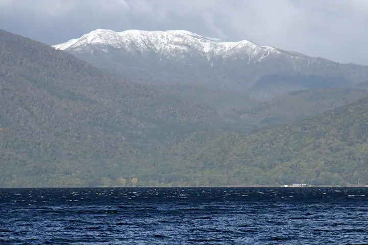
Mount Izari is a 1,317.7 m stratovolcano at the meeting point of Eniwa, Chitose, and Sapporo (Minami Ward) in Hokkaido, part of the Shikotsu volcanic system. The name comes from the Izari River, whose headwaters lie at the summit; the river's name derives from an Ainu term for a salmon- and trout-spawning stream. There is no maintained trail; the peak is reached by stream-climbing the Izari River or by a bushwhack ridge traverse from Mount Soranuma. The mountain lies within Shikotsu-Tōya National Park and is one of the 100 Famous Mountains of Hokkaido and the Sapporo 50 Peaks.
Mount Izari at a glance
- Weather: The most settled day in the next 7 days is Thu, November 5: cloudy, gusts up to 9 m/s. Fri, Nov 6, Sat, Nov 7, Sun, Nov 8: strong wind (gusts up to 25 m/s).
Mount Izari weather (hourly, 14 days)
Sunrise today 06:11, sunset 16:27
| Tue, 11/3 | Wed, 11/4 | Thu, 11/5 | Fri, 11/6 | Sat, 11/7 | Sun, 11/8 | Mon, 11/9 | Tue, 11/10 | Wed, 11/11 | Thu, 11/12 | Fri, 11/13 | Sat, 11/14 | Sun, 11/15 | Mon, 11/16 | Tue, 11/17 | |||||||||||||||||||||||||||||||||||||||||||||||||||||||||||||||||||||||
|---|---|---|---|---|---|---|---|---|---|---|---|---|---|---|---|---|---|---|---|---|---|---|---|---|---|---|---|---|---|---|---|---|---|---|---|---|---|---|---|---|---|---|---|---|---|---|---|---|---|---|---|---|---|---|---|---|---|---|---|---|---|---|---|---|---|---|---|---|---|---|---|---|---|---|---|---|---|---|---|---|---|---|---|---|---|
| Japan time | 21 | 23 | 1 | 3 | 5 | 7 | 9 | 11 | 13 | 15 | 17 | 19 | 21 | 0 | 3 | 6 | 9 | 12 | 15 | 18 | 21 | 0 | 3 | 6 | 9 | 12 | 15 | 18 | 21 | 0 | 3 | 6 | 9 | 12 | 15 | 18 | 21 | 0 | 3 | 6 | 9 | 12 | 15 | 18 | 21 | 0 | 3 | 6 | 9 | 12 | 15 | 21 | 3 | 9 | 15 | 21 | 3 | 9 | 15 | 21 | 3 | 9 | 15 | 21 | 3 | 9 | 15 | 21 | 3 | 9 | 15 | 21 | 3 | 9 | 15 | 21 | 3 | 9 | 15 | 21 | 3 | 9 | 15 | 21 | |
  |   |   |   | |   |   |  | | |  | | |   | | | |   | |   |   | | | |   |   | | | | | | |   | | | | | | | | | | | | | | | | | | |   | | | | | |   | | | | | | | | |   | | | | | | | | | | |   | | |  | | | | ||
| Temperature | °C | -4° | -3° | -3° | -2° | -2° | -2° | -1° | 1° | 2° | 1° | -3° | -4° | -4° | -3° | -2° | -1° | 5° | 5° | 5° | 2° | 4° | 4° | 4° | 4° | 5° | 8° | 6° | 0° | -3° | -5° | -7° | -7° | -6° | -5° | -6° | -5° | -6° | -6° | -6° | -7° | -5° | -5° | -6° | -7° | -7° | -7° | -7° | -7° | -6° | -5° | -7° | -9° | -9° | -5° | -4° | -7° | -7° | -3° | -2° | -8° | -6° | -3° | -3° | -6° | -9° | -7° | -6° | -6° | -6° | -3° | -1° | -7° | -2° | 2° | 3° | 2° | 0° | -2° | -4° | -7° | -8° | -3° | -2° | -5° |
| Precipitation | mm | 0.2 | 0.6 | 2.5 | 0.9 | 0.5 | 2.4 | 1.6 | 5 | 7 | 0.2 | 0.2 | 0.4 | 0.2 | 0.3 | 0.3 | 0.4 | 0.7 | 0.8 | 1.0 | 0.9 | 0.7 | 0.5 | 0.4 | 0.4 | 0.4 | 0.2 | 0.1 | 0.2 | 0.2 | 1.6 | 1.5 | 0.2 | 0.2 | 0.1 | 0.2 | 0.2 | 0.3 | 0.2 | 0.7 | 0.8 | 2.8 | 1.2 | 0.1 | |||||||||||||||||||||||||||||||||||||||||
| New snow | cm | 0.2 | 0.6 | 2.4 | 0.7 | <.1 | 0.1 | 0.3 | 0.3 | 0.4 | 0.7 | 0.8 | 1.0 | 0.9 | 0.7 | 0.5 | 0.4 | 0.4 | 0.3 | 0.2 | 0.1 | <.1 | <.1 | <.1 | <.1 | <.1 | 0.2 | 0.2 | <.1 | <.1 | 1.6 | 1.5 | 0.2 | 0.2 | <.1 | 0.1 | 0.2 | 0.2 | 0.5 | 0.7 | 0.1 | ||||||||||||||||||||||||||||||||||||||||||||
| Snow depth | cm | <1 | <1 | 3 | 3 | 3 | 3 | 3 | 3 | 3 | 2 | 2 | 2 | 2 | 2 | 2 | 2 | 2 | 1 | 1 | <1 | <1 | <1 | <1 | <1 | 0 | 0 | 0 | 0 | 0 | 0 | <1 | <1 | <1 | 2 | 2 | 3 | 3 | 3 | 4 | 5 | 6 | 6 | 6 | 6 | 6 | 6 | 6 | 6 | 6 | 6 | 6 | 6 | 6 | 6 | 5 | 5 | 6 | 7 | 7 | 7 | 7 | 7 | 7 | 7 | 7 | 7 | 7 | 7 | 7 | 7 | 7 | 6 | 6 | 5 | 3 | 1 | 1 | 1 | 2 | 2 | 2 | 1 | 1 | 1 |
| Wind | m/s | 2 | 3 | 4 | 3 | 4 | 4 | 4 | 2 | 1 | 1 | 1 | 2 | 2 | 3 | 3 | 3 | 2 | 2 | 1 | 2 | 3 | 1 | 1 | 0 | 2 | 4 | 6 | 7 | 6 | 7 | 7 | 7 | 9 | 9 | 8 | 7 | 7 | 6 | 5 | 5 | 6 | 6 | 6 | 4 | 2 | 2 | 2 | 2 | 3 | 4 | 3 | 1 | 1 | 1 | 2 | 1 | 2 | 2 | 2 | 1 | 1 | 2 | 3 | 2 | 1 | 5 | 3 | 2 | 2 | 1 | 0 | 2 | 3 | 3 | 3 | 3 | 2 | 3 | 5 | 4 | 3 | 1 | 2 | 1 |
| Wind gusts | m/s | 10 | 10 | 13 | 14 | 14 | 14 | 13 | 12 | 6 | 5 | 5 | 7 | 8 | 8 | 9 | 9 | 9 | 8 | 7 | 6 | 8 | 9 | 6 | 5 | 5 | 12 | 17 | 20 | 19 | 20 | 21 | 20 | 24 | 25 | 24 | 23 | 22 | 19 | 19 | 17 | 18 | 18 | 16 | 16 | 12 | 8 | 8 | 7 | 10 | 11 | 11 | 11 | 6 | 5 | 8 | 7 | 7 | 6 | 7 | 6 | 5 | 7 | 12 | 10 | 6 | 13 | 13 | 9 | 8 | 5 | 5 | 6 | 9 | 11 | 11 | 12 | 9 | 7 | 14 | 14 | 12 | 9 | 7 | 5 |
| Wind dir. | ↓ | ↓ | ↓ | ↓ | ↓ | ↓ | ↓ | ↓ | ↓ | ↓ | ↓ | ↓ | ↓ | ↓ | ↓ | ↓ | ↓ | ↓ | ↓ | ↓ | ↓ | ↓ | ↓ | ↓ | ↓ | ↓ | ↓ | ↓ | ↓ | ↓ | ↓ | ↓ | ↓ | ↓ | ↓ | ↓ | ↓ | ↓ | ↓ | ↓ | ↓ | ↓ | ↓ | ↓ | ↓ | ↓ | ↓ | ↓ | ↓ | ↓ | ↓ | ↓ | ↓ | ↓ | ↓ | ↓ | ↓ | ↓ | ↓ | ↓ | ↓ | ↓ | ↓ | ↓ | ↓ | ↓ | ↓ | ↓ | ↓ | ↓ | ↓ | ↓ | ↓ | ↓ | ↓ | ↓ | ↓ | ↓ | ↓ | ↓ | ↓ | ↓ | ↓ | ↓ | |
Lists that include Mount Izari
Mount Izari facts
- Elevation
- 1,318 m
- Location
- Sapporo, Hokkaido
42.821151, 141.235519 - National Park
- 支笏洞爺国立公園
- Website
- www.rinya.maff.go.jp
- Wikipedia
- ja.wikipedia.org