
Mount Iwaigame
祝瓶山
Nagai, Yamagata · Elevation 1,417 m
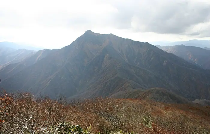
Mount Iwaigame is a 1,417.2 m peak extending across Oguni Town in Nishi-Okitama District and Nagai City in Yamagata Prefecture, sitting at the southern end of the Asahi Range with its northern ridge included in Bandai-Asahi National Park. Its sharp, perfectly pyramidal silhouette has earned it the local nickname "the Tōhoku Matterhorn," and it is listed in the Nihon Sanbyaku Meizan, the Yamagata Hyakumeizan, and the Tōhoku 100 Meizan. The two principal trails are the Nagai-side route from Iwaigame Sansō hut, which crosses the No-river and climbs via Kuwazumi-daira, and the Oguni-side route up the Suzufuri Ridge from Ōishi Bridge — both 6–7 hour intermediate-to-advanced round trips. The summit offers a 360° panorama, with the Asahi Range crowned by Ōasahi-dake to the north and the Iide Range to the south. The climbing season generally runs from early June to late October.
Mount Iwaigame at a glance
- Weather: The most settled day in the next 7 days is Wed, November 4: clear, gusts up to 7 m/s. Fri, Nov 6, Sat, Nov 7, Sun, Nov 8: strong wind (gusts up to 25 m/s).
- Route: The shortest is Oguni Mount Iwaigame, the Matterhorn of Tohoku, Return from the Hariudaira Trailhead: about 6 h 21 min, 9.1 km, about 1,090 m of climbing.
Mount Iwaigame weather (hourly, 14 days)
Sunrise today 06:08, sunset 16:40
| Tue, 11/3 | Wed, 11/4 | Thu, 11/5 | Fri, 11/6 | Sat, 11/7 | Sun, 11/8 | Mon, 11/9 | Tue, 11/10 | Wed, 11/11 | Thu, 11/12 | Fri, 11/13 | Sat, 11/14 | Sun, 11/15 | Mon, 11/16 | Tue, 11/17 | |||||||||||||||||||||||||||||||||||||||||||||||||||||||||||||||||||||||
|---|---|---|---|---|---|---|---|---|---|---|---|---|---|---|---|---|---|---|---|---|---|---|---|---|---|---|---|---|---|---|---|---|---|---|---|---|---|---|---|---|---|---|---|---|---|---|---|---|---|---|---|---|---|---|---|---|---|---|---|---|---|---|---|---|---|---|---|---|---|---|---|---|---|---|---|---|---|---|---|---|---|---|---|---|---|
| Japan time | 15 | 17 | 19 | 21 | 23 | 1 | 3 | 5 | 7 | 9 | 11 | 13 | 15 | 18 | 21 | 0 | 3 | 6 | 9 | 12 | 15 | 18 | 21 | 0 | 3 | 6 | 9 | 12 | 15 | 18 | 21 | 0 | 3 | 6 | 9 | 12 | 15 | 18 | 21 | 0 | 3 | 6 | 9 | 12 | 15 | 18 | 21 | 0 | 3 | 6 | 9 | 15 | 21 | 3 | 9 | 15 | 21 | 3 | 9 | 15 | 21 | 3 | 9 | 15 | 21 | 3 | 9 | 15 | 21 | 3 | 9 | 15 | 21 | 3 | 9 | 15 | 21 | 3 | 9 | 15 | 21 | 3 | 9 | 15 | |
 |  | |   | | | | |   |   | | | | | |   |   | |   | |   | |   | | | | | | | | | |   | |   | |   | | | | | | | |   | | | | |   | | |   |   | | | | | | | | | | | | |   | |   | | | |  | | | | | | | | |   | | | ||
| Temperature | °C | 4° | 1° | -1° | 0° | -1° | -1° | -1° | 0° | 2° | 5° | 7° | 9° | 8° | 3° | 2° | 3° | 3° | 4° | 6° | 7° | 8° | 5° | 7° | 6° | 6° | 7° | 7° | 9° | 6° | 4° | 2° | 0° | -1° | -2° | -2° | -3° | -1° | -3° | -3° | -3° | -3° | -3° | -2° | 0° | 0° | -2° | -2° | -2° | -2° | -3° | 0° | 0° | -2° | -4° | 1° | 2° | -1° | -3° | -2° | 1° | -2° | -2° | -1° | 0° | -1° | 0° | 0° | -1° | -2° | -3° | 1° | 4° | -1° | 0° | 6° | 8° | 3° | 4° | 6° | 2° | -3° | -4° | -1° | 1° |
| Precipitation | mm | 1.4 | 12 | 3.5 | 3.3 | 0.3 | 0.5 | 1.5 | 0.9 | 2.2 | 2.3 | 1.3 | 3.6 | 3.0 | 4.6 | 4.9 | 4.7 | 4.2 | 3.7 | 1.7 | 1.8 | 2.1 | 1.9 | 1.5 | 1.0 | 1.0 | 0.4 | 0.5 | 0.2 | 0.2 | 0.3 | 0.1 | 1.8 | 8 | 3.5 | 0.7 | 0.6 | 0.1 | 1.0 | 2.9 | 0.8 | 3.6 | 2.3 | 3.6 | 7 | 3.2 | 4.1 | 1.4 | |||||||||||||||||||||||||||||||||||||
| New snow | cm | <.1 | 0.2 | 0.3 | 0.9 | 2.1 | 0.9 | 0.5 | 0.4 | 0.3 | 0.2 | 0.1 | <.1 | <.1 | <.1 | <.1 | <.1 | <.1 | <.1 | <.1 | 2.6 | 2.0 | <.1 | <.1 | <.1 | <.1 | <.1 | ||||||||||||||||||||||||||||||||||||||||||||||||||||||||||
| Snow depth | cm | 0 | 0 | 0 | 0 | 0 | 0 | 0 | 0 | 0 | 0 | 0 | 0 | 0 | 0 | 0 | 0 | 0 | 0 | 0 | 0 | 0 | 0 | 0 | 0 | 0 | 0 | 0 | 0 | 0 | 0 | 0 | 0 | <1 | <1 | <1 | 2 | 2 | 2 | 2 | 1 | 1 | 1 | 1 | 1 | 1 | <1 | <1 | <1 | <1 | <1 | <1 | <1 | <1 | <1 | <1 | <1 | <1 | 2 | 3 | <1 | <1 | <1 | <1 | <1 | <1 | <1 | <1 | <1 | <1 | <1 | <1 | <1 | 0 | 0 | 0 | 0 | 0 | 0 | 0 | 0 | 0 | 0 | 0 | 0 |
| Wind | m/s | 5 | 2 | 2 | 2 | 2 | 1 | 1 | 1 | 1 | 2 | 2 | 1 | 2 | 3 | 3 | 3 | 3 | 2 | 2 | 2 | 2 | 1 | 0 | 1 | 2 | 4 | 6 | 8 | 7 | 6 | 5 | 6 | 5 | 7 | 6 | 7 | 8 | 7 | 7 | 7 | 7 | 7 | 7 | 8 | 6 | 4 | 3 | 3 | 3 | 2 | 2 | 2 | 2 | 2 | 2 | 6 | 2 | 2 | 3 | 5 | 3 | 2 | 2 | 3 | 0 | 2 | 4 | 6 | 3 | 2 | 3 | 2 | 0 | 1 | 1 | 1 | 2 | 1 | 2 | 6 | 5 | 4 | 3 | 2 |
| Wind gusts | m/s | 16 | 13 | 7 | 7 | 7 | 6 | 5 | 5 | 5 | 6 | 7 | 6 | 6 | 9 | 9 | 8 | 8 | 7 | 7 | 7 | 8 | 5 | 4 | 6 | 7 | 13 | 16 | 22 | 22 | 20 | 18 | 16 | 17 | 20 | 20 | 23 | 25 | 23 | 21 | 20 | 20 | 20 | 19 | 21 | 20 | 16 | 11 | 9 | 8 | 7 | 6 | 8 | 7 | 7 | 6 | 15 | 15 | 16 | 10 | 16 | 13 | 8 | 7 | 12 | 8 | 11 | 12 | 16 | 15 | 9 | 9 | 9 | 7 | 4 | 5 | 6 | 5 | 6 | 8 | 18 | 19 | 15 | 11 | 8 |
| Wind dir. | ↓ | ↓ | ↓ | ↓ | ↓ | ↓ | ↓ | ↓ | ↓ | ↓ | ↓ | ↓ | ↓ | ↓ | ↓ | ↓ | ↓ | ↓ | ↓ | ↓ | ↓ | ↓ | ↓ | ↓ | ↓ | ↓ | ↓ | ↓ | ↓ | ↓ | ↓ | ↓ | ↓ | ↓ | ↓ | ↓ | ↓ | ↓ | ↓ | ↓ | ↓ | ↓ | ↓ | ↓ | ↓ | ↓ | ↓ | ↓ | ↓ | ↓ | ↓ | ↓ | ↓ | ↓ | ↓ | ↓ | ↓ | ↓ | ↓ | ↓ | ↓ | ↓ | ↓ | ↓ | ↓ | ↓ | ↓ | ↓ | ↓ | ↓ | ↓ | ↓ | ↓ | ↓ | ↓ | ↓ | ↓ | ↓ | ↓ | ↓ | ↓ | ↓ | ↓ | ↓ | |
Mount Iwaigame hiking routes
Hiking times are estimates calculated from the terrain.
Huts, campsites and lodging near Mount Iwaigame
Mountain huts
Lists that include Mount Iwaigame
Japan's 300 Famous Mountains · Tohoku 100 Famous Mountains · Yamagata 100 Famous Mountains · Elevations of 1003 Mountains of Japan · 1000 Mountains of Japan
Mount Iwaigame facts
- Also known as
- 岩井上山(いわいがみやま)
- Elevation
- 1,417 m
- Location
- Nagai, Yamagata
38.197623, 139.879598 - National Park
- 磐梯朝日国立公園
- Website
- www.city.nagai.yamagata.jp
- Trail Map
- www.city.nagai.yamagata.jp (PDF)
- Access Information
- www.city.nagai.yamagata.jp
- Wikipedia
- ja.wikipedia.org