
Mount Iide
飯豊山
Kitakata, Fukushima · Elevation 2,105 m
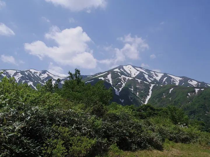
Mount Iide is the principal peak of the Iide range at 2,105 m, in Bandai-Asahi National Park. While the summit lies within Yamato, Kitakata City in Fukushima, the surrounding ridgeline forms the boundary between Yamagata, Fukushima, and Niigata, and six peaks above 2,000 m are linked by a 20-kilometer main crest. Long revered as a sacred mountain — historically the rite-of-passage pilgrimage of Aizu boys — the summit hosts the Iidesan Shrine inner sanctuary. Listed in the Hyakumeizan, the range is renowned for the endemic Iide Gentian and for its persistent snow patches. Approaches from Kawairi (Misawa Camp), Dainichisugi, and Yahirashirō are all long routes that typically require one or two nights in ridge huts.
Mount Iide at a glance
- Weather: The most settled day in the next 7 days is Wed, November 4: clear, gusts up to 6 m/s. Fri, Nov 6, Sat, Nov 7: strong wind (gusts up to 22 m/s).
- Route: The shortest is Mount Iide from the Oisawa Trailhead: about 14 h 5 min, 22.0 km, about 2,130 m of climbing.
Mount Iide weather (hourly, 14 days)
Sunrise today 06:08, sunset 16:42
| Tue, 11/3 | Wed, 11/4 | Thu, 11/5 | Fri, 11/6 | Sat, 11/7 | Sun, 11/8 | Mon, 11/9 | Tue, 11/10 | Wed, 11/11 | Thu, 11/12 | Fri, 11/13 | Sat, 11/14 | Sun, 11/15 | Mon, 11/16 | Tue, 11/17 | |||||||||||||||||||||||||||||||||||||||||||||||||||||||||||||||||||||||
|---|---|---|---|---|---|---|---|---|---|---|---|---|---|---|---|---|---|---|---|---|---|---|---|---|---|---|---|---|---|---|---|---|---|---|---|---|---|---|---|---|---|---|---|---|---|---|---|---|---|---|---|---|---|---|---|---|---|---|---|---|---|---|---|---|---|---|---|---|---|---|---|---|---|---|---|---|---|---|---|---|---|---|---|---|---|
| Japan time | 15 | 17 | 19 | 21 | 23 | 1 | 3 | 5 | 7 | 9 | 11 | 13 | 15 | 18 | 21 | 0 | 3 | 6 | 9 | 12 | 15 | 18 | 21 | 0 | 3 | 6 | 9 | 12 | 15 | 18 | 21 | 0 | 3 | 6 | 9 | 12 | 15 | 18 | 21 | 0 | 3 | 6 | 9 | 12 | 15 | 18 | 21 | 0 | 3 | 6 | 9 | 15 | 21 | 3 | 9 | 15 | 21 | 3 | 9 | 15 | 21 | 3 | 9 | 15 | 21 | 3 | 9 | 15 | 21 | 3 | 9 | 15 | 21 | 3 | 9 | 15 | 21 | 3 | 9 | 15 | 21 | 3 | 9 | 15 | |
  |  |   |   | | | | |  | | | | | | |   |   | |   | | | | |   | | | | | | | |   | | |   | | |   | | | | | | |   | | | | | | |   | | | | | | | | | | | | |   | | | | |   | | |  | | |   | | | | | | | | | ||
| Temperature | °C | 0° | -4° | -6° | -6° | -6° | -6° | -6° | -6° | -4° | 1° | 3° | 4° | 3° | -1° | -1° | 0° | 0° | 2° | 2° | 3° | 5° | 3° | 3° | 3° | 3° | 3° | 4° | 4° | 3° | 1° | -1° | -4° | -5° | -6° | -6° | -6° | -7° | -8° | -8° | -8° | -8° | -8° | -5° | -5° | -6° | -7° | -7° | -7° | -7° | -8° | -5° | -4° | -9° | -11° | -3° | 0° | -5° | -6° | -5° | -4° | -6° | -7° | -3° | -3° | -6° | -5° | -5° | -5° | -7° | -8° | -3° | 0° | -5° | -4° | 2° | 2° | -1° | 1° | 2° | -2° | -7° | -8° | -5° | -3° |
| Precipitation | mm | 2.9 | 13 | 2.8 | 3.0 | 0.2 | 0.3 | 1.8 | 2.0 | 2.7 | 3.5 | 1.2 | 3.2 | 2.5 | 3.4 | 3.8 | 4.4 | 3.8 | 2.3 | 1.7 | 1.2 | 0.4 | 0.7 | 0.3 | 0.3 | 1.1 | 2.5 | 2.4 | 1.5 | 0.2 | 0.2 | 0.9 | 1.4 | 1.7 | 9 | 3.9 | 2.2 | 3.7 | 2.2 | 0.6 | 0.2 | 3.0 | 4.6 | 0.8 | 0.8 | 0.1 | 4.2 | 8 | 4.4 | 8 | 6 | 0.9 | 0.2 | ||||||||||||||||||||||||||||||||
| New snow | cm | 0.4 | 2.0 | 3.2 | 3.4 | 2.0 | 1.7 | 1.2 | 0.4 | 0.7 | 0.3 | 0.3 | 1.0 | 2.1 | 1.8 | 1.2 | 0.2 | 0.1 | 0.8 | 1.4 | <.1 | 0.5 | 3.6 | 3.8 | 1.0 | 2.0 | 1.4 | 1.0 | 0.3 | 0.6 | 0.8 | <.1 | 1.4 | 0.7 | <.1 | ||||||||||||||||||||||||||||||||||||||||||||||||||
| Snow depth | cm | 0 | 0 | 0 | 0 | 0 | 0 | 0 | 0 | 0 | 0 | 0 | 0 | 0 | 0 | 0 | 0 | 0 | 0 | 0 | 0 | 0 | 0 | 0 | 0 | 0 | 0 | 0 | 0 | 0 | 0 | 0 | 0 | 1 | 3 | 5 | 5 | 6 | 7 | 7 | 7 | 7 | 7 | 8 | 8 | 9 | 9 | 9 | 9 | 9 | 10 | 10 | 8 | 7 | 7 | 7 | 6 | 6 | 8 | 10 | 8 | 9 | 9 | 9 | 7 | 7 | 7 | 7 | 7 | 7 | 7 | 7 | 6 | 6 | 6 | 5 | 3 | 3 | 2 | 2 | <1 | 1 | 2 | 2 | 1 |
| Wind | m/s | 3 | 1 | 1 | 1 | 1 | 1 | 1 | 1 | 1 | 1 | 1 | 1 | 2 | 2 | 3 | 3 | 3 | 1 | 1 | 1 | 1 | 1 | 2 | 1 | 2 | 2 | 3 | 4 | 3 | 3 | 3 | 2 | 2 | 2 | 3 | 4 | 4 | 3 | 3 | 2 | 3 | 3 | 4 | 3 | 2 | 1 | 1 | 1 | 1 | 1 | 1 | 1 | 1 | 1 | 1 | 2 | 2 | 2 | 3 | 4 | 2 | 1 | 2 | 2 | 1 | 2 | 4 | 5 | 2 | 1 | 1 | 0 | 1 | 1 | 1 | 0 | 2 | 1 | 1 | 5 | 3 | 2 | 2 | 1 |
| Wind gusts | m/s | 14 | 11 | 8 | 7 | 7 | 6 | 6 | 6 | 6 | 5 | 5 | 5 | 6 | 9 | 12 | 14 | 13 | 12 | 8 | 8 | 8 | 8 | 8 | 8 | 9 | 11 | 15 | 18 | 17 | 15 | 14 | 13 | 13 | 14 | 16 | 21 | 22 | 17 | 15 | 14 | 14 | 14 | 15 | 15 | 13 | 11 | 9 | 8 | 8 | 7 | 6 | 7 | 7 | 6 | 6 | 10 | 13 | 13 | 15 | 18 | 18 | 11 | 8 | 9 | 8 | 11 | 15 | 17 | 17 | 11 | 8 | 7 | 6 | 7 | 8 | 7 | 10 | 10 | 10 | 18 | 20 | 15 | 11 | 6 |
| Wind dir. | ↓ | ↓ | ↓ | ↓ | ↓ | ↓ | ↓ | ↓ | ↓ | ↓ | ↓ | ↓ | ↓ | ↓ | ↓ | ↓ | ↓ | ↓ | ↓ | ↓ | ↓ | ↓ | ↓ | ↓ | ↓ | ↓ | ↓ | ↓ | ↓ | ↓ | ↓ | ↓ | ↓ | ↓ | ↓ | ↓ | ↓ | ↓ | ↓ | ↓ | ↓ | ↓ | ↓ | ↓ | ↓ | ↓ | ↓ | ↓ | ↓ | ↓ | ↓ | ↓ | ↓ | ↓ | ↓ | ↓ | ↓ | ↓ | ↓ | ↓ | ↓ | ↓ | ↓ | ↓ | ↓ | ↓ | ↓ | ↓ | ↓ | ↓ | ↓ | ↓ | ↓ | ↓ | ↓ | ↓ | ↓ | ↓ | ↓ | ↓ | ↓ | ↓ | ↓ | ↓ | |
Mount Iide hiking routes
Hiking times are estimates calculated from the terrain.
Huts, campsites and lodging near Mount Iide
Mountain huts
Lists that include Mount Iide
100 Famous Japanese Mountains · Japan 200 Famous Mountains · Japan's 300 Famous Mountains · 100 Famous Mountains with First-order Triangulation Points · 100 Famous Hot Spring Mountains · Tohoku 100 Famous Mountains · Yamagata 100 Famous Mountains · Niigata 100 Famous Mountains · Utsukushima 100 Famous Mountains (Fukushima Prefecture) · Aizu 100 Famous Mountains · 30 Peaks of Fukushima · Elevations of 1003 Mountains of Japan · 1000 Mountains of Japan
Mount Iide facts
- Also known as
- 飯豊本山
- Elevation
- 2,105 m
- Location
- Kitakata, Fukushima
37.854860, 139.707121 - National Park
- 磐梯朝日国立公園
- Website
- www.city.kitakata.fukushima.jp
- Trail Map
- www.iikanjini.com
- Access Information
- www.city.kitakata.fukushima.jp
- Wikipedia
- ja.wikipedia.org