
Mount Himekami
姫神山
Morioka, Iwate · Elevation 1,123 m
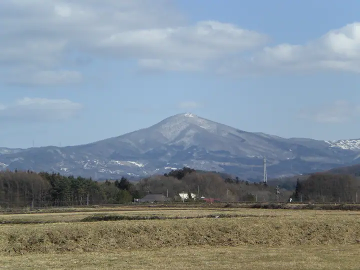
Mount Himekami is a 1,123.8 m peak in the Tamayama district of Morioka City, Iwate Prefecture, and one of the "Three Sacred Peaks of Northern Ōu" alongside Mount Iwate and Mount Hayachine. Traditionally venerated as the female counterpart (himekami, "princess deity") to the masculine Mount Iwate, it is included in the Nihon Nihyaku Meizan, the New Hana no Hyakumeizan, the Tōhoku Hyakumeizan, and the Nihon Hyaku-teizan (100 Low Mountains). Four trails climb to the summit—Ippon-sugi, Kowasaka, Tashiro, and Jōnai—each taking about an hour and a half; the giant cedar that gives the Ippon-sugi trailhead its name is so wide that four adults together cannot encircle it. The Morioka Tourism and Convention Association hosts the official mountain opening in mid-May, and the practical climbing season runs from May to November.
Mount Himekami at a glance
- Weather: The most settled day in the next 7 days is Wed, November 4: clear, gusts up to 9 m/s. Sat, Nov 7: strong wind (gusts up to 17 m/s).
- Route: The shortest is Mount Himekami Jonai Course Out-and-Back: about 3 h 17 min, 4.7 km, about 600 m of climbing.
Mount Himekami weather (hourly, 14 days)
Sunrise today 06:05, sunset 16:32
| Tue, 11/3 | Wed, 11/4 | Thu, 11/5 | Fri, 11/6 | Sat, 11/7 | Sun, 11/8 | Mon, 11/9 | Tue, 11/10 | Wed, 11/11 | Thu, 11/12 | Fri, 11/13 | Sat, 11/14 | Sun, 11/15 | Mon, 11/16 | Tue, 11/17 | |||||||||||||||||||||||||||||||||||||||||||||||||||||||||||||||||||||||
|---|---|---|---|---|---|---|---|---|---|---|---|---|---|---|---|---|---|---|---|---|---|---|---|---|---|---|---|---|---|---|---|---|---|---|---|---|---|---|---|---|---|---|---|---|---|---|---|---|---|---|---|---|---|---|---|---|---|---|---|---|---|---|---|---|---|---|---|---|---|---|---|---|---|---|---|---|---|---|---|---|---|---|---|---|---|
| Japan time | 15 | 17 | 19 | 21 | 23 | 1 | 3 | 5 | 7 | 9 | 11 | 13 | 15 | 18 | 21 | 0 | 3 | 6 | 9 | 12 | 15 | 18 | 21 | 0 | 3 | 6 | 9 | 12 | 15 | 18 | 21 | 0 | 3 | 6 | 9 | 12 | 15 | 18 | 21 | 0 | 3 | 6 | 9 | 12 | 15 | 18 | 21 | 0 | 3 | 6 | 9 | 15 | 21 | 3 | 9 | 15 | 21 | 3 | 9 | 15 | 21 | 3 | 9 | 15 | 21 | 3 | 9 | 15 | 21 | 3 | 9 | 15 | 21 | 3 | 9 | 15 | 21 | 3 | 9 | 15 | 21 | 3 | 9 | 15 | |
  |  |   | | | | | |   |  | | | | | | |   |   |   | | | | | |   |   |   |   | |   | | | | |   |   | |   | | | | | | | | | | | |   | | | | | | | |   |   | | | | | | | | | | |   | | |  | | | | | | | |   | | | | ||
| Temperature | °C | 6° | 2° | 0° | 0° | -1° | 0° | 0° | 1° | 1° | 5° | 8° | 10° | 9° | 3° | 3° | 3° | 3° | 4° | 6° | 7° | 8° | 7° | 7° | 7° | 7° | 7° | 9° | 10° | 9° | 7° | 4° | 1° | 1° | 0° | 0° | 1° | 0° | -1° | -1° | 0° | 0° | 0° | 1° | 3° | 1° | -1° | -2° | -1° | -1° | -3° | 2° | 3° | -2° | -4° | -1° | 4° | 0° | 1° | -2° | -1° | -2° | -4° | 0° | 3° | 0° | 0° | -1° | 1° | -4° | -5° | -1° | 4° | -2° | -3° | 4° | 7° | 3° | 3° | 5° | 2° | -3° | -5° | -1° | 3° |
| Precipitation | mm | 0.6 | 3.2 | 3.9 | 1.4 | 1.2 | 1.4 | 1.0 | 1.3 | 0.5 | 0.6 | 0.2 | 0.2 | 0.8 | 3.2 | 0.6 | 0.2 | 6 | 7 | 4.5 | 0.1 | 1.6 | 0.3 | 0.2 | 1.8 | 1.9 | 1.1 | 1.0 | |||||||||||||||||||||||||||||||||||||||||||||||||||||||||
| New snow | cm | <.1 | 0.6 | 2.9 | 0.2 | <.1 | <.1 | <.1 | <.1 | <.1 | <.1 | 1.4 | 2.0 | <.1 | <.1 | <.1 | <.1 | <.1 | |||||||||||||||||||||||||||||||||||||||||||||||||||||||||||||||||||
| Snow depth | cm | 0 | 0 | 0 | 0 | 0 | 0 | 0 | 0 | 0 | 0 | 0 | 0 | 0 | 0 | 0 | 0 | 0 | 0 | 0 | 0 | 0 | 0 | 0 | 0 | 0 | 0 | 0 | 0 | 0 | 0 | 0 | 0 | 0 | 0 | <1 | 2 | 1 | 1 | 1 | <1 | <1 | <1 | <1 | 0 | 0 | 0 | 0 | 0 | 0 | 0 | 0 | 0 | 0 | 0 | 0 | 0 | 0 | 0 | <1 | 1 | 1 | 1 | <1 | <1 | <1 | <1 | <1 | <1 | <1 | <1 | <1 | <1 | <1 | <1 | <1 | 0 | 0 | 0 | 0 | 0 | 0 | 0 | 0 | 0 |
| Wind | m/s | 4 | 2 | 1 | 2 | 3 | 4 | 4 | 4 | 3 | 3 | 2 | 1 | 2 | 3 | 3 | 3 | 3 | 4 | 4 | 1 | 1 | 1 | 1 | 3 | 2 | 3 | 3 | 4 | 4 | 1 | 3 | 2 | 3 | 4 | 4 | 5 | 5 | 4 | 4 | 4 | 4 | 4 | 4 | 5 | 4 | 2 | 3 | 2 | 2 | 1 | 2 | 2 | 1 | 2 | 1 | 3 | 2 | 0 | 6 | 5 | 2 | 1 | 2 | 3 | 3 | 1 | 4 | 5 | 2 | 1 | 0 | 0 | 2 | 1 | 2 | 3 | 3 | 2 | 1 | 4 | 4 | 2 | 2 | 1 |
| Wind gusts | m/s | 12 | 11 | 5 | 5 | 6 | 8 | 9 | 9 | 9 | 8 | 8 | 6 | 6 | 6 | 6 | 8 | 8 | 11 | 10 | 10 | 4 | 3 | 4 | 7 | 7 | 6 | 8 | 12 | 13 | 11 | 7 | 9 | 8 | 10 | 14 | 17 | 17 | 14 | 12 | 12 | 12 | 10 | 12 | 14 | 14 | 10 | 6 | 6 | 6 | 5 | 5 | 8 | 7 | 4 | 4 | 7 | 11 | 9 | 13 | 18 | 13 | 4 | 6 | 8 | 9 | 8 | 11 | 12 | 11 | 7 | 5 | 5 | 4 | 5 | 5 | 9 | 9 | 9 | 7 | 15 | 12 | 9 | 6 | 7 |
| Wind dir. | ↓ | ↓ | ↓ | ↓ | ↓ | ↓ | ↓ | ↓ | ↓ | ↓ | ↓ | ↓ | ↓ | ↓ | ↓ | ↓ | ↓ | ↓ | ↓ | ↓ | ↓ | ↓ | ↓ | ↓ | ↓ | ↓ | ↓ | ↓ | ↓ | ↓ | ↓ | ↓ | ↓ | ↓ | ↓ | ↓ | ↓ | ↓ | ↓ | ↓ | ↓ | ↓ | ↓ | ↓ | ↓ | ↓ | ↓ | ↓ | ↓ | ↓ | ↓ | ↓ | ↓ | ↓ | ↓ | ↓ | ↓ | ↓ | ↓ | ↓ | ↓ | ↓ | ↓ | ↓ | ↓ | ↓ | ↓ | ↓ | ↓ | ↓ | ↓ | ↓ | ↓ | ↓ | ↓ | ↓ | ↓ | ↓ | ↓ | ↓ | ↓ | ↓ | ↓ | ↓ | |
Mount Himekami hiking routes
- Mount Himekami Jonai Course Out-and-Back 4.7 km · Ascent 603 m 城内登山口 (parking)
- Mount Himekami Circuit from Ipponsugi Trailhead via Kowasaka 5.8 km · Ascent 613 m 一本杉登山口 (parking)
Hiking times are estimates calculated from the terrain.
Huts, campsites and lodging near Mount Himekami
Campsites
- 姫神山一本杉園地キャンプ場
Lists that include Mount Himekami
Japan 200 Famous Mountains · Japan's 300 Famous Mountains · New 100 Famous Flower Mountains · 100 Low Mountains of Japan · Illustrated Collection of Japan's Famous Mountains · Tohoku 100 Famous Mountains · Iwate 100 Famous Mountains · Elevations of 1003 Mountains of Japan · 1000 Mountains of Japan
Mount Himekami facts
- Elevation
- 1,123 m
- Location
- Morioka, Iwate
39.843888, 141.246908 - Website
- www.rinya.maff.go.jp
- Trail Map
- www.city.morioka.iwate.jp (PDF)
- Access Information
- www.city.morioka.iwate.jp
- Wikipedia
- ja.wikipedia.org