
Mount Futamata
二岐山
Ten-ei, Fukushima · Elevation 1,544 m
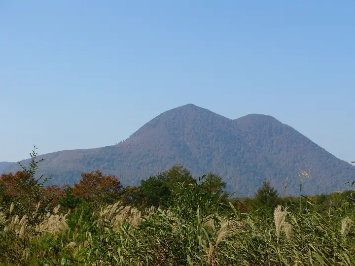
Mount Futamata is a 1,544 m twin-peaked mountain straddling Tenei Village in Iwase District and Shimogō Town in Minamiaizu District, Fukushima Prefecture, made up of the male peak (Otoko-dake, 1,544 m) and the female peak (Onna-dake, 1,504 m). It is listed in the Nihon Sanbyaku Meizan, the Tōhoku 100 Meizan, the Utsukushima 100 Meizan, the Aizu Hyakumeizan, the Onsen Hyakumeizan, the Nihon Meizan Zukai, and the Fukushima 30 Mountains. The mountain lies within Ōkawa-Habuto Prefectural Natural Park, and the wooded slopes hold Onabe-jinja shrine, beside which a 520-year-old Sawara cypress towers. The standard ascent loops from Futamata Onsen — a hot-spring village with a 1,200-year history said to be the birthplace of the Japanese word "hitō" (secret hot spring) — climbing the Onna-dake (Wind-Farm) trailhead to the female peak, then on to the male peak before descending via the Onabe trailhead and Ko-Shiroshi-mori trailhead.
Mount Futamata at a glance
- Weather: The most settled day in the next 7 days is Wed, November 4: clear, gusts up to 9 m/s. Fri, Nov 6, Sat, Nov 7, Sun, Nov 8: strong wind (gusts up to 22 m/s).
Mount Futamata weather (hourly, 14 days)
Sunrise today 06:06, sunset 16:42
| Tue, 11/3 | Wed, 11/4 | Thu, 11/5 | Fri, 11/6 | Sat, 11/7 | Sun, 11/8 | Mon, 11/9 | Tue, 11/10 | Wed, 11/11 | Thu, 11/12 | Fri, 11/13 | Sat, 11/14 | Sun, 11/15 | Mon, 11/16 | Tue, 11/17 | |||||||||||||||||||||||||||||||||||||||||||||||||||||||||||||||||||||||
|---|---|---|---|---|---|---|---|---|---|---|---|---|---|---|---|---|---|---|---|---|---|---|---|---|---|---|---|---|---|---|---|---|---|---|---|---|---|---|---|---|---|---|---|---|---|---|---|---|---|---|---|---|---|---|---|---|---|---|---|---|---|---|---|---|---|---|---|---|---|---|---|---|---|---|---|---|---|---|---|---|---|---|---|---|---|
| Japan time | 15 | 17 | 19 | 21 | 23 | 1 | 3 | 5 | 7 | 9 | 11 | 13 | 15 | 18 | 21 | 0 | 3 | 6 | 9 | 12 | 15 | 18 | 21 | 0 | 3 | 6 | 9 | 12 | 15 | 18 | 21 | 0 | 3 | 6 | 9 | 12 | 15 | 18 | 21 | 0 | 3 | 6 | 9 | 12 | 15 | 18 | 21 | 0 | 3 | 6 | 9 | 15 | 21 | 3 | 9 | 15 | 21 | 3 | 9 | 15 | 21 | 3 | 9 | 15 | 21 | 3 | 9 | 15 | 21 | 3 | 9 | 15 | 21 | 3 | 9 | 15 | 21 | 3 | 9 | 15 | 21 | 3 | 9 | 15 | |
  |   | |  | | | | | |  | | | |   |   | | | |   | |   |   | | | | |   | |   | | | | | |   | |   |   | | | | | | | | | | | | |   | | | | | | | | | | | | | |  | | | | | | | | | | | | |   | | | |   | | | ||
| Temperature | °C | 4° | 1° | -1° | -2° | -2° | -3° | -3° | -3° | -1° | 4° | 7° | 8° | 6° | 1° | 1° | 1° | 2° | 3° | 5° | 7° | 8° | 5° | 5° | 5° | 2° | 4° | 7° | 9° | 8° | 5° | 3° | 1° | 0° | -2° | -3° | -3° | -3° | -4° | -3° | -4° | -4° | -4° | -2° | 0° | -1° | -2° | -3° | -2° | -3° | -3° | -2° | 2° | -3° | -4° | 1° | 3° | -3° | -3° | -2° | -1° | -2° | -3° | -1° | 2° | -4° | -2° | -1° | -2° | -4° | -5° | 0° | 4° | -5° | -4° | 6° | 7° | 3° | 3° | 8° | 2° | -3° | -5° | -2° | 1° |
| Precipitation | mm | 1.5 | 2.3 | 7 | 9 | 7 | 1.7 | 0.2 | 1.3 | 0.3 | 0.5 | 1.2 | 1.1 | 0.6 | 1.4 | 2.4 | 2.4 | 1.4 | 0.9 | 0.8 | 0.5 | 0.5 | 0.5 | 0.6 | 0.1 | 0.4 | 0.2 | 1.2 | 1.3 | 2.2 | 0.8 | 0.5 | 0.2 | 0.3 | 2.5 | 0.2 | 2.8 | 8 | 3.7 | 2.4 | 0.3 | ||||||||||||||||||||||||||||||||||||||||||||
| New snow | cm | 1.0 | 1.5 | 0.5 | 0.4 | 0.5 | 0.2 | 0.2 | 0.2 | 0.1 | 0.9 | 0.1 | 0.2 | ||||||||||||||||||||||||||||||||||||||||||||||||||||||||||||||||||||||||
| Snow depth | cm | 0 | 0 | 0 | 0 | 0 | 0 | 0 | 0 | 0 | 0 | 0 | 0 | 0 | 0 | 0 | 0 | 0 | 0 | 0 | 0 | 0 | 0 | 0 | 0 | 0 | 0 | 0 | 0 | 0 | 0 | 0 | 0 | 0 | 0 | <1 | 1 | <1 | <1 | 1 | 1 | 1 | 1 | <1 | <1 | <1 | 0 | 0 | 0 | 0 | 0 | 0 | 0 | 0 | 0 | 0 | 0 | 0 | 0 | <1 | 0 | 0 | 0 | 0 | 0 | 0 | 0 | 0 | 0 | 0 | 0 | 0 | 0 | 0 | 0 | 0 | 0 | 0 | 0 | 0 | 0 | 0 | 0 | 0 | 0 |
| Wind | m/s | 5 | 3 | 2 | 2 | 2 | 2 | 2 | 2 | 2 | 1 | 1 | 2 | 3 | 2 | 2 | 2 | 2 | 1 | 2 | 1 | 1 | 1 | 1 | 1 | 1 | 2 | 6 | 7 | 6 | 4 | 3 | 4 | 6 | 5 | 4 | 6 | 6 | 6 | 6 | 6 | 5 | 5 | 5 | 7 | 6 | 3 | 2 | 2 | 2 | 2 | 1 | 2 | 2 | 1 | 1 | 5 | 2 | 5 | 7 | 7 | 5 | 4 | 4 | 4 | 1 | 3 | 7 | 7 | 5 | 3 | 2 | 1 | 1 | 0 | 1 | 0 | 1 | 1 | 2 | 6 | 8 | 5 | 3 | 2 |
| Wind gusts | m/s | 17 | 15 | 9 | 8 | 7 | 7 | 7 | 6 | 6 | 6 | 5 | 6 | 9 | 10 | 8 | 9 | 8 | 6 | 8 | 7 | 5 | 4 | 4 | 5 | 5 | 9 | 17 | 20 | 20 | 17 | 14 | 13 | 17 | 18 | 16 | 20 | 22 | 20 | 18 | 19 | 17 | 18 | 16 | 19 | 20 | 18 | 10 | 7 | 6 | 6 | 6 | 7 | 7 | 5 | 4 | 12 | 12 | 13 | 21 | 25 | 22 | 15 | 11 | 12 | 11 | 9 | 18 | 21 | 20 | 14 | 9 | 7 | 5 | 4 | 3 | 5 | 5 | 7 | 8 | 18 | 22 | 22 | 13 | 7 |
| Wind dir. | ↓ | ↓ | ↓ | ↓ | ↓ | ↓ | ↓ | ↓ | ↓ | ↓ | ↓ | ↓ | ↓ | ↓ | ↓ | ↓ | ↓ | ↓ | ↓ | ↓ | ↓ | ↓ | ↓ | ↓ | ↓ | ↓ | ↓ | ↓ | ↓ | ↓ | ↓ | ↓ | ↓ | ↓ | ↓ | ↓ | ↓ | ↓ | ↓ | ↓ | ↓ | ↓ | ↓ | ↓ | ↓ | ↓ | ↓ | ↓ | ↓ | ↓ | ↓ | ↓ | ↓ | ↓ | ↓ | ↓ | ↓ | ↓ | ↓ | ↓ | ↓ | ↓ | ↓ | ↓ | ↓ | ↓ | ↓ | ↓ | ↓ | ↓ | ↓ | ↓ | ↓ | ↓ | ↓ | ↓ | ↓ | ↓ | ↓ | ↓ | ↓ | ↓ | ↓ | ↓ | |
Huts, campsites and lodging near Mount Futamata
Lodging
- 二岐温泉 旅館ふじや
- 二岐温泉 やすらぎの宿 桂祗荘
- 二岐温泉 柏屋旅館
- 二岐温泉 湯小屋旅館
- 二岐温泉 大丸あすなろ荘
Lists that include Mount Futamata
Japan's 300 Famous Mountains · Illustrated Collection of Japan's Famous Mountains · 100 Famous Hot Spring Mountains · Tohoku 100 Famous Mountains · Utsukushima 100 Famous Mountains (Fukushima Prefecture) · Aizu 100 Famous Mountains · 30 Peaks of Fukushima · 1000 Mountains of Japan
Mount Futamata facts
- Also known as
- 二岐山男岳
- Elevation
- 1,544 m
- Location
- Ten-ei, Fukushima
37.246421, 139.967355 - Website
- www.tif.ne.jp
- Trail Map
- www.vill.tenei.fukushima.jp (PDF)
- Access Information
- www.tif.ne.jp
- Wikipedia
- ja.wikipedia.org