
Mount Furano-nishi
富良野西岳
Furano, Hokkaido · Elevation 1,331 m
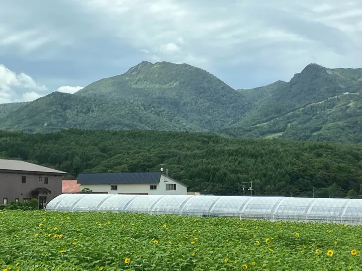
Mount Furano-nishi is a 1,330.9 m peak in Furano City, Hokkaido, standing on the main ridge of the northern Yūbari Range. Its summit carries the first-class triangulation point 'Shimo-furano', and the sharp profile with a cliff on the south-east face is conspicuous from the Furano basin. Three trails climb the mountain — an old stream-side route, a course starting from the upper station of the Furano Ropeway, and a route up the Furano Ski Area's World Cup downhill piste — each about 3.5 hours to the top. The summit overlooks the Furano basin and the Tokachi and Daisetsu ranges. It is one of the 100 Famous Mountains of Hokkaido.
Mount Furano-nishi at a glance
- Weather: The most settled day in the next 7 days is Thu, November 5: clear, gusts up to 9 m/s. Sat, Nov 7, Sun, Nov 8: strong wind (gusts up to 18 m/s).
Mount Furano-nishi weather (hourly, 14 days)
Sunrise today 06:07, sunset 16:21
| Tue, 11/3 | Wed, 11/4 | Thu, 11/5 | Fri, 11/6 | Sat, 11/7 | Sun, 11/8 | Mon, 11/9 | Tue, 11/10 | Wed, 11/11 | Thu, 11/12 | Fri, 11/13 | Sat, 11/14 | Sun, 11/15 | Mon, 11/16 | Tue, 11/17 | |||||||||||||||||||||||||||||||||||||||||||||||||||||||||||||||||||||||
|---|---|---|---|---|---|---|---|---|---|---|---|---|---|---|---|---|---|---|---|---|---|---|---|---|---|---|---|---|---|---|---|---|---|---|---|---|---|---|---|---|---|---|---|---|---|---|---|---|---|---|---|---|---|---|---|---|---|---|---|---|---|---|---|---|---|---|---|---|---|---|---|---|---|---|---|---|---|---|---|---|---|---|---|---|---|
| Japan time | 15 | 17 | 19 | 21 | 23 | 1 | 3 | 5 | 7 | 9 | 11 | 13 | 15 | 18 | 21 | 0 | 3 | 6 | 9 | 12 | 15 | 18 | 21 | 0 | 3 | 6 | 9 | 12 | 15 | 18 | 21 | 0 | 3 | 6 | 9 | 12 | 15 | 18 | 21 | 0 | 3 | 6 | 9 | 12 | 15 | 18 | 21 | 0 | 3 | 6 | 9 | 15 | 21 | 3 | 9 | 15 | 21 | 3 | 9 | 15 | 21 | 3 | 9 | 15 | 21 | 3 | 9 | 15 | 21 | 3 | 9 | 15 | 21 | 3 | 9 | 15 | 21 | 3 | 9 | 15 | 21 | 3 | 9 | 15 | |
  |  |   |   |   |   | | | |   | | |  |  | | | |   | | | |   | |   | | |   | |   |   | |   | | |   |   | | | | | | | | | | | | | | |   | | | |   | | | | | | | | | | | | | | | | | |  | | | | | | |   | | | | | ||
| Temperature | °C | -2° | -5° | -7° | -5° | -6° | -6° | -5° | -5° | -4° | -3° | -2° | -1° | -1° | -7° | -8° | -7° | -7° | -6° | 2° | 6° | 6° | 1° | 0° | -1° | 0° | 0° | 2° | 5° | 6° | 0° | -2° | -6° | -7° | -7° | -6° | -6° | -7° | -8° | -8° | -8° | -8° | -8° | -7° | -7° | -7° | -7° | -8° | -8° | -9° | -8° | -7° | -7° | -10° | -9° | -7° | -6° | -12° | -9° | -6° | -5° | -12° | -10° | -5° | -5° | -7° | -9° | -9° | -7° | -9° | -15° | -8° | -4° | -11° | -9° | -1° | -1° | -3° | -3° | -4° | -5° | -8° | -8° | -6° | -5° |
| Precipitation | mm | 0.9 | 1.7 | 0.2 | 4.6 | 2.7 | 1.5 | 3.5 | 0.6 | 0.3 | 1.9 | 0.9 | 0.2 | 0.2 | 0.2 | 1.1 | 1.6 | 1.2 | 1.7 | 1.2 | 1.7 | 1.8 | 1.1 | 0.8 | 0.6 | 0.2 | 0.1 | 0.3 | 0.2 | 0.7 | 1.7 | 0.2 | 0.3 | 0.2 | 0.4 | 0.6 | 0.3 | 0.8 | 0.8 | 1.3 | 2.6 | 4.1 | 0.1 | ||||||||||||||||||||||||||||||||||||||||||
| New snow | cm | <.1 | <.1 | 0.9 | 1.7 | <.1 | 0.4 | 0.3 | 0.2 | 0.2 | 1.1 | 1.6 | 1.2 | 1.7 | 1.2 | 1.7 | 1.8 | 1.1 | 0.8 | 0.6 | 0.2 | <.1 | <.1 | <.1 | <.1 | <.1 | 0.1 | 0.3 | 0.2 | 0.7 | 1.7 | 0.2 | 0.2 | 0.2 | 0.4 | 0.6 | 0.3 | 0.8 | 1.4 | <.1 | <.1 | <.1 | |||||||||||||||||||||||||||||||||||||||||||
| Snow depth | cm | 0 | 0 | 0 | 0 | <1 | <1 | 2 | 2 | 2 | 1 | 1 | <1 | <1 | <1 | <1 | <1 | <1 | <1 | <1 | <1 | 0 | 0 | 0 | 0 | 0 | 0 | 0 | 0 | 0 | 0 | 0 | 0 | <1 | <1 | <1 | 1 | 2 | 3 | 4 | 5 | 5 | 6 | 7 | 7 | 7 | 7 | 7 | 7 | 7 | 7 | 7 | 7 | 7 | 7 | 7 | 6 | 6 | 7 | 8 | 8 | 8 | 8 | 8 | 7 | 8 | 8 | 8 | 8 | 9 | 9 | 8 | 8 | 8 | 8 | 8 | 5 | 4 | 2 | 2 | 3 | 3 | 3 | 3 | 3 |
| Wind | m/s | 5 | 3 | 2 | 2 | 2 | 3 | 2 | 2 | 4 | 5 | 4 | 4 | 2 | 1 | 2 | 2 | 2 | 2 | 3 | 4 | 2 | 1 | 2 | 1 | 2 | 2 | 3 | 2 | 4 | 5 | 4 | 6 | 5 | 5 | 7 | 6 | 5 | 5 | 6 | 6 | 6 | 6 | 6 | 6 | 4 | 4 | 3 | 2 | 2 | 2 | 3 | 3 | 2 | 1 | 1 | 1 | 1 | 1 | 1 | 0 | 1 | 1 | 1 | 3 | 2 | 2 | 4 | 4 | 2 | 1 | 0 | 1 | 1 | 2 | 2 | 2 | 2 | 2 | 2 | 3 | 3 | 2 | 2 | 1 |
| Wind gusts | m/s | 14 | 11 | 7 | 6 | 6 | 8 | 9 | 7 | 10 | 13 | 13 | 11 | 10 | 6 | 6 | 6 | 8 | 8 | 9 | 9 | 9 | 6 | 6 | 6 | 5 | 6 | 8 | 9 | 11 | 14 | 12 | 16 | 16 | 13 | 16 | 18 | 18 | 16 | 18 | 17 | 17 | 17 | 17 | 18 | 16 | 12 | 10 | 9 | 7 | 6 | 9 | 10 | 9 | 6 | 5 | 6 | 4 | 5 | 6 | 7 | 3 | 3 | 4 | 8 | 8 | 8 | 11 | 12 | 11 | 6 | 3 | 4 | 4 | 5 | 7 | 7 | 7 | 7 | 6 | 9 | 11 | 9 | 7 | 7 |
| Wind dir. | ↓ | ↓ | ↓ | ↓ | ↓ | ↓ | ↓ | ↓ | ↓ | ↓ | ↓ | ↓ | ↓ | ↓ | ↓ | ↓ | ↓ | ↓ | ↓ | ↓ | ↓ | ↓ | ↓ | ↓ | ↓ | ↓ | ↓ | ↓ | ↓ | ↓ | ↓ | ↓ | ↓ | ↓ | ↓ | ↓ | ↓ | ↓ | ↓ | ↓ | ↓ | ↓ | ↓ | ↓ | ↓ | ↓ | ↓ | ↓ | ↓ | ↓ | ↓ | ↓ | ↓ | ↓ | ↓ | ↓ | ↓ | ↓ | ↓ | ↓ | ↓ | ↓ | ↓ | ↓ | ↓ | ↓ | ↓ | ↓ | ↓ | ↓ | ↓ | ↓ | ↓ | ↓ | ↓ | ↓ | ↓ | ↓ | ↓ | ↓ | ↓ | ↓ | ↓ | ↓ | |
Huts, campsites and lodging near Mount Furano-nishi
Lodging
- 新富良野プリンスホテル
Lists that include Mount Furano-nishi
Hokkaido 100 Famous Mountains · Elevations of 1003 Mountains of Japan · 1000 Mountains of Japan
Mount Furano-nishi facts
- Elevation
- 1,331 m
- Location
- Furano, Hokkaido
43.309164, 142.311664 - Website
- www.furanotourism.com
- Trail Map
- www.furanotourism.com (PDF)
- Wikipedia
- ja.wikipedia.org