
Mount Ashibetsu
芦別岳
Furano, Hokkaido · Elevation 1,726 m
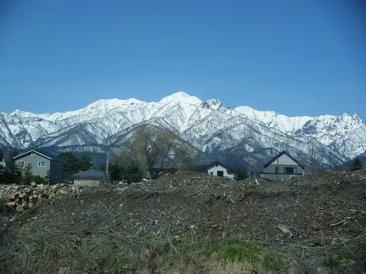
Mount Ashibetsu is a 1,726 m peak on the boundary between Furano, Ashibetsu, and Minamifurano in central Hokkaidō, the principal summit at the heart of the Yūbari Mountains. Listed in the Nihon Nihyaku Meizan and the Hokkaidō Hyakumeizan, it lies within Furano-Ashibetsu Prefectural Natural Park. The peak's sharp rocky ridges have earned it the nickname "Matterhorn of Hokkaidō"; Fukada Kyūya died before he could climb it, which is why the mountain became a Nihyaku Meizan rather than a Hyakumeizan. The principal route from the Taiyō-no-Sato campground in the Yamabe district of Furano takes about four-and-a-half hours via Hanmenzan and Unbōzan along the Shindō (new) trail, while the longer Kyūdō (old) trail requires roughly seven hours up the Yūfure-zawa and around the Meoto-iwa, making it a route for experienced climbers.
Mount Ashibetsu at a glance
- Weather: The most settled day in the next 7 days is Thu, November 5: cloudy, gusts up to 11 m/s. Wed, Nov 4, Fri, Nov 6, Sat, Nov 7, Sun, Nov 8: strong wind (gusts up to 22 m/s).
- Route: The shortest is Mount Ashibetsu via the Shindō Route: about 9 h 14 min, 13.9 km, about 1,510 m of climbing.
Mount Ashibetsu weather (hourly, 14 days)
Sunrise today 06:07, sunset 16:22
| Tue, 11/3 | Wed, 11/4 | Thu, 11/5 | Fri, 11/6 | Sat, 11/7 | Sun, 11/8 | Mon, 11/9 | Tue, 11/10 | Wed, 11/11 | Thu, 11/12 | Fri, 11/13 | Sat, 11/14 | Sun, 11/15 | Mon, 11/16 | Tue, 11/17 | |||||||||||||||||||||||||||||||||||||||||||||||||||||||||||||||||||||||
|---|---|---|---|---|---|---|---|---|---|---|---|---|---|---|---|---|---|---|---|---|---|---|---|---|---|---|---|---|---|---|---|---|---|---|---|---|---|---|---|---|---|---|---|---|---|---|---|---|---|---|---|---|---|---|---|---|---|---|---|---|---|---|---|---|---|---|---|---|---|---|---|---|---|---|---|---|---|---|---|---|---|---|---|---|---|
| Japan time | 15 | 17 | 19 | 21 | 23 | 1 | 3 | 5 | 7 | 9 | 11 | 13 | 15 | 18 | 21 | 0 | 3 | 6 | 9 | 12 | 15 | 18 | 21 | 0 | 3 | 6 | 9 | 12 | 15 | 18 | 21 | 0 | 3 | 6 | 9 | 12 | 15 | 18 | 21 | 0 | 3 | 6 | 9 | 12 | 15 | 18 | 21 | 0 | 3 | 6 | 9 | 15 | 21 | 3 | 9 | 15 | 21 | 3 | 9 | 15 | 21 | 3 | 9 | 15 | 21 | 3 | 9 | 15 | 21 | 3 | 9 | 15 | 21 | 3 | 9 | 15 | 21 | 3 | 9 | 15 | 21 | 3 | 9 | 15 | |
  |   |   |   |   | |   | |   | | |  | |  | | | | | |   |   | |   | | | |   | |   | | | | | |   | | | | | | | | | | | | | | | | | | | |   | |   | | | | | | | | | | | | | | | |  | | | | | |   | | | | | | ||
| Temperature | °C | -5° | -8° | -8° | -7° | -8° | -7° | -6° | -6° | -6° | -5° | -4° | -3° | -3° | -8° | -7° | -6° | -5° | -4° | 1° | 4° | 4° | 1° | 0° | 0° | 0° | 0° | 3° | 5° | 5° | -1° | -4° | -7° | -9° | -9° | -8° | -8° | -9° | -9° | -9° | -10° | -10° | -10° | -9° | -9° | -9° | -9° | -9° | -9° | -10° | -10° | -9° | -9° | -11° | -11° | -9° | -8° | -13° | -10° | -7° | -5° | -12° | -10° | -6° | -6° | -8° | -10° | -10° | -8° | -10° | -15° | -7° | -5° | -11° | -7° | 0° | -1° | -2° | -2° | -4° | -6° | -10° | -10° | -7° | -6° |
| Precipitation | mm | 0.4 | 1.2 | 2.1 | 0.1 | 0.2 | 0.2 | 0.6 | 5 | 1.9 | 1.0 | 4.0 | 0.6 | 0.4 | 2.6 | 0.4 | 2.2 | 1.0 | 0.5 | 0.3 | 0.8 | 2.2 | 2.4 | 3.0 | 2.1 | 2.4 | 3.6 | 3.4 | 2.3 | 1.6 | 1.2 | 0.9 | 0.3 | 0.2 | 0.3 | 0.6 | 1.2 | 1.9 | 0.2 | 0.8 | 0.6 | 0.6 | 0.2 | 0.2 | 0.4 | 0.4 | 1.9 | 2.4 | 2.9 | 4.0 | 0.5 | 0.2 | |||||||||||||||||||||||||||||||||
| New snow | cm | 0.4 | <.1 | 1.2 | 2.1 | <.1 | 0.2 | 0.2 | 0.3 | 2.0 | 1.0 | 0.5 | 0.3 | 0.8 | 2.2 | 2.4 | 3.0 | 2.1 | 2.4 | 3.6 | 3.4 | 2.3 | 1.6 | 1.2 | 0.9 | 0.3 | 0.2 | <.1 | <.1 | 0.3 | <.1 | 0.6 | <.1 | 1.2 | 1.9 | 0.2 | 0.8 | 0.6 | 0.5 | 0.2 | 0.2 | 0.5 | 0.4 | 3.7 | 0.5 | 0.2 | |||||||||||||||||||||||||||||||||||||||
| Snow depth | cm | 2 | 2 | 2 | 2 | 3 | 3 | 5 | 5 | 5 | 5 | 5 | 4 | 4 | 4 | 4 | 4 | 4 | 4 | 4 | 2 | 2 | <1 | <1 | <1 | <1 | <1 | 0 | 0 | 0 | 0 | 0 | 2 | 2 | 2 | 2 | 3 | 4 | 6 | 8 | 10 | 11 | 14 | 16 | 17 | 18 | 19 | 19 | 19 | 19 | 19 | 18 | 18 | 17 | 18 | 17 | 17 | 17 | 17 | 19 | 18 | 18 | 17 | 17 | 17 | 18 | 18 | 18 | 18 | 18 | 18 | 18 | 17 | 17 | 17 | 17 | 13 | 11 | 9 | 9 | 11 | 11 | 11 | 11 | 11 |
| Wind | m/s | 4 | 2 | 2 | 2 | 3 | 4 | 4 | 3 | 3 | 5 | 5 | 3 | 2 | 3 | 3 | 3 | 4 | 4 | 3 | 3 | 2 | 2 | 3 | 2 | 2 | 2 | 3 | 3 | 5 | 5 | 4 | 6 | 5 | 5 | 7 | 7 | 5 | 6 | 7 | 7 | 6 | 6 | 6 | 6 | 4 | 4 | 4 | 3 | 3 | 3 | 3 | 4 | 2 | 2 | 1 | 1 | 1 | 2 | 2 | 0 | 1 | 1 | 2 | 4 | 2 | 2 | 5 | 4 | 3 | 1 | 2 | 1 | 2 | 2 | 4 | 3 | 3 | 3 | 1 | 4 | 3 | 2 | 2 | 2 |
| Wind gusts | m/s | 15 | 13 | 8 | 8 | 9 | 13 | 14 | 13 | 12 | 16 | 15 | 14 | 10 | 8 | 10 | 11 | 12 | 12 | 11 | 10 | 10 | 7 | 7 | 7 | 7 | 7 | 10 | 12 | 16 | 17 | 15 | 17 | 18 | 16 | 21 | 22 | 21 | 19 | 20 | 22 | 21 | 19 | 18 | 21 | 19 | 14 | 11 | 11 | 10 | 9 | 10 | 11 | 11 | 7 | 6 | 6 | 4 | 7 | 9 | 8 | 4 | 6 | 8 | 11 | 11 | 9 | 13 | 13 | 13 | 10 | 6 | 7 | 5 | 6 | 11 | 11 | 11 | 10 | 9 | 12 | 13 | 10 | 8 | 8 |
| Wind dir. | ↓ | ↓ | ↓ | ↓ | ↓ | ↓ | ↓ | ↓ | ↓ | ↓ | ↓ | ↓ | ↓ | ↓ | ↓ | ↓ | ↓ | ↓ | ↓ | ↓ | ↓ | ↓ | ↓ | ↓ | ↓ | ↓ | ↓ | ↓ | ↓ | ↓ | ↓ | ↓ | ↓ | ↓ | ↓ | ↓ | ↓ | ↓ | ↓ | ↓ | ↓ | ↓ | ↓ | ↓ | ↓ | ↓ | ↓ | ↓ | ↓ | ↓ | ↓ | ↓ | ↓ | ↓ | ↓ | ↓ | ↓ | ↓ | ↓ | ↓ | ↓ | ↓ | ↓ | ↓ | ↓ | ↓ | ↓ | ↓ | ↓ | ↓ | ↓ | ↓ | ↓ | ↓ | ↓ | ↓ | ↓ | ↓ | ↓ | ↓ | ↓ | ↓ | ↓ | ↓ | |
Mount Ashibetsu hiking routes
Hiking times are estimates calculated from the terrain.
Huts, campsites and lodging near Mount Ashibetsu
Mountain huts
Campsites
- 山部自然公園太陽の里キャンプ場
Lists that include Mount Ashibetsu
Japan 200 Famous Mountains · Japan's 300 Famous Mountains · Hokkaido 100 Famous Mountains · Elevations of 1003 Mountains of Japan · 1000 Mountains of Japan
Mount Ashibetsu facts
- Elevation
- 1,726 m
- Location
- Furano, Hokkaido
43.235832, 142.283614 - Website
- www.furanotourism.com
- Wikipedia
- en.wikipedia.org