
Mount Akanfuji
阿寒富士
雌阿寒岳 レベル2(火口周辺規制) · issued September 15 at 15:20
Ashoro, Hokkaido / Shiranuka, Hokkaido · Elevation 1,476 m
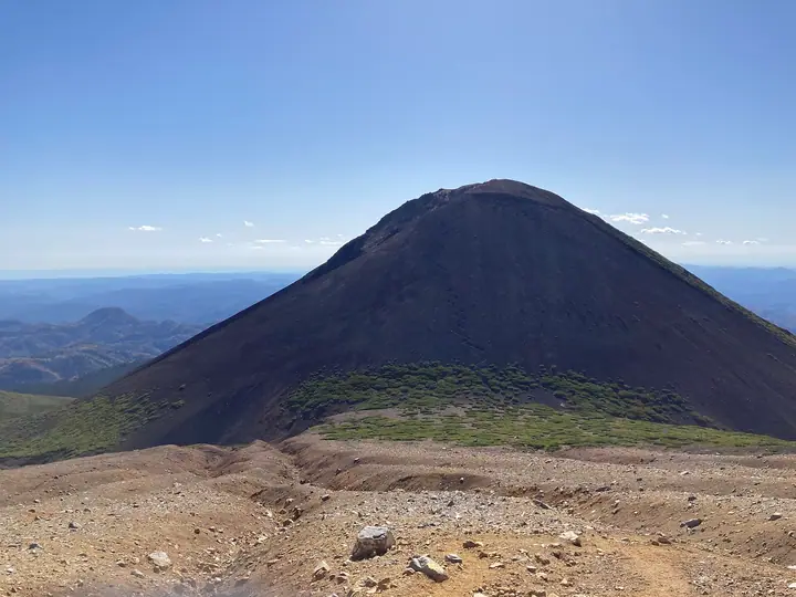
Mount Akanfuji is a 1,476 m stratovolcano in eastern Hokkaido, on the border between Shiranuka and Ashoro, forming part of the Akan volcanic complex. Built roughly 2,500–1,000 years ago from basaltic lava and pyroclastic deposits, its symmetrical cone earned it the “Fuji” name. It is a parasitic cone south of Meakan, within Akan-Mashu National Park. The usual round trip to its summit from the Onneto Trail junction takes 1.5 hours.
Mount Akanfuji at a glance
- Weather: The most settled day in the next 7 days is Mon, November 9: clear, gusts up to 8 m/s. Sat, Nov 7, Sun, Nov 8: strong wind (gusts up to 21 m/s).
- Route: The shortest is Mount Meakan, Mount Akan-Fuji and Lake Onneto Loop from Meakan Onsen: about 7 h 38 min, 12.2 km, about 1,140 m of climbing.
Mount Akanfuji weather (hourly, 14 days)
Sunrise today 06:01, sunset 16:15
| Tue, 11/3 | Wed, 11/4 | Thu, 11/5 | Fri, 11/6 | Sat, 11/7 | Sun, 11/8 | Mon, 11/9 | Tue, 11/10 | Wed, 11/11 | Thu, 11/12 | Fri, 11/13 | Sat, 11/14 | Sun, 11/15 | Mon, 11/16 | Tue, 11/17 | |||||||||||||||||||||||||||||||||||||||||||||||||||||||||||||||||||||||
|---|---|---|---|---|---|---|---|---|---|---|---|---|---|---|---|---|---|---|---|---|---|---|---|---|---|---|---|---|---|---|---|---|---|---|---|---|---|---|---|---|---|---|---|---|---|---|---|---|---|---|---|---|---|---|---|---|---|---|---|---|---|---|---|---|---|---|---|---|---|---|---|---|---|---|---|---|---|---|---|---|---|---|---|---|---|
| Japan time | 15 | 17 | 19 | 21 | 23 | 1 | 3 | 5 | 7 | 9 | 11 | 13 | 15 | 18 | 21 | 0 | 3 | 6 | 9 | 12 | 15 | 18 | 21 | 0 | 3 | 6 | 9 | 12 | 15 | 18 | 21 | 0 | 3 | 6 | 9 | 12 | 15 | 18 | 21 | 0 | 3 | 6 | 9 | 12 | 15 | 18 | 21 | 0 | 3 | 6 | 9 | 15 | 21 | 3 | 9 | 15 | 21 | 3 | 9 | 15 | 21 | 3 | 9 | 15 | 21 | 3 | 9 | 15 | 21 | 3 | 9 | 15 | 21 | 3 | 9 | 15 | 21 | 3 | 9 | 15 | 21 | 3 | 9 | 15 | |
  |  | | | |   |   | | | | | |  |  | | | | | |   |   |   |   | | | | | | | |   | | | | | |   |   | | | | | | | | | |   | | | | | | | | | | |   | | | | | | |   |   | | |  | | | | | | | |   | | | | | | | ||
| Temperature | °C | -1° | -5° | -8° | -9° | -9° | -8° | -7° | -8° | -6° | -2° | 0° | 0° | 0° | -6° | -7° | -5° | -4° | -5° | 2° | 4° | 2° | 2° | 1° | 2° | 2° | 2° | 2° | 2° | 3° | 3° | -1° | -3° | -6° | -8° | -6° | -4° | -6° | -8° | -8° | -8° | -8° | -9° | -6° | -5° | -5° | -7° | -10° | -9° | -10° | -10° | -5° | -4° | -10° | -10° | -6° | -6° | -8° | -8° | -6° | -4° | -8° | -7° | -4° | -3° | -9° | -8° | -8° | -6° | -9° | -9° | -6° | -4° | -7° | -7° | -1° | 0° | -2° | -2° | -2° | -5° | -7° | -9° | -6° | -4° |
| Precipitation | mm | 0.1 | 0.3 | 1.2 | 4.8 | 1.7 | 2.7 | 1.2 | 3.9 | 0.4 | 0.4 | 0.3 | 0.9 | 0.3 | 0.2 | 0.2 | 0.3 | 0.4 | 0.9 | 1.0 | 0.4 | ||||||||||||||||||||||||||||||||||||||||||||||||||||||||||||||||
| New snow | cm | <.1 | 0.1 | <.1 | 0.3 | 0.9 | <.1 | 0.3 | 0.2 | 0.2 | 0.8 | 0.9 | 0.4 | ||||||||||||||||||||||||||||||||||||||||||||||||||||||||||||||||||||||||
| Snow depth | cm | <1 | <1 | <1 | <1 | <1 | <1 | <1 | <1 | <1 | <1 | <1 | <1 | <1 | <1 | <1 | <1 | <1 | <1 | <1 | <1 | 0 | 0 | 0 | 0 | 0 | 0 | 0 | 0 | 0 | 0 | 0 | 0 | 0 | 0 | 0 | 0 | 0 | 0 | 0 | 0 | 0 | 0 | 0 | 0 | 0 | 0 | 0 | 0 | 0 | 0 | 0 | 0 | 0 | 0 | 0 | 0 | 0 | 0 | <1 | <1 | <1 | <1 | <1 | <1 | <1 | <1 | <1 | <1 | <1 | <1 | <1 | <1 | <1 | <1 | <1 | <1 | <1 | 0 | 0 | <1 | 1 | 1 | 1 | 1 |
| Wind | m/s | 4 | 2 | 2 | 1 | 0 | 1 | 2 | 2 | 3 | 4 | 3 | 2 | 1 | 2 | 2 | 2 | 2 | 2 | 3 | 4 | 2 | 2 | 1 | 1 | 1 | 2 | 3 | 2 | 2 | 2 | 6 | 7 | 6 | 5 | 7 | 8 | 7 | 6 | 6 | 7 | 7 | 6 | 6 | 7 | 7 | 4 | 1 | 1 | 2 | 1 | 1 | 0 | 1 | 0 | 1 | 2 | 2 | 2 | 2 | 2 | 1 | 1 | 0 | 4 | 1 | 3 | 4 | 5 | 7 | 6 | 5 | 2 | 1 | 1 | 2 | 2 | 3 | 2 | 2 | 6 | 6 | 5 | 5 | 1 |
| Wind gusts | m/s | 12 | 10 | 6 | 5 | 3 | 5 | 8 | 9 | 10 | 12 | 11 | 9 | 6 | 5 | 8 | 7 | 6 | 7 | 10 | 11 | 11 | 6 | 5 | 4 | 5 | 5 | 7 | 8 | 7 | 7 | 16 | 17 | 17 | 15 | 18 | 21 | 21 | 19 | 17 | 17 | 18 | 18 | 17 | 18 | 19 | 17 | 10 | 5 | 5 | 5 | 5 | 8 | 3 | 3 | 4 | 5 | 5 | 5 | 6 | 7 | 4 | 3 | 4 | 10 | 9 | 7 | 10 | 15 | 20 | 19 | 16 | 14 | 5 | 4 | 7 | 11 | 8 | 8 | 6 | 15 | 16 | 16 | 13 | 12 |
| Wind dir. | ↓ | ↓ | ↓ | ↓ | ↓ | ↓ | ↓ | ↓ | ↓ | ↓ | ↓ | ↓ | ↓ | ↓ | ↓ | ↓ | ↓ | ↓ | ↓ | ↓ | ↓ | ↓ | ↓ | ↓ | ↓ | ↓ | ↓ | ↓ | ↓ | ↓ | ↓ | ↓ | ↓ | ↓ | ↓ | ↓ | ↓ | ↓ | ↓ | ↓ | ↓ | ↓ | ↓ | ↓ | ↓ | ↓ | ↓ | ↓ | ↓ | ↓ | ↓ | ↓ | ↓ | ↓ | ↓ | ↓ | ↓ | ↓ | ↓ | ↓ | ↓ | ↓ | ↓ | ↓ | ↓ | ↓ | ↓ | ↓ | ↓ | ↓ | ↓ | ↓ | ↓ | ↓ | ↓ | ↓ | ↓ | ↓ | ↓ | ↓ | ↓ | ↓ | ↓ | ↓ | |
Mount Akanfuji hiking routes
Hiking times are estimates calculated from the terrain.
Huts, campsites and lodging near Mount Akanfuji
Campsites
- オンネトー国設野営場
Lodging
- 山の宿 野中温泉
Lists that include Mount Akanfuji
Mount Akanfuji facts
- Elevation
- 1,476 m
- Location
- Ashoro, Hokkaido / Shiranuka, Hokkaido
43.374091, 144.006472 - National Park
- 阿寒摩周国立公園
- Volcano
- Active volcano (雌阿寒岳)
- Website
- akankohan-vc.com
- Trail Map
- akankohan-vc.com (PDF)
- Wikipedia
- ja.wikipedia.org